Fisheries Management Measures within Scottish Offshore Marine Protected Areas (MPAs) - Site Proposal Document
This document describes the process, justification and evidence used to develop site specific management measures. It outlines key information for each site including their features, and risks of potential pressures.
28. West Shetland Shelf MPA
28.1 Description and background
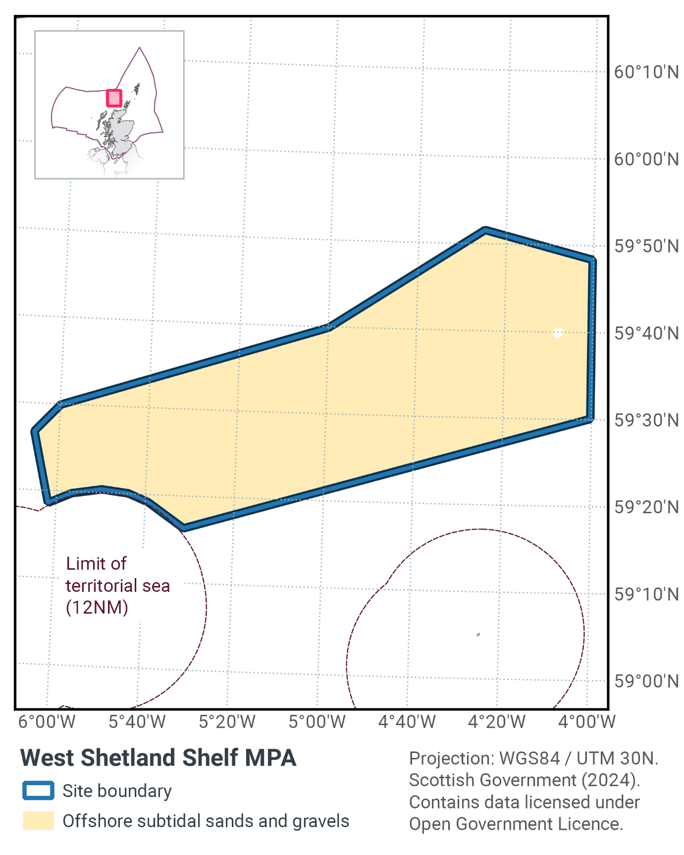
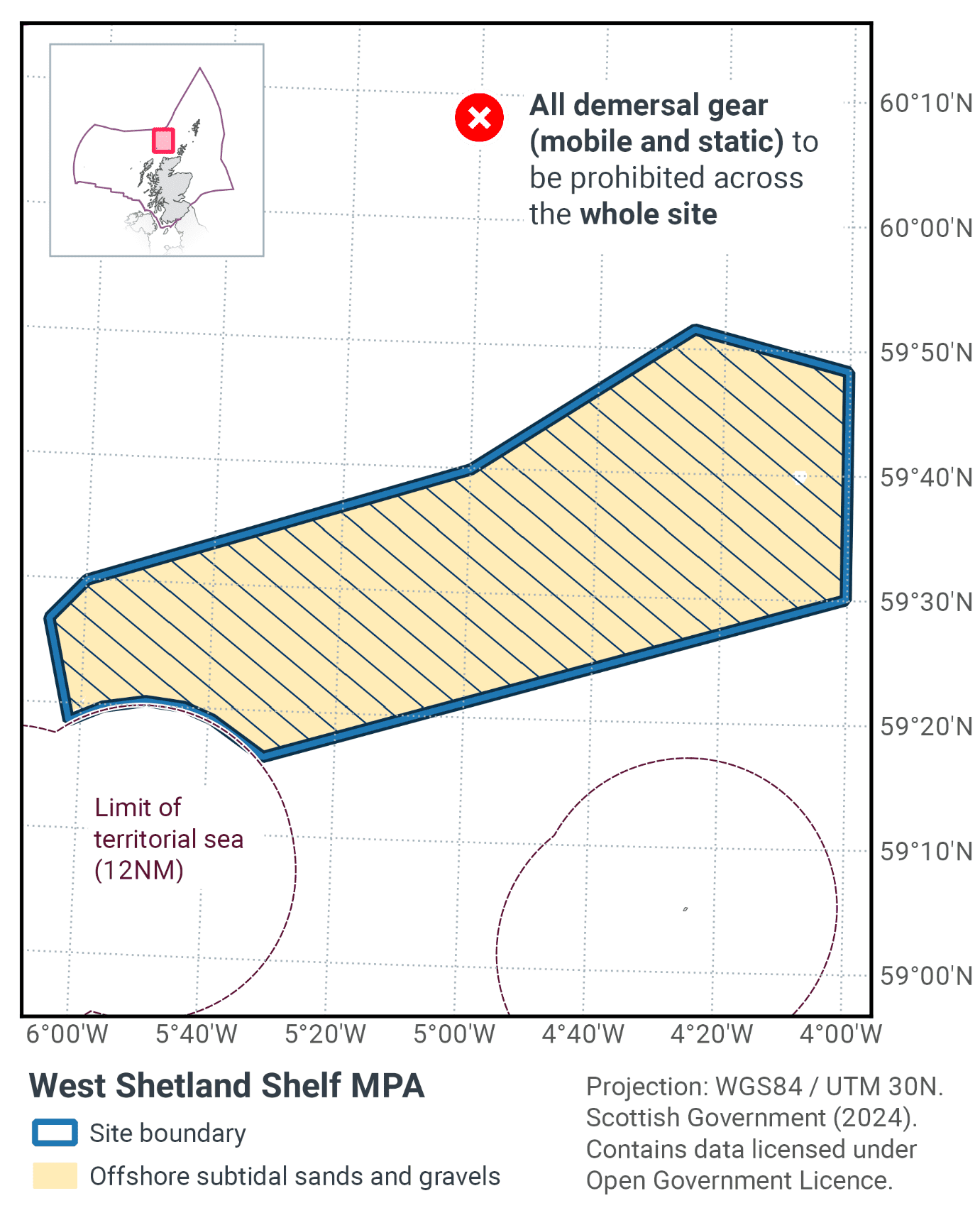
Lying to the north of Scotland, the West Shetland Shelf MPA provides an important example of the northern extent of sand and gravel habitats on the Scottish continental shelf. The MPA, shown in Figure 78, has an area of 4083 km2.
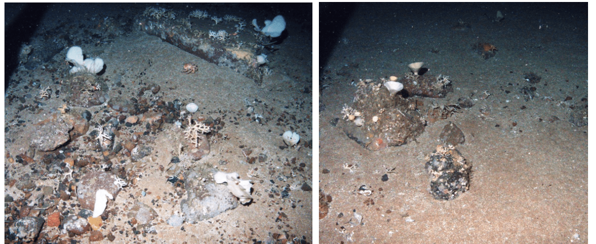
The different types of sand and gravel habitats support particularly rich diversity of wildlife. On the surface anemones, cup sponges (Axinella infundibuloformis) and several types of crustaceans including hermit crabs and squat lobster (Munida rugosa) can be found living between small rocks, whilst urchins and starfish (such as Porania pulvillus and Asterias rubens) are typical fauna living on the surface of the sandier sediments (Figure 79). Bryozoans and encrusting sponges are often found growing on the surface of cobbles and pebbles. Sea snails, bivalves such as scallops, keel worms and sand mason worms (Lanice conchilega) are adapted to living buried into the sand to avoid predators.
Further information can be found in the Site Information Centre.
28.2 Site Features
The West Shetland Shelf MPA is designated for the following protected features:
- Offshore subtidal sands and gravels.
The protected feature of the site is considered to be a priority in terms of marine conservation in Scotland’s seas and appropriate for a spatial management approach.
The MPA provides a coherent example of offshore subtidal sand and gravel habitats in OSPAR Regions II and III. It was chosen because at the time it overlapped with the fisheries restriction area (Regulation No 227/2013 of the European Parliament and of the Council), known locally as the windsock, which was managed for the recovery of cod stocks[4].
More information regarding the site selection process for the West Shetland Shelf MPA is available in the detailed assessment against the Scottish MPA Selection Guidelines document.
28.3 Site Boundary
The boundary was set in accordance with the boundary setting principles outlined in the MPA Selection Guidelines. It encompasses the distribution of a range of offshore subtidal sand and gravel habitats representative of OSPAR Regions II and III, indicated by the predictive seabed habitat modelling of the EUSeaMap Project and verified by Particle Size Analysis data from sediment samples, seabed photographic imagery and grab sample data from surveys.
28.4 Conservation objectives
JNCC’s view on the overall condition of the site’s qualifying feature is that it is in favourable condition and therefore needs to be maintained at favourable condition.
The Conservation Objective for the West Shetland Shelf Nature Conservation Marine Protected Area is that the protected feature (Offshore subtidal sands and gravels):
- so far as already in favourable condition, remain in such condition; and
- so far as not already in favourable condition, be brought into such condition, and remain in such condition.
The full conservation advice documents can be found on the JNCC website. This includes the formal conservation advice for the site, background information and the full conservation objectives.
28.5 Pressure from demersal mobile fishing gear
In general, the impact of demersal mobile gear on sand and gravel sediments is relatively well understood. In high energy locations (i.e. of wave and/or tide exposed) the associated fauna tend to be well adapted to disturbance and as a result are more tolerant of fishing-related disturbance (Dernie et al., 2003; Hiddink et al., 2006). In lower energy locations, such as muddy sands and sand in deep water, sediments tend to be more stable and their associated fauna less tolerant of disturbance (Hiddink et al., 2006; Kaiser et al., 2006). Stable gravels often support a ‘turf’ of fragile species which are easily damaged by trawling and recover slowly (Collie et al., 2005; Foden et al., 2010). Trawling and dredging tend to cause increased mortality of fragile and long-lived species and favour opportunistic, disturbance-tolerant species (Eleftheriou & Robertson, 1992; Bergman & van Santbrink, 2000). Some particularly sensitive species may disappear entirely (Bergman & van Santbrink, 2000).
As with demersal trawls and dredges, demersal seines may impact the structure and function of sedimentary habitats and the long-term survival of their associated species. There are currently no direct studies on the physical impacts of demersal seines. Modelling studies suggest that demersal seines have a large overall footprint (i.e. the surface area covered during one hour fishing) (Eigaard et al. 2016). Hiddink et al. (2017) suggest that depletion of biota is highly correlated with seabed penetration depth by trawls. Seines lack the heavy gear components (e.g. otter doors, trawl shoes) of other demersal mobile gears (Suuronen et al. 2012; Donaldson et al. 2010) and therefore, despite the relatively large footprint, impacts associated with penetration into the sediment are likely to be lower. Eigaard et al. (2016) modelled surface (<2cm) and subsurface (>2cm) impacts and found that demersal seines have some of the smallest proportions of subsurface impact.
28.6 Pressure from demersal static fishing gear
Although the individual impact of a single fishing operation may be slight, cumulative damage may be significant (Eno et al., 2001; Foden et al., 2010), however sensitivity to low intensity potting is considered low (Hall et al., 2008). Overall, the protected feature within the site is not considered to be sensitive to demersal static gear activity.
28.7 Levels of fisheries management considered
Table 52 provides a summary of the management advice set out against the various options that have been considered.
(Table 52) Summary of fisheries management advice for West Shetland Shelf MPA
Fisheries management options considered for demersal mobile gears
No additional management: There is a risk of not achieving the conservation objective for offshore subtidal sands and gravels.
Reduce / limit pressures: This level of management would reduce, but not entirely eliminate, the risk of not achieving the conservation objective for offshore subtidal sands and gravels. Appropriate management could include a zoned approach, where management measures would apply to all potentially impacting gears (not just trawls and seines) to protect a proportion of the feature representing the full diversity of the sand and gravel habitats. There may be a greater requirement for restrictions on gears that penetrate deeply into the sediment. Restrictions could be permanent in some cases or temporary/adaptive in others.
Remove / avoid pressures: This level of management would minimise the risk of not achieving the conservation objectives for offshore subtidal sands and gravels to the lowest possible levels. This is likely to include restrictions on gears that could impact the feature, such as otter trawling and scallop dredging.
Fisheries management options considered for demersal static gears
No additional management: It is unlikely that any additional management of creeling and potting activities will be required, as the risk of not achieving the conservation objective for offshore subtidal sands and gravels associated with these activities is minimal. However, if static gear fishing activities were to increase or monitoring showed evidence of detrimental effects, it may be necessary to apply limits in the future.
28.8 Other fisheries measures which apply to the site
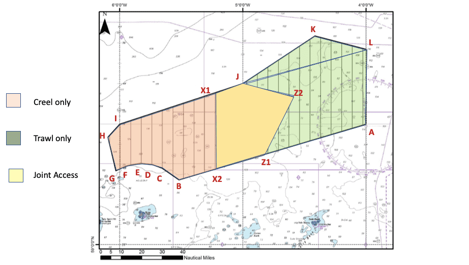
In 2019, existing management measures in place (the EU Cod Recovery Plan, commonly known as the Windsock[5]) which included the West Shetland Shelf MPA were withdrawn. While these management measures were not in place for the protection of the MPA protected features, they had the effect of partially benefitting the protected features. In 2020, the fishing industry agreed voluntary measures across the site which resulted in a split between static and mobile gears and a shared area (Figure 80) with the areas for each gear type being switched on a regular basis.
These voluntary measures are to continue until the implementation of the proposed fisheries measures above, at which point the rotation of access will then apply to the three zones open to mobile gear.
28.9 Proposed fisheries management and rationale
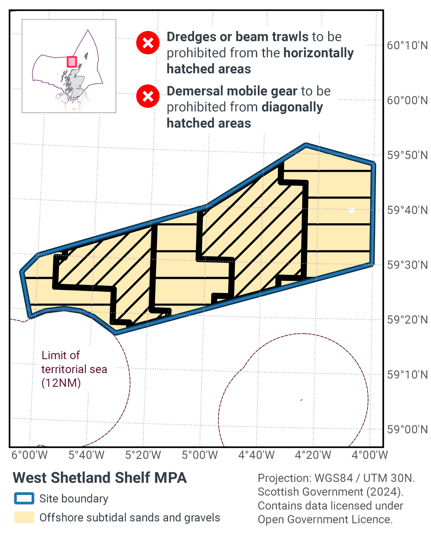
Table 53 and Figure 81 provide details of the proposed management approach and further explanation is provided below. Figure 82 shows the proposed fisheries management for full site prohibitions.
Protected feature |
Gear type |
Proposed management |
Measures |
|---|---|---|---|
Offshore subtidal sands and gravels |
Demersal mobile gear |
Reduce / limit pressures |
Prohibit use of dredges and beam trawls in the full extent of the MPA. Prohibit demersal trawl and seine in 50% of the MPA. |
Demersal static gear |
No additional management |
No demersal static gear measures applied |
In the assessment period there has been no use of dredges or beam trawls within the site. It is believed that it may have been tried once or twice a long time ago. There we have concluded that use of that gear type should be prohibited on a precautionary basis. This ensures that there will be no increase in pressure in the future.
Contact
Email: marine_biodiversity@gov.scot
There is a problem
Thanks for your feedback