Fisheries Management Measures within Scottish Offshore Marine Protected Areas (MPAs) - Site Proposal Document
This document describes the process, justification and evidence used to develop site specific management measures. It outlines key information for each site including their features, and risks of potential pressures.
29. Wyville-Thomson Ridge SAC
29.1 Description and background
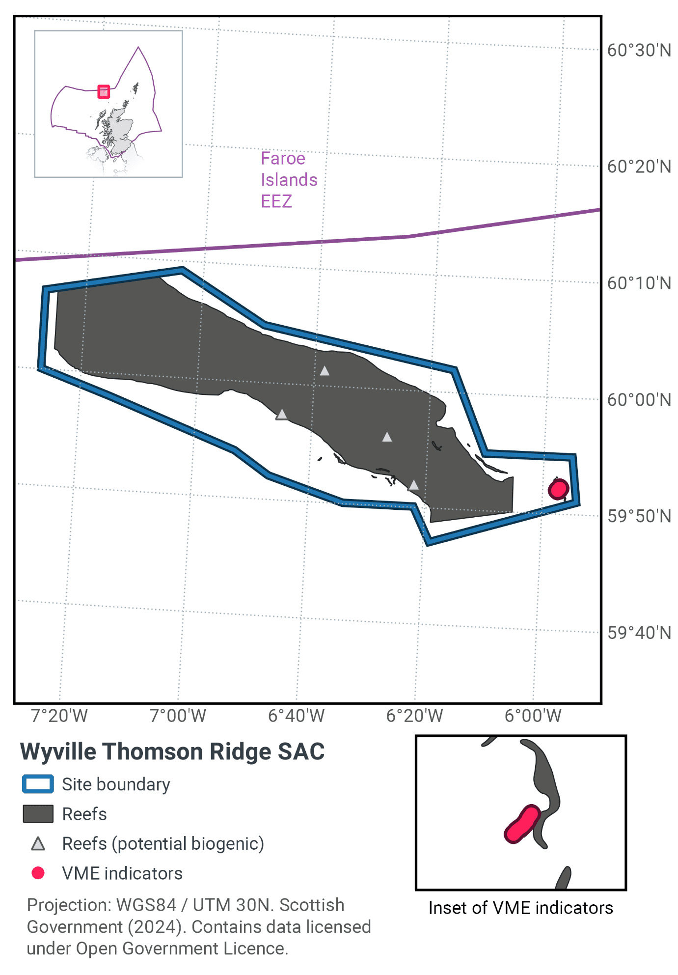
The Wyville-Thomson Ridge SAC is located approximately 150 km north west of Cape Wrath and extends in a north westerly direction towards the Faeroe Bank, as shown in Figure 83. The Ridge divides the warmer waters of the Rockall Trough from the cooler waters of the Faroe-Shetland Channel, and is a transitional area between the two water masses. The Wyville-Thomson Ridge is approximately 20 km wide and 70 km long and rises from over 1000 m depth to less than 400 m at the summit. The ridge is composed of extensive areas of stony reef interspersed with gravel areas and bedrock reef along its flanks.
The stony reef is thought to have been formed by the ploughing movement of icebergs through the seabed at the end of the last ice age. These iceberg ‘ploughmarks’ consist of ridges of boulders, cobbles and gravel where finer sediments have been winnowed away by high energy currents at the site, interspersed with finer sediment troughs up to 10 m deep (Masson et al., 2000).
The bedrock and stony reef areas in the site support diverse biological communities representative of hard substrate in deep water, including a range of sponges; stylasterid, cup and soft corals; brachiopods; bryozoans; dense beds of feather stars and brittle stars; sea urchins, sea cucumbers and sea spiders (Masson et al., 2000; Brian Bett, pers comm., 2004; Henry & Roberts, 2004; Howell et al., 2007; Morris et al., 2014) (Figure 84). Communities on the bedrock reef vary in species composition between the two sides of the site due to the influences of different water masses on either side of the ridge (Howell et al., 2007).
Further information can be found in the Site Information Centre.
29.2 Site Features
The Wyville Thompson Ridge SAC is designated for the following protected features:
- Stony and bedrock reef (Annex I Reefs).
This site represents full salinity stony and bedrock reef, subject to moderate/high energy levels and minimal coastal influence. The ridge is periodically exposed to hydrodynamic conditions associated with the Faroe-Shetland Channel (Borenäs et al., 2001) and this has led to the development of a unique reef habitat, with species composition varying either side of the ridge (Howell et al., 2007). The site therefore makes a contribution to the UK Network for Annex I reef (H1170).
The SAC is approximately 1,740 km2 and it should be noted that iceberg ploughmarks are a mosaic habitat consisting of boulders and cobbles in the ploughmark ridges with finer sand in the troughs.
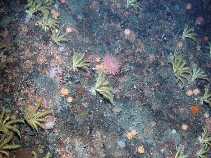
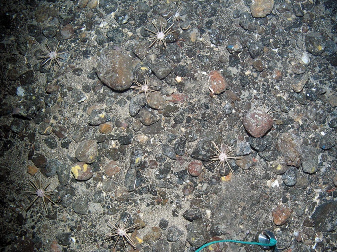
Figure 84. Feature images from Wyville Thomson Ridge (© JNCC, 2012) a) Annex I reef dominated by the northern feather star (Heliometra glacialis), anthozoans including the sea anemone Actinostola callosa plus a soft coral (Nephtheidae) and small brittle stars (Ophiuroidea indet.); and b) pencil sea urchins (Cidaris cidaris) on Annex I stony reef with encrusting sponges
Feature |
Area of habitat (km2)[6] |
|---|---|
Area interpreted as iceberg ploughmarks |
1,020 |
Predicted stony reef[7] |
1,398 |
29.3 Site Boundary
The boundary for the Wyville-Thomson Ridge SAC was defined using the JNCC SAC boundary definition guidelines (JNCC, 2012a). The proposed boundary is a simple polygon which includes a buffer of 1,700 m around the reef habitat. This is two times the maximum water depth of 850 m.
29.4 Conservation objectives
JNCC’s view on the overall condition of the site’s qualifying feature is that it is in unfavourable condition and therefore needs to be restored to favourable condition.
The Conservation Objectives for the Wyville-Thomson Ridge SAC are for the feature to be in favourable condition thus ensuring site integrity in the long term and contribution to Favourable Conservation Status of Annex I Reefs.
This contribution would be achieved by maintaining or restoring, subject to natural change: • The extent and distribution of the qualifying habitat in the site;
- The structure and function of the qualifying habitat in the site; and
- The supporting processes on which the qualifying habitat relies.
The full conservation advice documents can be found on the JNCC website. This includes the formal conservation advice for the site, background information and the full conservation objectives.
29.5 Pressure from demersal mobile fishing gear
Whilst it is unlikely that demersal mobile gears can affect the long-term natural distribution of bedrock and stony reef features, there is evidence to indicate that their use can impact the structure and function of the habitat and the long term survival of its associated species.
The use of demersal mobile fishing gears is likely to cause damage or death of fragile, erect species, such as sponges and corals (Freese et al., 1999; Løkkeborg, 2005). Other species such as hydroids, anemones, bryozoans, tunicates and echinoderms may also be vulnerable (McConnaughey et al., 2000; Sewell & Hiscock, 2005). Where fragile, slow growing species occur, even low levels of fishing have the potential to change the structure and function of the habitats and may result in the loss of some characteristic species.
29.6 Pressure from demersal static fishing gear
Mechanical impacts of demersal static gear (e.g. weights and anchors hitting the seabed, hauling gear over seabed, rubbing/entangling effects of ropes) can damage some species (Eno et al., 1996). Other species appear to be resilient to individual fishing operations but the effects of high fishing intensity are unknown (Eno et al., 2001). Recovery will be slow (Foden et al., 2010) resulting in significant reduction or even loss of characteristic species. The individual impact of a single fishing operation may be slight but cumulative damage may be significant (Eno et al., 2001; Foden et al., 2010).
29.7 Levels of fisheries management considered
Table 55 provides a summary of the management advice set out against the various options that have been considered.
(Table 55) Summary of fisheries management advice for Wyville-Thomson Ridge SAC
Fisheries management options considered for demersal mobile gear
No additional management: There is a significant risk of not achieving the conservation objectives for the reef feature.
Reduce / limit pressures: This level of management would reduce the risk of not achieving the conservation objectives for the reef feature. Appropriate management could include the exclusion of demersal mobile gears over the main areas of bedrock and stony reef, allowing fishing to continue in fishable areas around the features. It is possible that these areas may include some areas where the distribution of reef is unknown or uncertain as well as small areas of known Annex I reef. As such, there would be a risk of localised impact to the structure and function of reef communities in these areas. The location of areas to be covered by management restrictions could include a buffer zone to reduce any risk of accidental contact with the feature.
Remove / avoid pressures: This level of management would reduce the risk of degradation to any reef feature within the site boundary to the lowest possible levels. Restrictions would be required for all demersal mobile gears within the full extent of the site boundary.
Fisheries management options considered for demersal static gear
No additional management: This level of management is considered to be sufficient for demersal static gear to achieve the conservation objectives for the reef feature, unless associated VMEs are present. If monitoring showed evidence of detrimental effects as a result of static gear activity in the future, additional management may be required..
Reduce / limit pressures: This level of management would further reduce the risk not achieving the conservation objectives for the reef feature, in particular if any VMEs are present. If fishing activity were to rise to levels at which damage was occurring, appropriate management could include partial closure of the feature and/or limits on the amount of gear that can be deployed.
29.8 Other fisheries measures which apply to the site
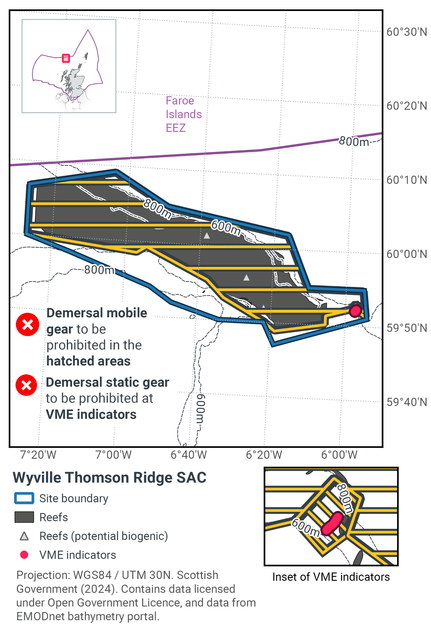
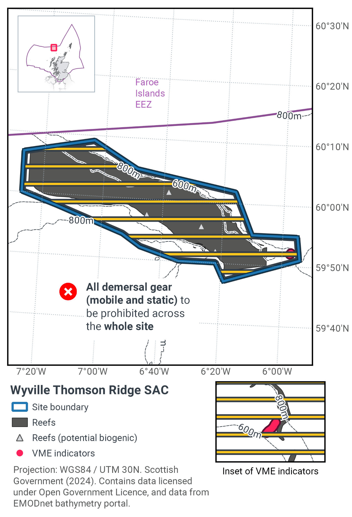
Part of this proposal is to prohibit trawling in waters greater than 800 m depth, this measure is also enforced in the new EU-wide Deep Sea Fisheries Regulation ((EU) 2016/2336). This came into force in January 2017 and was transposed into UK legislation via The Common Fisheries Policy and Aquaculture (Amendment etc.) (EU Exit) Statutory Instrument (S.I.) 2019 No. 753.
29.9 Proposed fisheries management and rationale
Figure 85 shows proposed management measures with proposals detailed in Table 56 with further explanation. Figure 86 shows the proposed fisheries management for full site prohibitions.
Protected feature |
Gear type |
Proposed management |
Measures |
|---|---|---|---|
Stony and bedrock reef |
Demersal mobile gear |
Reduce / limit pressure |
Prohibit all demersal mobile gear fisheries from a proportion of the site, including the area interpreted as iceberg ploughmarks |
Demersal static gear |
Reduce / limit pressure |
Prohibit activity where VME indicator species have been found in association with the protected reef in the SAC |
The management proposal is to prohibit demersal mobile gears from a proportion of the SAC to protect Annex I reef, including areas where the extent of predicted reef layer overlaps with areas interpreted as iceberg ploughmarks. Proportions are shown in Table 57.
Iceberg ploughmarks are relict features that occur along the UK continental shelf edge off northern and western Scotland and provide patchy areas of hard substratum on the seabed in areas otherwise dominated by soft sediments. Iceberg plough-marks give rise to raised areas of cobbles and small boulders either side of a central furrow.
Additional measures for demersal static gear are proposed for an area where VME indicator species have been identified in association with the protected feature. VMEs are particularly sensitive to demersal static gears (in addition to demersal mobile gears) and these records provide evidence of the existence or potential for VME habitats.
Feature |
Area of habitat (km2) |
Area of habitat covered by management measures (km2) |
% of habitat covered by management measures |
|---|---|---|---|
Predicted stony reef |
1023 |
1022 |
99.9 |
Contact
Email: marine_biodiversity@gov.scot
There is a problem
Thanks for your feedback