Fisheries Management Measures within Scottish Offshore Marine Protected Areas (MPAs) - Site Proposal Document
This document describes the process, justification and evidence used to develop site specific management measures. It outlines key information for each site including their features, and risks of potential pressures.
6. Braemar Pockmarks SAC
6.1 Description and background
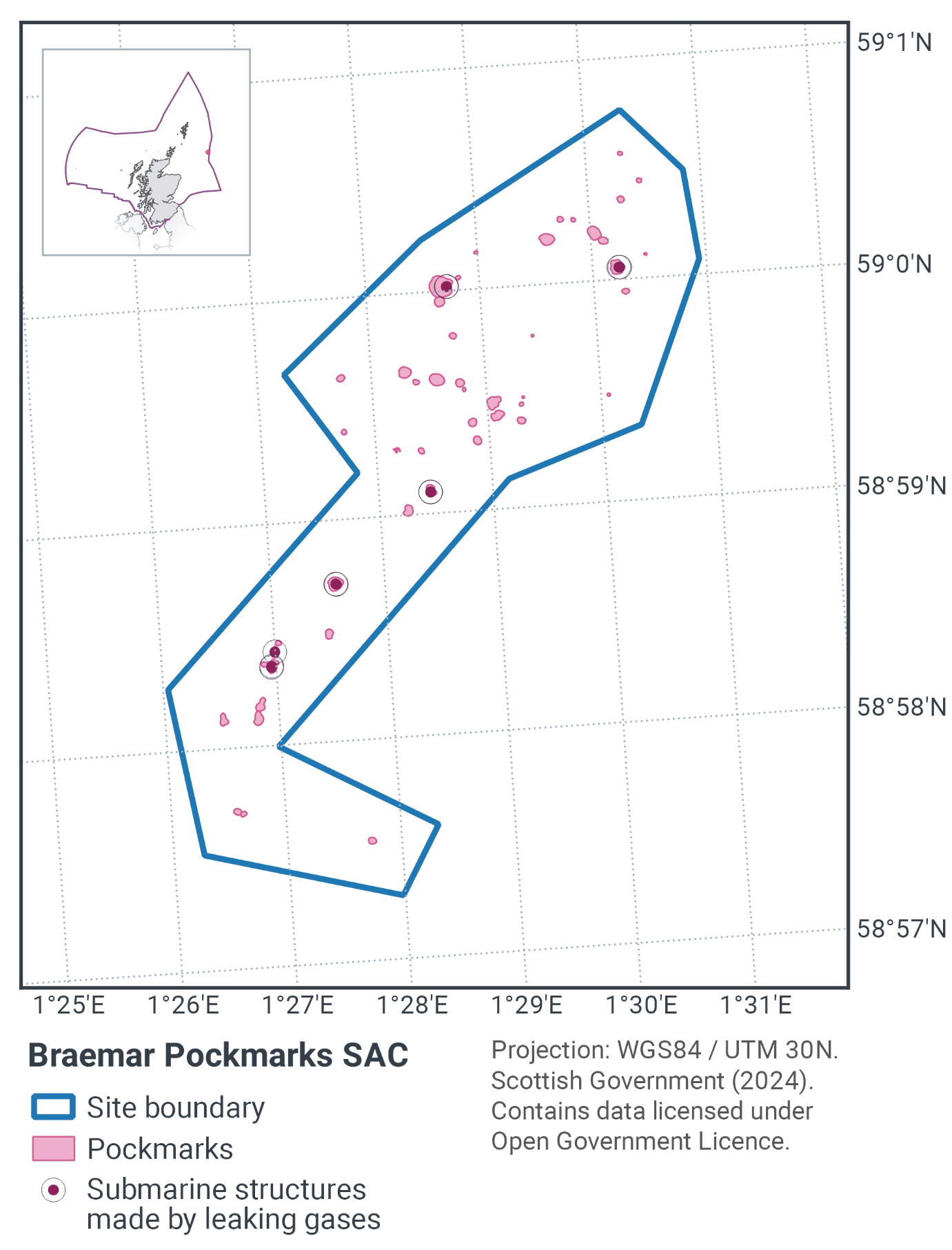
Braemar Pockmarks SAC, as shown in Figure 3 and Figure 5, is located approximately 240 km east of the Orkney Islands. There are 48 pockmark depressions within the site ranging in size from 40 cm deep with an area of 330 m² to 4 m deep and 10,000 m² in area. The Braemar pockmarks were discovered initially during rig site surveys as part of the Braemar oil field development. Further industry-led surveys in 2001 and 2003 confirmed the presence of Annex I habitat submarine structures made by leaking gases (code 1180).
The pockmarks at the site are shallow, ovoid seabed depressions which were probably formed by the venting of biogenic/petrogenic fluids or gases into the water column (Hovland & Judd, 2009). Large blocks, pavement slabs and smaller fragments of methane derived authigenic carbonate (MDAC) have been deposited through a process of precipitation during the oxidation of methane gas.
Survey data from 2012 suggested strong evidence of active gas seepage including presence of MDAC and gas bubbles in the water column (Rance et al., 2013).
Exposed carbonate structures provide a habitat for marine fauna usually associated with rocky reef, as well as highly specific chemosynthetic organisms which feed off both methane (seeping from beneath the seafloor) and its by-product, hydrogen sulphide (Judd, 2001). Larger blocks of exposed carbonate may also provide shelter for mobile demersal species (Figure 4).
Further information can be found in the Site Information Centre.
6.2 Site Features
The Braemar Pockmarks SAC is designated for the following protected feature:
- Submarine structures made by leaking gases.
The Braemar Pockmarks site is located in the Northern North Sea and represents a range of different sizes and forms of Annex I submarine structures made by leaking gases” (H1180). It therefore makes a contribution to the UK Network for this habitat. The faunal communities are representative of those present on submarine structures made by leaking gases, consisting of organisms dependent on chemosynthesis as well as anemones and hydroids (Hartley, 2005).
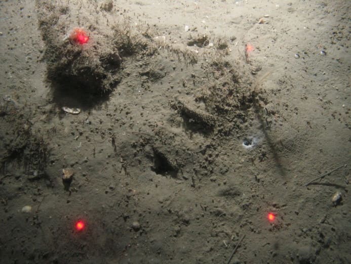
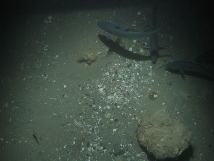
Figure 4. Feature images from Braemar Pockmarks SAC, showing a) methane derived authigenic carbonate (MDAC) partially covered by sediment, and b) a block of MDAC with shell hash on mud sediment with hunting Saithe (Pollacius virens) © JNCC/Cefas
6.3 Site Boundary
The site was defined using the JNCC marine SAC boundary definition guidelines (JNCC, 2012a). The boundary was drawn as a simple polygon around the known extent of the pockmarks at the time of designation. This included a buffer of 375 m from the edge of the pockmark depression which equates to three times the maximum water depth of 125 m. The site area was 5.18 km2 when designated and comprised a simple polygon to encompass known records of submarine structures made by leaking gases in the vicinity.
A survey of the site, conducted in 2012 and commissioned by JNCC, discovered a further 21 pockmarks outside the original site boundary. An amendment to the site boundary for Braemar Pockmarks SAC to encompass these features was consulted on in 2017 and approved and submitted to the European Commission in September 2018.
6.4 Conservation objectives
JNCC’s view on the overall condition of the site’s qualifying feature is that it is in unfavourable condition, noting it is not considered feasible to restore some of the feature’s attributes using management intervention.
The conservation objectives for the Braemar Pockmarks SAC are for the feature to be in favourable condition thus ensuring site integrity in the long term and contribution to Favourable Conservation Status of Annex I Submarine structures made by leaking gases.
The full conservation advice documents can be found on the JNCC website. This includes the formal conservation advice for the site, background information and the full conservation objectives.
6.5 Pressure from demersal mobile fishing gear
Direct evidence of impacts of demersal mobile gears to submarine structures made by leaking gasses is limited. However, the biological communities that develop on exposed structures typically include many of the same species that can be found on subtidal rocky habitats in similar environmental conditions, and it is likely that the effects of fishing will be similar.
The use of demersal mobile fishing gears is likely to cause damage or death of fragile, erect species, such as sponges and corals (Freese et al., 1999; Løkkeborg, 2005). Other species such as hydroids, anemones, bryozoans, tunicates and echinoderms are vulnerable to mobile fishing gear (McConnaughey et al., 2000; Sewell & Hiscock, 2005). Recovery is likely to be slow (Foden et al., 2010). Where fragile, slow growing species occur, even low levels of fishing have the potential to change the structure and function of the habitats and may result in the loss of some characteristic species.
6.6 Pressure from demersal static fishing gear
There is no direct evidence from which to determine impacts of static gears on submarine structures made by leaking gases. However, the biological communities that develop on exposed structures typically include many of the same species that can be found on subtidal rocky habitats in similar environmental conditions, and it is likely that the effects of fishing will be similar.
Mechanical impacts of static gear (e.g. weights and anchors hitting the seabed, hauling gear over seabed, rubbing/entangling effect of ropes) can damage some species (Eno et al., 1996). Other species appear to be resilient to individual fishing operations, but the effects of high fishing intensity are unknown (Eno et al., 2001). Recovery may be slow, resulting in significant reduction or even loss of characteristic species (Foden et al., 2010). The individual impact of a single fishing operation may be slight but cumulative damage may be significant (Eno et al., 2001; Foden et al., 2010).
6.7 Levels of fisheries management considered
Table 6 provides a summary of the fisheries management advice set out against the various management levels that have been considered.
(Table 6) Summary of fisheries management advice for Braemar Pockmarks
Fisheries management levels considered for demersal mobile gears
No additional management: There is a significant risk of not achieving the conservation objectives for the submarine structures made by leaking gases.
Reduce / limit pressures:
This level would reduce, but not entirely eliminate, the risk of degradation to the submarine structures made by leaking gases feature as a result of direct impact from fishing activities. Appropriate management could include closure of the known extent of the feature within the site. However, a risk of impact with patches of feature not identified during survey would remain. Recent survey evidence suggests that patches of feature extend across the site beyond those listed in the original submission thus the risk of damage to the feature from fishing activity within the site is high. Although the risk of damage to the feature is likely to be highest for heavy gear components, restrictions may be appropriate for all demersal mobile gears to minimise the risk of fragmentation of exposed feature. Areas to be covered by management restrictions would include a buffer zone around the known features equal to three times the water depth to reduce any risk of accidental contact with the feature.
Remove / avoid pressures: This level would reduce the risk of degradation to any submarine structures made by leaking gases feature within the site boundary to the lowest possible levels. Restrictions would be required for all demersal mobile gears within the full extent of the site boundary. The boundary already includes a buffer zone around the known features equal to three times the water depth to reduce any risk of accidental contact with the feature.
Fisheries management level considered for demersal static gears
No additional management: The risk of deterioration of the submarine structures made by leaking gases from set netting is considered minimal. This level of management is considered appropriate for all demersal static gears. However, if static gear fishing were to increase and monitoring showed evidence of detrimental effects, it may be necessary to apply restrictions in the future.
6.8 Proposed fisheries management and rationale
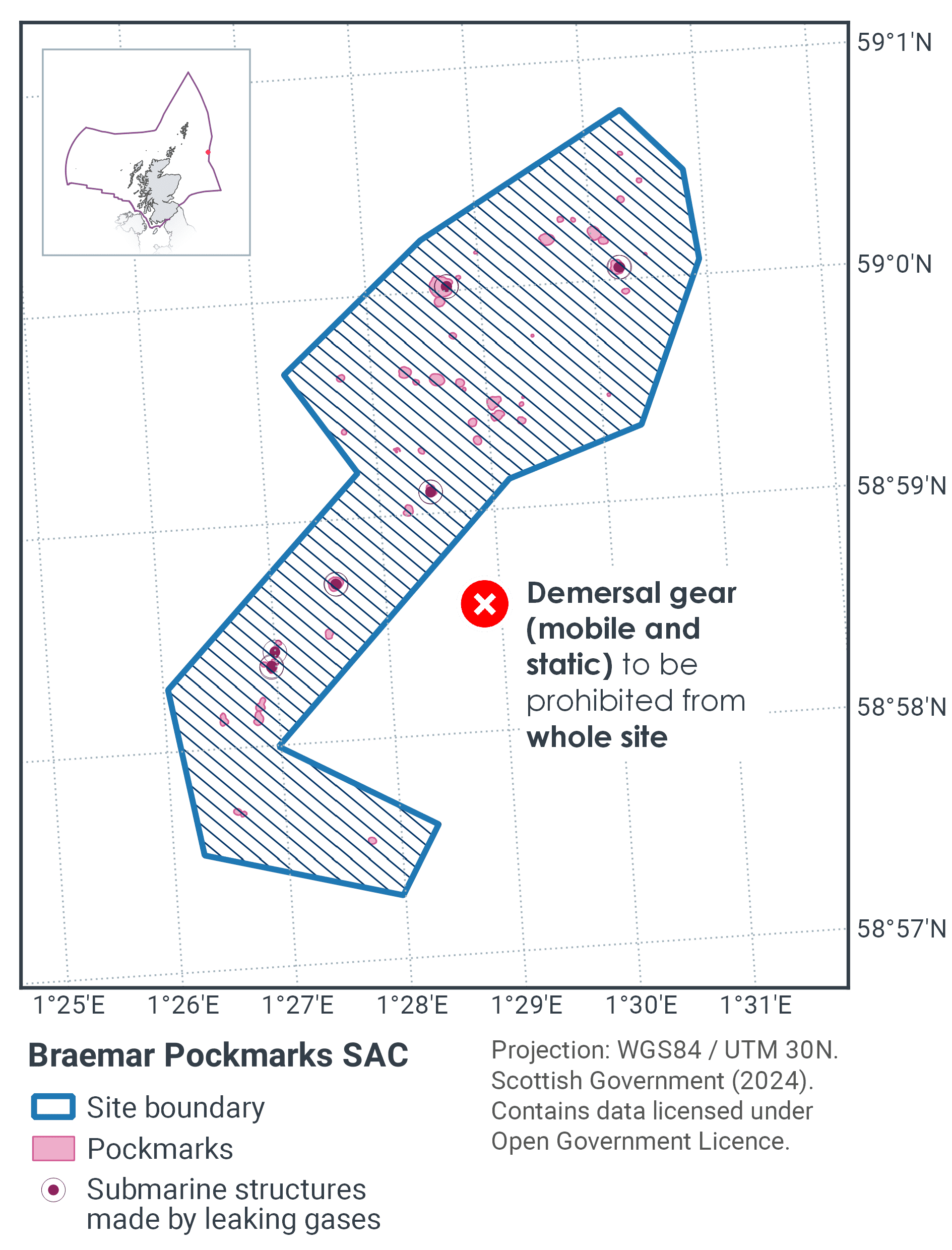
Table 7 and Figure 5 provides details of the proposed fisheries management approach with further explanation provided below.
Protected feature |
Gear type |
Proposed management |
Measures |
|---|---|---|---|
Submarine structures made by leaking gases |
Demersal mobile |
Remove / avoid pressures |
Prohibit all demersal mobile fisheries from the SAC |
Demersal static |
Remove / avoid pressures |
Prohibit all demersal static fisheries from the SAC |
The submarine structures are in effect irreplaceable. If the carbonate substrate was damaged or removed from the site, then recovery would be virtually impossible. Therefore, the risk of fishing impact has to be reduced to the lowest possible level.
Management measures are proposed for demersal mobile gears to remove the risk to achieving the conservation objective posed by these gears. In addition, while the risk to achieving the conservation objective posed by demersal static gears is considered minimal, the scale of this site means that control and enforcement of fishing activity within the SAC would be very difficult. Therefore, the practical approach is to prohibit all demersal mobile and demersal static gears across the whole SAC; thereby limiting this site to single management proposal.
The measures should also help to improve the status of the seapens and burrowing megafauna Threatened and/or Declining habitat in OSPAR region II through its incidental protection as these are found in the immediate area surrounding the submarine structures (JNCC, 2018). They should also further progress towards Good Environmental Status in the Greater North Sea, particularly in relation to Descriptors 1 (biological diversity) and 6 (sea-floor integrity).
Contact
Email: marine_biodiversity@gov.scot
There is a problem
Thanks for your feedback