Fisheries Management Measures within Scottish Offshore Marine Protected Areas (MPAs) - Site Proposal Document
This document describes the process, justification and evidence used to develop site specific management measures. It outlines key information for each site including their features, and risks of potential pressures.
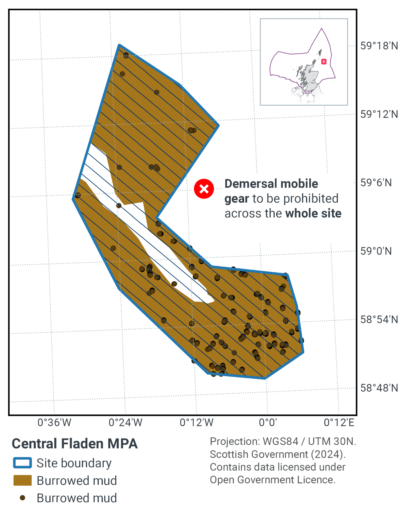
7. Central Fladen MPA
7.1 Description and background
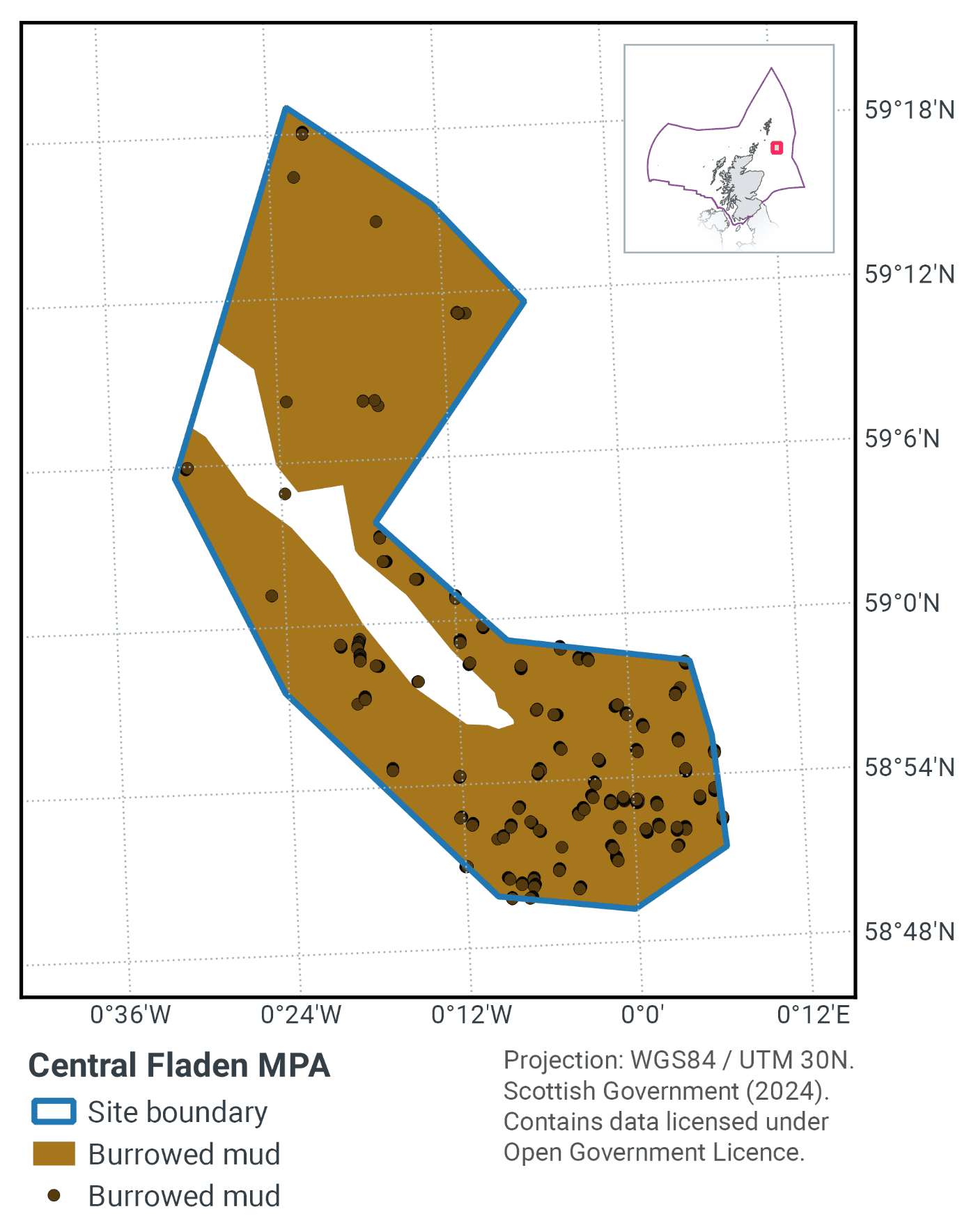
The Central Fladen MPA, as shown in Figure 6 and Figure 7, lies within the Fladen Grounds, which is a large area of mud located in the northern North Sea. The MPA covers an area of 925 km². The mud habitat within the site is characterised by sea pens, and the burrows made by crustaceans such as the mud shrimp Callianassa subterranea and the Norway lobster Nephrops norvegicus. The burrowing activity of megafauna creates a complex habitat, providing deep oxygen penetration.
The MPA includes the seapens and burrowing megafauna biotope and records of the tall seapen (Funiculina quadrangularis). Pictures of these are shown in Figure 7. These equate to the OSPAR habitat seapens and burrowing megafauna which is considered to be Threatened and/or Declining in OSPAR regions II and III.
The MPA ranges in depth from 100 m to 280 m in the ‘Fladen Deeps’ sub-glacial tunnel valley that runs through the MPA.
Further information can be found in the Site Information Centre.
7.2 Site Features
The Central Fladen MPA is designated for the following protected feature:
- Burrowed mud.
The MPA makes a contribution to the OSPAR network for the seapens and burrowing megafauna Threatened and/or Declining habitat in OSPAR region II. The site also includes records of the tall seapen (Funiculina quadrangularis) which is rarely found in the northern North Sea. The site also includes an important geodiversity feature, the ‘Fladen Deeps’ sub-glacial tunnel valley.
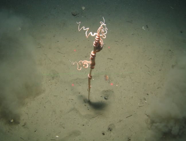
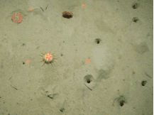
Figure 7. Feature images from Central Fladen MPA (© Cefas and JNCC, 2013) a) Tall seapen (Funiculina quadrangularis) and brittlestar on burrowed mud, b) seapen, sea urchin and burrows.
7.3 Site Boundary
The boundary of the Central Fladen MPA has been set in accordance with the boundary setting principles outlined in the MPA Selection Guidelines.
The boundary was drawn to include survey records of the seapens and burrowing megafauna habitat, mostly including areas where the distribution of the seapen species meet or exceed the average density of seapens from across the wider Fladen Grounds (Greathead et al., 2011). The southern part of the MPA boundary includes one of the few areas where tall seapen have been recorded in Scottish offshore waters; the boundary tracks the predicted distribution of the typical habitat type for this species (muddy sand) (Ager & Wilding, 2009).
The site boundary was also drawn to encapsulate a sub-glacial tunnel-valley geodiversity feature. This is scientifically important as it holds potentially valuable evidence about past changes in the extent and geometry of the last British-Irish Ice Sheet (Brooks et al., 2013).
Confidence in the presence and extent of the protected features has been set out in the Data Confidence Assessment.
7.4 Conservation objectives
JNCC’s view on the overall condition of the site’s qualifying feature ‘Burrowed mud’ is that it is in unfavourable condition and therefore needs to be restored to favourable condition.
JNCC’s view on the overall condition of the site’s qualifying feature ‘Sub-glacial tunnel valley’ is that it is in favourable condition and therefore needs to be maintained.
The Conservation Objectives for North West Rockall Bank are that the protected features:
- so far as already in favourable condition, remain in such condition; and
- so far as not already in favourable condition, be brought into such condition, and remain in such condition
The full conservation advice documents can be found on the JNCC website. This includes the formal conservation advice for the site, background information and the full conservation objectives.
7.5 Pressure from demersal mobile fishing gear
Studies have shown that areas of burrowed mud subject to mobile fishing activity support a modified biological community with lower diversity, reduction or loss of long-lived filter-feeding species and increased abundance of opportunistic scavengers (Tuck et al., 1998; Ball et al., 2000). This effect was greatest in the more heavily fished offshore areas suggesting that impact is related to the intensity of fishing (Ball et al., 2000).
Furthermore, modelling studies suggest that the greatest impact is produced by the first pass of a trawl (Hiddink et al., 2006). The distribution of the seapen Funiculina quadrangularis in Scottish waters may have been reduced as a result of Nephrops norvegicus trawling (Hughes, 1998). Nephrops norvegicus may be an important component of the benthic community so fisheries that greatly alter its abundance or size composition may have a negative impact.
7.6 Pressure from demersal static fishing gear
None of the protected features within the site are considered sensitive to static gear activity. Studies on the impacts of pots on seapens have shown limited adverse effect on seapens from a single fishing operation (Eno et al., 1996; Eno et al., 2001; Kinnear et al., 1996). However, the extent of damage and the impacts of repeated exposure to these types of fishing gear at high levels of fishing activity are less well understood (Eno et al., 2001; Adey, 2007).
If fishing activity is low, direct impact on habitat is likely to be minimal and seabed structure is likely to be maintained in a slightly modified state (Adey, 2007). Nephrops norvegicus may be an important component of the benthic community so fisheries that greatly alter its abundance or size composition may be seen to have a negative impact.
7.7 Levels of fisheries management considered
Table 8 provides a summary of the fisheries management advice set out against the various levels of management that have been considered.
(Table 8) Summary of fisheries management advice for Central Fladen MPA
Fisheries management levels considered for demersal mobile gear
No additional management: There is a significant risk of not achieving the conservation objective for the burrowed mud feature.
Reduce / limit pressures: This level of management would reduce, but not entirely eliminate, the risk of not achieving the conservation objective for the burrowed mud feature. Appropriate management for burrowed mud could include closure of a proportion of the site to damaging gears. Restrictions could be permanent in some cases or temporary/adaptive in others. Restrictions may be proposed for the more sensitive areas such as those supporting the tall sea pen component, and a reduction of effort may also be required to minimise the risk of not achieving the conservation objective for the remaining burrowed mud feature.
Remove / avoid pressures: This level of management would reduce the risk of not achieving the conservation objective for burrowed mud to the lowest possible level.
Fisheries management levels considered for demersal static gear
No additional management: This level of management is considered to be sufficient for demersal static gear to achieve the conservation objectives for burrowed mud. However, if static gear fishing activities were to increase or monitoring showed evidence of detrimental effects, it may be necessary to apply limits in the future.
7.8 Other fisheries measures which apply to the site
The UK National North Sea Cod Avoidance Plan designates ‘Long Holes’ as a seasonal closure within the Central Fladen MPA. This constitutes a Real Time Closure between 1st January and 31st March within the MPA.
7.9 Proposed fisheries management and rationale
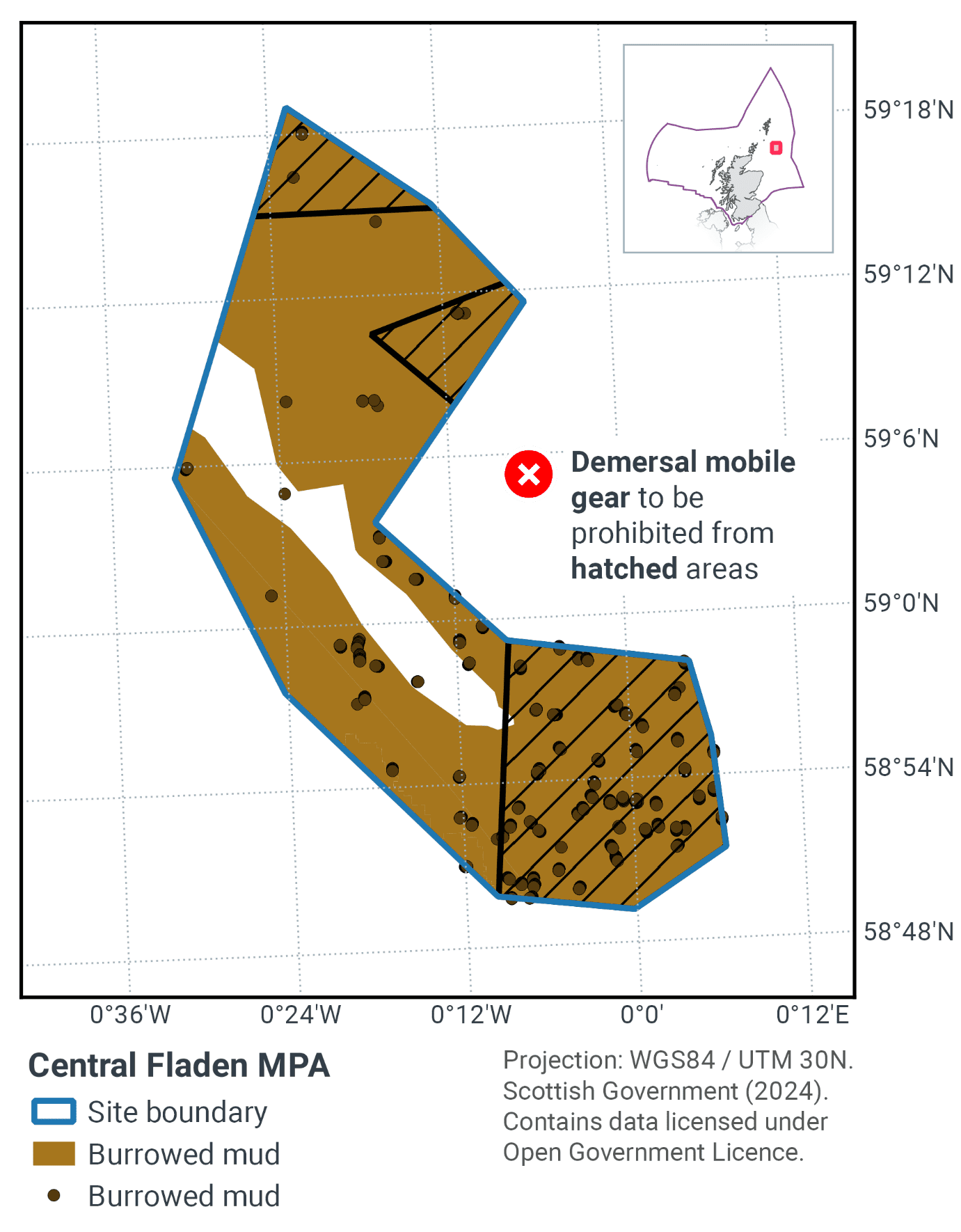
Table 9 and Figure 8 provides details of the proposed fisheries management approach and further explanation is provided below. Figure 9 shows the proposed fisheries management for full site prohibitions.
Protected feature |
Gear type |
Proposed management |
Measures |
|---|---|---|---|
Burrowed mud |
Demersal mobile gear |
Reduce/limit pressure |
Zonal exclusion of demersal mobile gears from three parts of the site |
Demersal static gear |
No additional management |
No demersal static gear measures applied |
The management proposal ensures that a proportion of the burrowed mud habitat is protected to further the conservation objectives. The part of the MPA where known records of Funiculina quadrangularis are found is fully protected from demersal mobile gears.
The measures should enable further colonisation of seapen Funiculina quadrangularis within the MPA, and/or other seapens. This should help improve the status of the seapens and burrowing megafauna Threatened and/or Declining habitat in OSPAR region II. They should also further progress towards Good Environmental Status in the Greater North Sea, particularly in relation to Descriptors 1 (biological diversity) and 6 (seafloor integrity).
Contact
Email: marine_biodiversity@gov.scot
There is a problem
Thanks for your feedback