Fisheries Management Measures within Scottish Offshore Marine Protected Areas (MPAs) - Site Proposal Document
This document describes the process, justification and evidence used to develop site specific management measures. It outlines key information for each site including their features, and risks of potential pressures.
9. Faroe-Shetland Sponge Belt MPA
9.1 Description and background
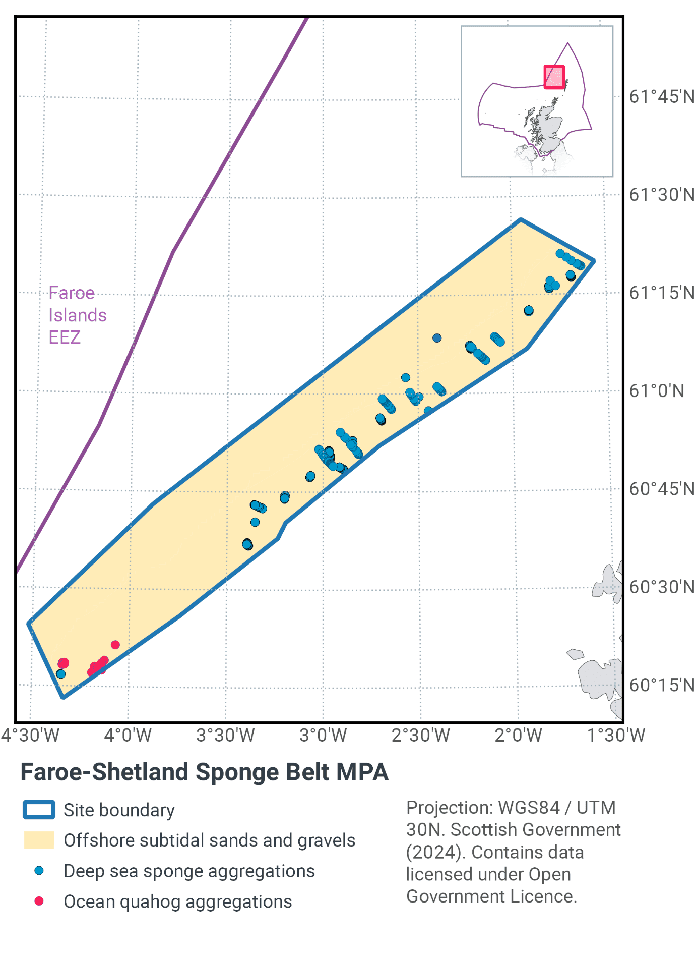
The Faroe-Shetland Sponge Belt MPA lies to the west of the Shetland Islands as shown in Figure 14 and Figure 16. The site is located in the Faroe-Shetland Channel, a large rift basin that separates the Scottish and Faroese continental shelves. The MPA ranges in depth from 400 m – 800 m.
Five different water masses which have different temperatures and densities meet in the Faroe-Shetland Channel. This creates intermediate water masses in the water column which interact with the sloping sides of the channel to produce an area of mixing between 350 and 650 m depth (Sherwin, 1991). Peak benthic diversity and abundance in the MPA occurs within the same depth range (Bett, 2000; Bett, 2001; Narayanaswamy et al., 2005; Narayanaswamy et al., 2010).
The higher current speeds created by these water masses, along with cobbles and boulders associated with iceberg plough marks, generate ideal conditions for the settlement of sponges (Bett, 2001; Axelsson, 2003). Deep-sea sponge aggregations (Figure 15 a-b) have been recorded in the channel between 400 and 600 m depth (Howell et al., 2007; Henry & Roberts, 2014; Morris et al., 2014). The type of deep-sea sponge aggregation which occurs within the Faroe-Shetland Sponge Belt MPA is boreal ‘ostur’ (Howell et al., 2007; Henry & Roberts, 2014). Boreal ‘ostur’ sponge aggregations typically have a high abundance of species of giant sponge (Demospongia).
There are two distinct offshore subtidal sands and gravels communities (Figure 15 c-d) within the site; one is found between 300 and 600 m, which are characterised by a greater proportion of cobbles and boulders; and a second deeper than 600 m, which are characterised by finer sands and muddy sands. The two communities are dominated by contrasting families of polychaete worm (Bett, 2012). The sedimentary habitats in the MPA also support ocean quahog (Arctica islandica).
Further information can be found in the Site Information Centre.
9.2 Site Features
The Faroe Shetland Sponge Belt MPA is designated for the following protected features:
- Ocean quahog aggregations
- Deep-sea sponge aggregations
- Offshore subtidal sands and gravels
- Continental slope
- Geodiversity interests – continental slope channels, iceberg ploughmark fields, prograding wedges, slide deposits, sand wave fields and sediment wave fields.
The MPA makes a contribution to the OSPAR network for protection of ocean quahog (an OSPAR Threatened and/or Declining species) in OSPAR region II at the northern extent of its range. It also represents Atlantic and Arctic influenced slope offshore subtidal sands and gravel habitats.
The offshore sand and gravels occur over the entire MPA area of 5,278 km2. The deep-sea sponge aggregation habitat occurs between the 400 m and 600 m contours. Large areas of sediment suitable for ocean quahog colonisation exist within the MPA although the exact extent and distribution of ocean quahog aggregations is uncertain.
Deep-sea sponges are also listed as an OSPAR Threatened and/or Declining species and are also considered to be a VME. The records of deep-sea sponge aggregations in the MPA conform to the boreal ‘ostur’ variation of the habitat and have high biological diversity (Howell et al., 2007; Henry & Roberts, 2014). Iceberg ploughmarks present within the site may facilitate the formation of deep-sea sponge aggregations by providing a greater number of settlement points relative to the surrounding substrate (Axelsson, 2003).
More information regarding the site selection process for the Faroe-Shetland Sponge Belt MPA is available in the detailed assessment against the Scottish MPA Selection Guidelines.
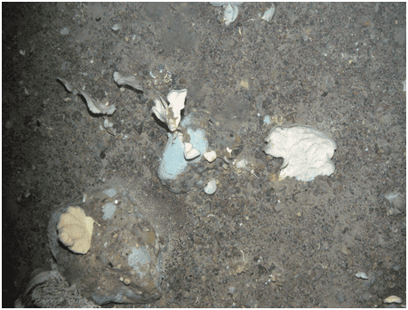
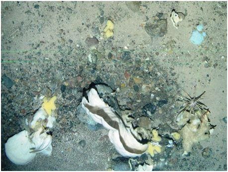
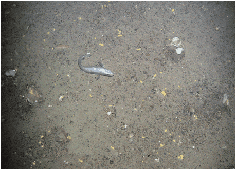
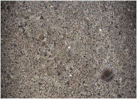
Figure 15. Feature images from Faroe-Shetland Sponge Belt MPA (© JNCC, 2012) Deep-sea sponges (a-b). Fish and pencil urchins (c) and burrowing anemone (d) on offshore subtidal sands and gravels
9.3 Site Boundary
The boundary has been set in accordance with the boundary setting principles outlined in the MPA Selection Guidelines.
The 400-800 m depth band was used for the boundary which largely reflects the range of hydrographical conditions within the Faroe-Shetland Channel. The MPA boundary encompasses all verified records of deep-sea sponge aggregations in this part of the Faroe-Shetland channel and includes the 400-600 m depth range where the habitat is typically recorded in the wider channel (Axelsson, 2003; Howell et al., 2007).
All records of ocean quahog within this part of the Faroe-Shetland Channel are included within the site boundary, along with viable examples of offshore subtidal sand and gravel habitats that are considered appropriate to support ocean quahog aggregations (Sabatini & Pizzolla, 2008). The boundary also captures the variation in benthic biological diversity in offshore subtidal sand and gravel habitats with depth highlighted by Bett (2012).
Confidence in the presence and extent of the protected features has been set out in the Data Confidence Assessment.
9.4 Conservation objectives
JNCC’s view on the overall condition of the site’s is that other all qualifying features (other than the Continental Slope) are in unfavourable condition and therefore need to be restored to favourable condition.
The Conservation Objective for the Faroe-Shetland Sponge Belt MPA is that the protected features –
- so far as already in favourable condition, remain in such condition; and
- so far as not already in favourable condition, be brought into such condition, and remain in such condition.
The full conservation advice documents can be found on the JNCC website. This includes the formal conservation advice for the site, background information and the full conservation objectives.
9.5 Pressure from demersal mobile fishing gear
Evidence suggests that ocean quahog can be caught or damaged by beam trawls (Klein & Witbaard, 1993; Witbaard & Klein, 1994), with an individual pass of the gear causing around 20% mortality (Bergman & van Santbrink, 2000). This has been suggested as the cause of an observed decline in abundance over the last century in the south-eastern North Sea (Rumohr et al., 1998). A study in Dutch waters showed that ocean quahog population density was inversely related to beam trawling effort (Craymeersch et al., 2000).
There is some evidence that otter trawl doors may impact ocean quahogs by bringing them to the surface (Rumohr & Krost, 1991), however there is insufficient evidence to assess the mortality caused by this gear at a population level. The northern North Sea is primarily fished by otter trawls and the evidence for ocean quahog decline is very limited compared to southern areas.
No evidence was found on the effects of shellfish dredging. However, the physical effects of scallop dredging on seabed sediments are similar to those of beam trawls (penetration to depths >5 cm) and so the effects on ocean quahog are likely to be similar. Hydraulic gears penetrate sediments more deeply than other gears and so could be expected to cause a greater mortality, particularly where ocean quahog is the target species (although there is no known direct exploitation of the species in UK waters).
Studies on deep-sea sponge aggregations have found that trawling damages, displaces and removes sponges through direct physical impact, as well as from disturbed sediment resettling and causing smothering beyond the path of the trawl itself (ICES, 2007; ICES 2010; OSPAR, 2010b). Deep-sea sponges have some capacity for recovery from mild damage, but significant disturbance, damage or smothering may result in sponges being unlikely to survive (ICES, 2007; ICES 2010).
In general, the impact of demersal mobile gear on sand and gravel sediments is relatively well understood. In high energy locations (i.e. of wave and/or tide exposed) the associated fauna tend to be well adapted to disturbance and as a result are more tolerant of fishing-related disturbance (Dernie et al., 2003; Hiddink et al., 2006).
In lower energy locations, such as muddy sands and sand in deep water, sediments tend to be more stable and their associated fauna less tolerant of disturbance (Hiddink et al., 2006; Kaiser et al., 2006). Stable gravels often support a ‘turf’ of fragile species which are easily damaged by trawling and recover slowly (Collie et al., 2005; Foden et al., 2010). Trawling and dredging tends to cause increased mortality of fragile and long-lived species and favour opportunistic, disturbance-tolerant species (Eleftheriou & Robertson, 1992; Bergman & van Santbrink, 2000). Some particularly sensitive species may disappear entirely (Bergman & van Santbrink, 2000). The net result is benthic communities modified to varying degrees relative to the un-impacted state (Bergman & van Santbrink, 2000; Kaiser et al., 2006).
9.6 Pressure from demersal static fishing gear
Static gears do not generally create the type of pressures to which ocean quahog aggregations are sensitive (sub-surface abrasion) and so they are unlikely to have any effect. Offshore subtidal sands and gravels are not considered sensitive to static gear activity.
The deep-sea sponge aggregation feature is considered to be sensitive to static gear activity, notably because sponges may become caught or entangled in static gears and damaged on the seabed or brought to the surface. In certain conditions, for example during retrieval, static gears may move laterally across the seabed resulting in impacts (Sampio et al,. 2012; Ewing and Kilpatrick, 2014). By-catch by longliners of hexactinellid and demospongid sponges has been documented within the Northeast Atlantic (Muñoz et al., 2011) and in the Antarctic (Bowden, 2010). While the extent of damage caused by individual static gear fishing events is likely to be lower than that for trawling (Pham et al., 2014), the effect of cumulative damage may be significant.
9.7 Levels of fisheries management considered
Table 12 provides a summary of the fisheries management advice set out against the various options that have been considered.
The continental slope and geodiversity features (excluding the iceberg ploughmarks) are all considered to have a low sensitivity to the pressures associated with marine activities taking place within the MPA. Consequently, JNCC consider there is no significant risk to the features achieving their conservation objectives and so the features have not been considered further in the context of the management options presented below.
(Table 12) Summary of fisheries management advice for Faroe-Shetland Sponge Belt MPA
Fisheries management options considered for demersal mobile gears
No additional management: There is a risk of not achieving the conservation objectives for offshore subtidal sands and gravels and ocean quahog aggregations. The conservation objective would not be achieved for deep-sea sponge aggregations and JNCC recommend that this level of management should not be applied in areas where deep-sea sponge aggregations occur (depths between 400 and 600 m).
Reduce / limit pressures: This level of management would reduce, but not entirely eliminate, the risk of not achieving the conservation objectives for ocean quahog aggregations and offshore subtidal sands and gravels. Appropriate management for ocean quahog could include restrictions on those gears considered to impact the species, such as scallop and hydraulic dredging. Appropriate management for offshore subtidal sands and gravels could include a zoned approach where management measures are introduced to protect specific depth corridors representative of the range of sedimentary communities on the continental slope. There may be a greater requirement for restrictions on gears that penetrate deeply into the sediment. Restrictions could be permanent in some cases or temporary/adaptive in others. The conservation objective would not be achieved for deep-sea sponge aggregations and JNCC recommend that this level of management should not be applied in areas where deep-sea sponge aggregations occur.
Remove / avoid pressures: This level of management would reduce the risk of not achieving the conservation objectives for ocean quahog aggregations and offshore subtidal sands and gravels to the lowest possible levels. This is the only option that would allow the conservation objective to be achieved for deep-sea sponge aggregations and JNCC recommend this level of management is applied to those areas where deep-sea sponge aggregations occur.
Fisheries management options considered for demersal static gears
No additional management: This level of management for demersal static gear is considered to be sufficient to achieve the conservation objectives for ocean quahog aggregations and offshore subtidal sands and gravels. The conservation objective would not be achieved for deep-sea sponge aggregations and JNCC recommend that this level of management should not be applied in areas where deep-sea sponge aggregations occur.
Remove / avoid pressures: This is the only option that would achieve the conservation objective for deep-sea sponge aggregations and JNCC recommend that this level of management is applied in those areas where deep-sea sponge aggregations occur.
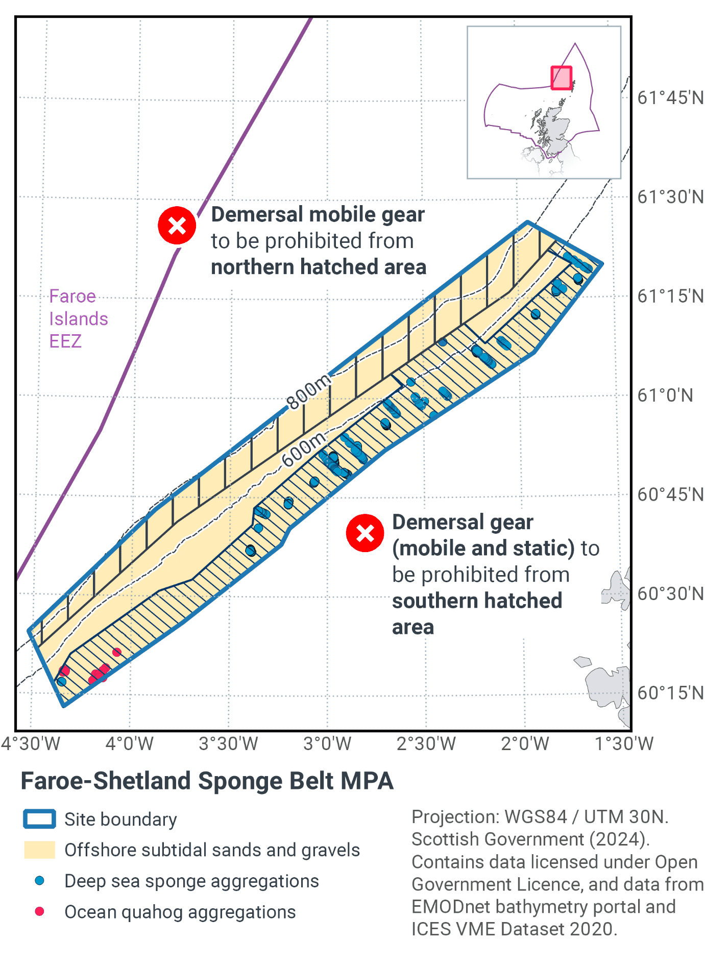
9.8 Proposed fisheries management and rationale
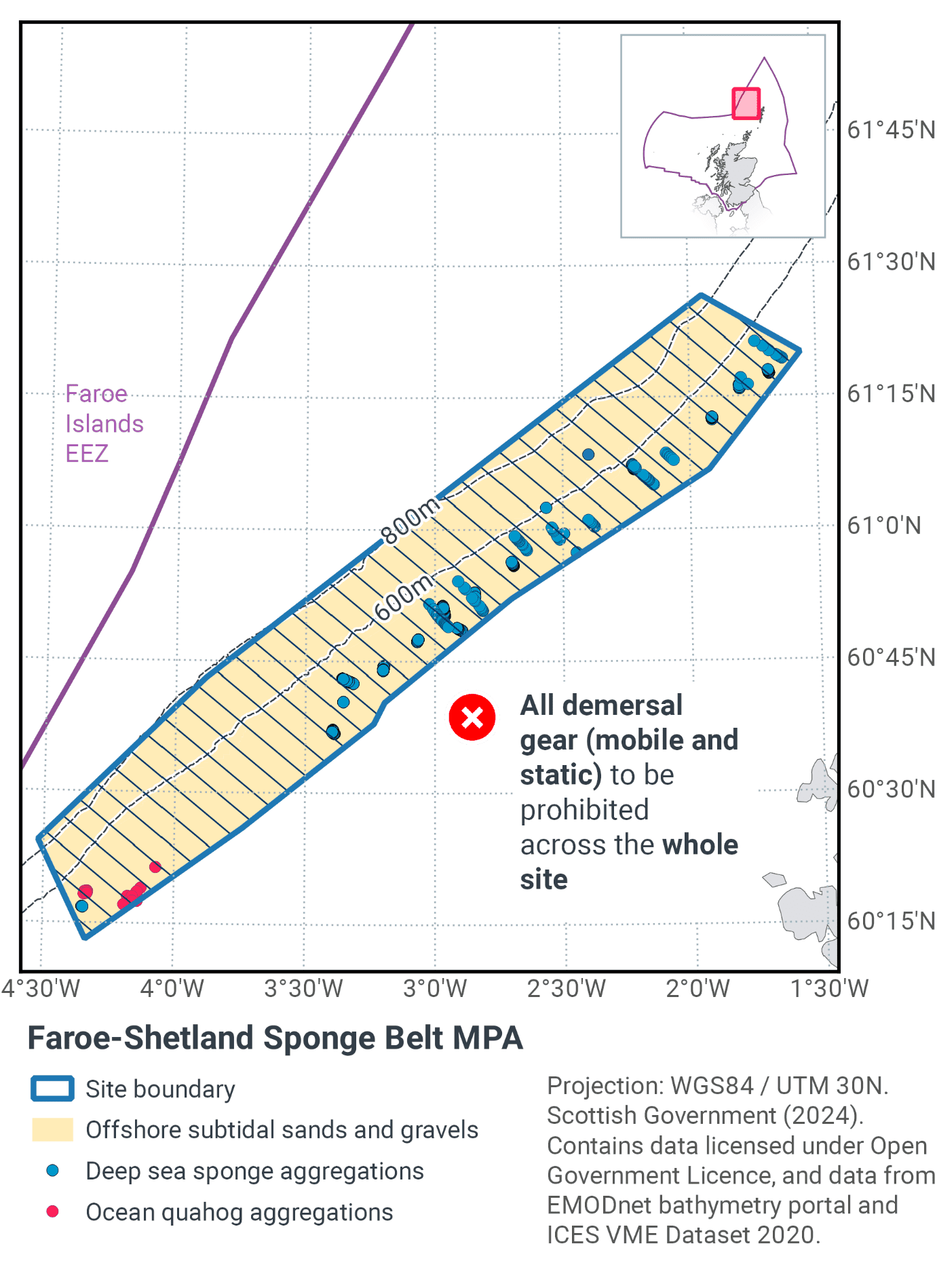
Table 13 and Figure 16 provides details of the proposed fisheries management approach and further explanation is provided below. Figure 17 shows the proposed fisheries management for full site prohibitions.
Protected feature |
Gear type |
Proposed management |
Measures |
|---|---|---|---|
Deep-sea sponge aggregations |
Demersal mobile |
Remove / avoid pressure |
Use of demersal mobile and demersal static gears to be prohibited in the part of the site where known records of deep-sea sponge aggregations are found. |
Demersal static |
Remove / avoid pressures |
||
Offshore subtidal sands and gravels |
Demersal mobile |
Reduce / limit pressure |
A proportion of this feature will be protected due to measures imposed for deep-sea sponge and ocean quahog features. To represent all components of the sands and gravels feature within the site, an additional restriction area is also proposed in deeper water. |
Ocean quahog aggregations |
Demersal mobile |
Remove / avoid pressure |
Available ocean quahog records overlap with those for deep-sea sponges within the site and as such protection is provided by the measures proposed. |
Deep-sea sponge aggregations are considered to be a VME and also listed by OSPAR as threatened and/or declining habitat or species in the Northeast Atlantic. They are sensitive to impact from all demersal fishing types. Therefore, there is no alternative to excluding all of these fishing methods from that part of the MPA. This approach also protects the ocean quahog aggregations which are also listed by OSPAR as a threatened and/or declining species in the North Sea. Therefore, the measures will be a contribution to recovery of these OSPAR listed features. They should also further progress towards Good Environmental Status in the Greater North Sea, particularly in relation to Descriptors 1 (biological diversity) and 6 (sea-floor integrity).
To ensure representation of communities associated with offshore subtidal sand and gravel in deeper waters within the site, the advice is to reduce or limit pressure. As there is no significant activity in this area currently, the preference is to prevent pressure being exerted in the future. Crucially, from a fisheries perspective, this approach enables demersal trawl gear to still be used in a relatively small but productive part of the MPA while also reducing the risk to the protected features.
Contact
Email: marine_biodiversity@gov.scot
There is a problem
Thanks for your feedback