Fisheries Management Measures within Scottish Offshore Marine Protected Areas (MPAs) - Strategic Environmental Assessment Environmental Report
This assessment is undertaken to identify and assess any likely environmental effects of the policy and its alternatives.
Environmental Baseline
Introduction
This section of the Environmental Report describes the character of the environment which may be affected by the offshore MPA fisheries management measures. The focus of this baseline information is, therefore, on Biodiversity, Flora and Fauna; Soil (geodiversity); Water (the environmental status of the marine region under the UK Marine Strategy Regulations); and Climatic Factors (carbon cycling, storage and sequestration), reflecting the scope of the assessment as described in Section 3.3.
Scotland’s offshore waters cover a sea area of 462,263km2. The seas around Scotland contain a wide variety of habitats and species. This diversity is due in part to the geographic position of Scotland, with influences from warm Gulf Stream waters in the west and cooler waters from the Arctic in the north and east[60].
Biodiversity, flora and fauna
Scotland’s marine environment supports a diverse complex of different habitats, which in turn support a wide range of marine plants and animals. Estimates suggest there are around 6,500 species of animals and plants (excluding microbial flora and seabirds) in Scotland’s seas[61].
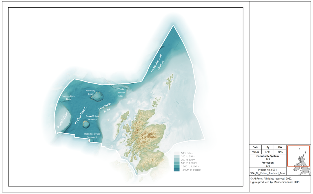
Scotland’s deep sea is characterised by soft sediments, steep submarine ridges (Rockall Bank) and seamounts (Rosemary Bank). The interaction between deep-ocean currents and these topographically distinct features provide ideal habitat for vulnerable and slow growing species[62].
Offshore marine habitats
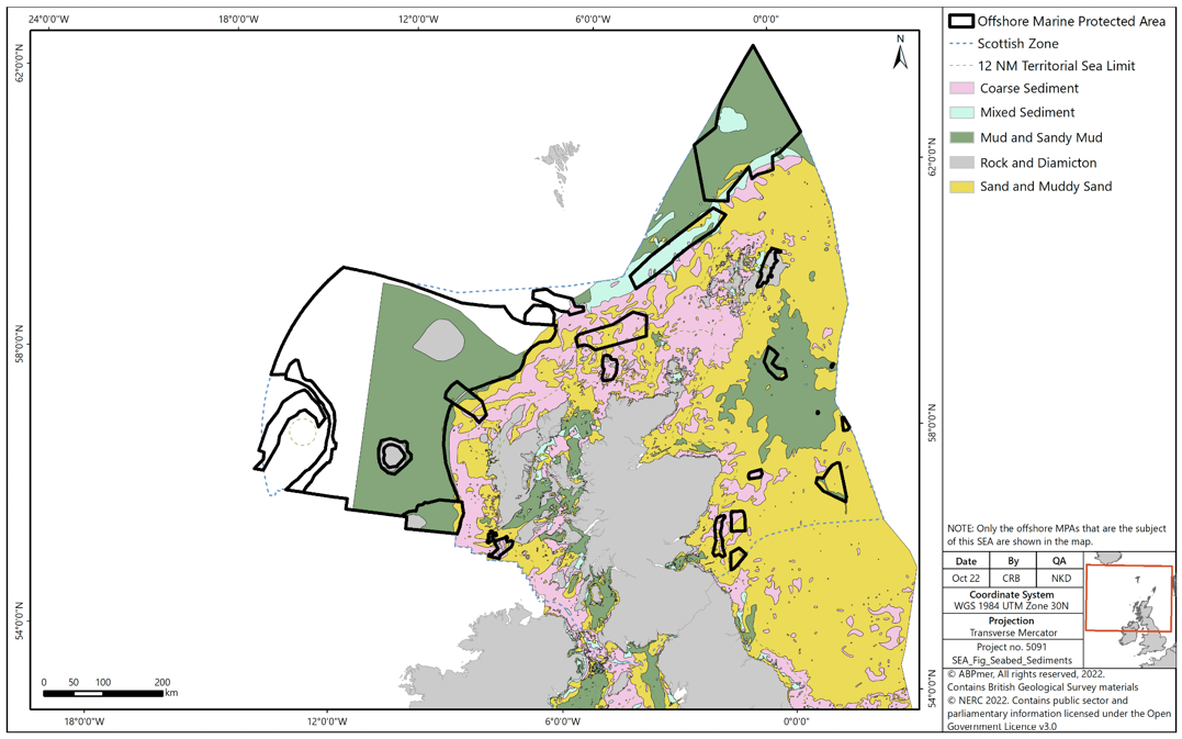
The offshore marine habitats present within the study area can be generally characterised as mud, sand and coarse sediment, with small areas of rock in the North Sea, to the west of the Hebrides and in the north of Scotland. The seabed in the far west and north of Scotland is mainly characterised by mud and fine clay, with coarser sediments in shallower water and on banks and seamounts, and small areas of rock and hard substrate[63].
The information presented in Figure 2 on predicted seabed habitats is provided by National Marine Plan Interactive (NMPi) and European Marine Observation and Data Network (EMODnet) Seabed Habitats. The layer is a predictive European Nature Information System (EUNIS) seabed habitat map for the UK continental shelf, which has been created using five pre-processed input datasets: substrate, biological zone, energy, salinity and biogeographic region.
Offshore circalittoral mud, offshore circalittoral sand, upper bathyal sediment and offshore circalittoral coarse sediment can be found in large patches throughout offshore waters of Scotland.
To the far north of Scotland in the northern and deeper Norwegian basin area, the substrates are dominated by muds and an area of mixed sediments. As the Channel narrows toward the Wyville-Thomson Ridge the substrate changes with increasing particle size to sandy muds and muddy sands, through sands to mixed and coarse sediments. Sands and coarse sediments occur along the southern edge of the Faroe-Shetland Channel.
To the far west of Scotland, the substrate type along the Hebridean Slope comprises a mixture of mud, sandy muds and muddy sands with occasional coarser sediments on the upper slope. A larger area of sand and coarse sediment exists toward the Darwin Mounds and Wyville-Thomson Ridge. West of the Hebridean Slope the low energy and deep-water environment of the Rockall Trough results in the vast majority of the area being sandy-mud and muddy-sand habitat, with sands and coarser sediments being located around the larger geological features such as seamounts and banks and within the narrow channel between the George Bligh Bank and East Rockall Bank. North of the George Bligh Bank, bands of mixed and coarse sediments are predicted to be present.
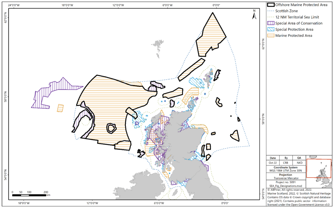
Within Scottish waters, deep-sea habitats are found almost exclusively to the west and north of Scotland and include cold-water coral reefs, aggregations of deep-sea sponges, sea-pens, coral carbonate mounds, submarine canyons, sea mounts and deep-sea sediments[64],[65]. There is also some (> 2000 m water depth) abyssal plain habitat within Scottish waters.
Benthic habitats in the deep-sea support a considerable biomass and are considered to be the largest ecosystem on earth[66]. However, ecological information is sparse for deep-sea habitats for all but a few species[67].
Deep-sea habitats, including Scotland’s seamounts, provide refuge, nursery and feeding grounds for once commercially valuable species, such as orange roughy (Hoplostethus atlanticus), which are now in decline due to over-fishing. Deep-sea environments are also of conservation interest for species such as deep-sea skate (Bathyraja richardsoni), which utilise seamounts to deposit eggs[68].
Collectively, carbonate mound communities, cold-water coral reefs, coral gardens, deep-sea sponge aggregations and seamount communities that characterise Scotland’s deep sea have been categorised as Vulnerable Marine Ecosystems (VMEs). These features are considered under threat and subject to decline[69].
Mobile species
Scotland’s marine environment supports a wide range of mobile species with several populations considered to be either of international or national importance. Several mobile species within Scottish waters are already protected through designation or classification of areas within Scottish waters or around Scottish coastlines, some of which overlap with MPAs, as discussed below under ‘Protected habitats and species’. Mobile species in Scottish waters include the following groups:
- Seals (grey and harbour seals);
- Cetaceans (27[70] species have been recorded in Scottish waters over the last 25 years; of these, 11 are regularly sighted);
- Birds (both breeding seabirds and overwintering waterbirds);
- Fish, including sharks, rays and skates; and
- European otter.
Otters will have little interaction with the offshore environment and are, therefore, not described further.
Figure 2 Seabed habitats in Scottish waters [Full key is provided below figure]
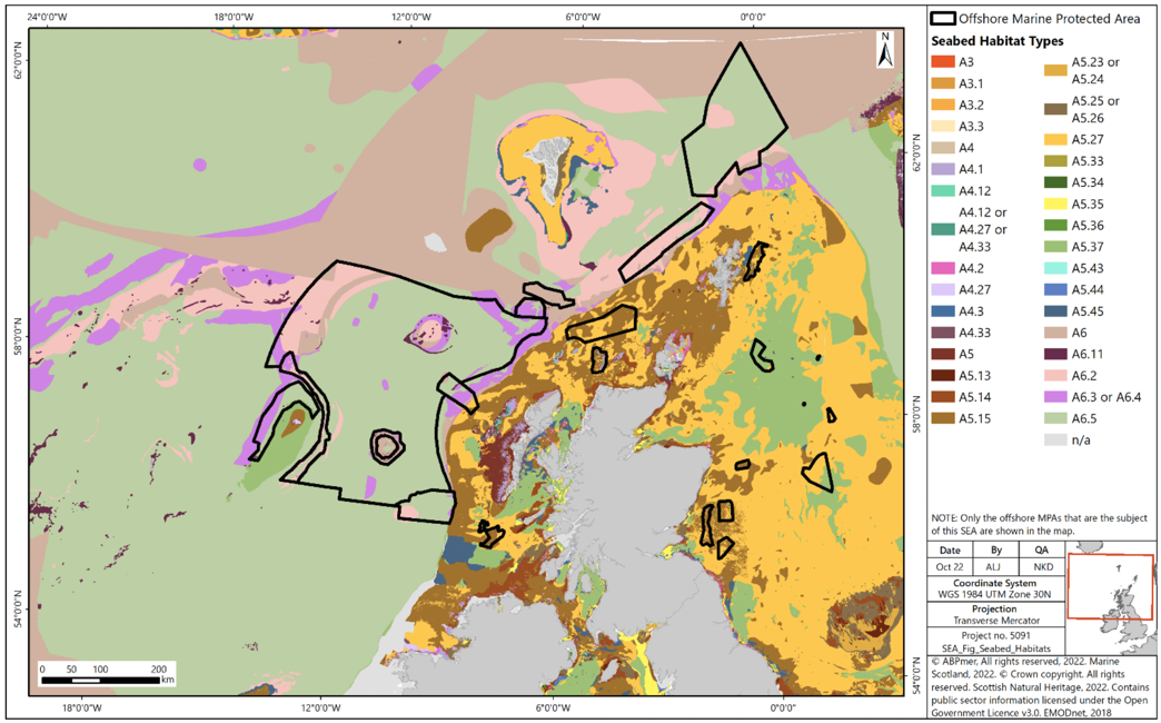
Key for Figure 2.
Marine Mammals (cetaceans and seals)
Marine mammals are widely distributed around Scotland. Species distributions are a function of prey availability and habitat distribution. They occur all around Scotland, but the greatest diversity can be found off the continental shelf waters to the north and west[71]. Eleven species of cetacean are regularly sighted around Scottish seas. These comprise species with important resident populations, such as bottlenose dolphin, alongside more migratory species passing through Scottish seas, such as sperm whale. Key marine mammal species in Scottish seas include:
- Grey seal;
- Harbour seal;
- Harbour porpoise;
- Bottlenose dolphin;
- White-beaked dolphin;
- Fin whale;
- Minke whale;
- Short-beaked common dolphin;
- Atlantic white-sided dolphin;
- Risso’s dolphin;
- Long-finned pilot whale;
- Killer whale; and
- Sperm whale.
As cetaceans are highly mobile, it is not possible to assess changes in the dominant species at a Scottish Marine Region scale and, therefore, changes in abundance are reported at a smaller scale e.g. the European Continental Shelf[72].
Information regarding cetaceans in the deep-sea is limited, although some species present in Scottish waters are known to dive to significant depths and could, therefore, have some interaction with the seabed in the offshore environment. For example, it is known that most migrating individuals of humpback whales remain in deep water off the continental shelf[73], with increasing records year on year[74]. However, the current understanding of the interaction of cetaceans in offshore waters is limited.
Grey and harbour seals breed around the Scottish coast and forage in Scottish waters. As seals are long-lived predators whose populations can be readily monitored when they are on land, this makes them useful indicators of the health of seas around Scotland[75].
Fish
There are a number of fish species present in the offshore waters of Scotland. The International Bottom Trawl Survey identified 167 different species in the seas around Scotland, including a range of non-commercial and commercial species (e.g. mackerel, herring, haddock, monkfish, cod, hake, whiting and saithe)[76]. JNCC has reviewed literature available on eleven species of fish regarded as potential features of designation interest and present in the deep waters to the west and north of Scotland[77].
Three species, the gulper shark, Atlantic halibut and orange roughy are very rarely encountered in surveys. The gulper shark is of uncertain status. This is the southern limit of the Greenland halibut which probably only occurs in the Faroe-Shetland channel and further north. Fisheries for porbeagle shark, spurdog, leafscale gulper shark and Portuguese dogfish are all prohibited. The round-nose grenadier, blue ling, anglerfish and Greenland halibut are fished commercially within total allowable catch (TAC) limits. For the roundnose grenadier, blue ling, anglerfish and orange roughy, deep-sea Scottish offshore waters provide important areas for spawning and may be of critical importance as a source of juveniles within the area and for surrounding seas. The offshore waters of Scotland contain distinctive habitat for endangered species of deep-sea sharks, the gulper sharks and Portuguese dogfish. Of the species included here, the gulper shark, leafscale gulper shark, Portuguese dogfish and orange roughy are included in the OSPAR list of threatened and declining species and habitats[78].
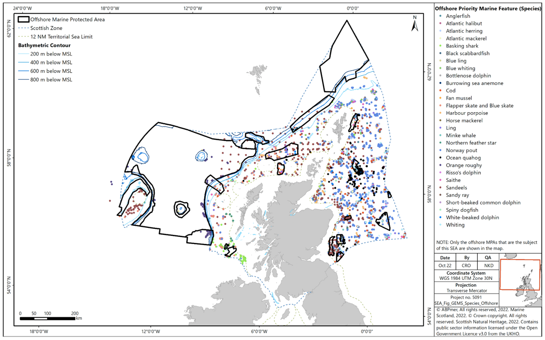
A number of fish, sharks, skates and rays have been recorded in Scottish waters[79]. Fish which are known to use the offshore area and are also designated as PMFs include anglerfish, Atlantic halibut, Atlantic herring, black scabbardfish, blue ling, blue whiting, cod, European hake, Greenland halibut, horse mackerel, ling, leafscale gulper shark, Norway pout, orange roughy, porbeagle shark, Portuguese dogfish, round-nose grenadier, saithe, sandeel and whiting[80].
Sharks and rays which are known to use the offshore marine area include the basking shark, sandy ray, thresher shark and blackmouth catshark[81]. The basking shark is a PMF which migrates over large distances in both Scottish offshore and coastal waters at depths from the surface to over 750m. They are particularly associated with tidal fronts on the continental shelf and shelf edge where they feed on plankton. The sandy ray is a PMF, which occurs at depths from 70 to 275m, and is typically found on sandy or muddy sea beds to the north-west of Scotland. The thresher shark is typically found 40 to 75 miles offshore and is considered rare in Scottish waters. The blackmouth catshark is found throughout Scottish waters but is more abundant in deeper offshore waters.
Rockall Bank is an example of an offshore area where fish species have been commercially exploited, indicating a presence of monkfish, black scabbardfish, torsk, ling, argentines, blue ling, roundnose grenadier, orange roughy, deep-water sharks and Portuguese dogfish[82].
Birds
Scottish offshore waters are important for marine birds, namely seabirds[83]. Seabirds respond to a range of factors, such as changes in food availability, weather, predation and pollution.
Scotland’s seabirds are of international importance, with 24 species regularly breeding in Scotland. Of these, Scotland hosts 56% of the world’s breeding population of great skua, 16% of the world’s Manx shearwater and 20% of the world’s northern gannet. Within Europe, Scotland also has 12% of the continent’s northern fulmar, 11% of black-legged kittiwake and 43% of Europe’s common guillemot. For many other species, Scotland holds between 1 and 10% of the European breeding population[84].
The highly pathogenic avian influenza (HPAI) virus H5N1 is circulating widely within wild bird populations in Scotland[85]. The situation is rapidly evolving and there is concern about the impact of HPAI on vulnerable bird species, including seabirds. The outbreak has already resulted in significant declines in northern gannet and great skua[86].
Protected sites
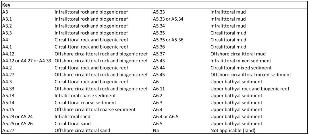
The importance of Scotland’s marine ecosystems is reflected in the range of designations which protect them at the international and national levels. All designations are included and incorporated into Scotland’s MPA network, covering approximately 37% of Scottish seas[87]. The current designations in Scottish inshore and offshore waters are:
- Special Areas of Conservation (SAC): These include both inshore and offshore SAC and a number of different marine habitat types which occur in offshore waters (Annex I reef: stony, bedrock and biogenic reef; submarine structures made by leaking gases; and submerged or partially submerged sea caves). Marine species that occur in offshore waters are also protected (bottlenose dolphin, harbour porpoise, grey seal, harbour seal, sea lamprey and Atlantic salmon);
- Special Protection Areas (SPAs): These protect and are of international importance for a number of bird species (e.g., seabirds and some seaducks); and
- Nature Conservation MPAs (NCMPAs): These protect habitats and species, including a range of offshore habitats and species (Annex I reef; burrowed mud; cold-water coral reefs; coral gardens; deep-sea sponge aggregations; ocean quahog aggregations; offshore deep-sea muds; offshore subtidal sands and gravels; sandeels; and seamount communities).
Existing and proposed SACs
Existing and proposed SACs, SPAs and NCMPAs are shown in Figure 4.
There are 58 SACs with marine components in Scotland, 47 of which are in inshore waters[88], nine are completely in offshore waters[89], and a further two sites which have parts in both inshore and offshore waters.
Scotland currently has 56 marine SPAs with marine or coastal components, 53 of which are wholly within Scottish inshore waters and three which overlap both inshore and offshore waters.
The Scottish Government has designated 36 NCMPAs, 13 of which are offshore[90]. There is also a Demonstration and Research MPA around Fair Isle[91].
There are 65 SSSIs[92] with marine components in Scotland. These include land and the foreshore generally only down to mean low water spring tide level.
There are also 51 Ramsar sites in Scotland designated as internationally important wetlands, covering a total area of about 326,719 hectares[93], of which 16 form part of the MPA network[94].
The Habitats Regulations[95] as amended by the Conservation of Habitats and Species (Amendment) (EU Exit) Regulations 2019[96],[97] also affords protection to certain species of plants and animals (European Protected Species). In the marine environment these include cetaceans and otters.
Priority marine features
In July 2014, Scottish Ministers adopted a list of 81 PMFs. PMFs are species and habitats which have been identified as being of conservation importance to Scotland[98]. Most are a subset of species and habitats identified on national, UK or international lists. The National Marine Plan includes a policy (GEN 9 Natural Heritage) for safeguarding PMFs whereby ‘Development and use of the marine environment must not result in significant impact on the national status of PMFs’[99].
The list of 81 PMFs comprises 26 broadscale habitats (e.g., burrowed mud), seven low or limited mobility species (e.g., ocean quahog) and 48 mobile species, including fish (e.g., blue ling) and marine mammals (e.g., minke whale).
Available PMF data relevant to the offshore waters of Scotland are presented in Figure 4 and Figure 5. The information has been collated in a computer database called GeMS (Geodatabase for Marine Habitats and Species adjacent to Scotland) and has contributed to the Scottish MPA process[100].
Trends and pressures
Within the marine environment there are a number of pressures on biodiversity, flora and fauna. Scotland’s Marine Atlas presented an assessment of the condition of Scotland’s seas and a summary of significant pressures and the impacts of human activity[101]. It was based on scientific evidence from available data and analysis, supported by expert judgement and taking account of key data gaps[102].
The Marine Atlas reviewed the condition of major seabed habitat types in Scottish waters. In terms of offshore habitats, there were few or no concerns about subtidal rock. There were also some concerns about the effects of trawling on deep-sea habitat, although such activity has since been banned at depths greater than 800 m. Vulnerable marine ecosystems are also closed to bottom gear fishing at depths greater than 400 m.
There are a number of current and future pressures on marine biodiversity, flora and fauna in the deep-sea, such as loss and/or damage of habitat and species, and climate change. The Feature Activity Sensitivity Tool (FEAST) provides comprehensive information on the relevant pressures associated with a range of marine activities and the sensitivity of MPA protected features to these activities and pressures[103]. The JNCC has more recently compiled an activities-pressures matrix comprising 39 human use activity categories and 34 human pressure types. The matrix provides a comprehensive evidence base for understanding the relationships between these human activities and pressures within the marine environment[104].
Geodiversity
Seafloor geodiversity
Geodiversity is defined as the natural range (diversity) of geological features (rocks, minerals and fossils), geomorphological features (landforms and processes) and soil features that make up the landscape both on land and below water. The condition of underlying geodiversity features such as sand banks and seabed influence the quality of habitats which in turn affects the viability and health of both flora and fauna populations.
There are six protected features of Scottish geodiversity that are protected by NCMPAs:
- Quaternary of Scotland;
- Submarine Mass Movement;
- Marine Geomorphology of the Scottish Deep Ocean Seabed;
- Seabed Fluid and Gas Seep;
- Cenozoic Structures of the Atlantic Margin; and
- Marine Geomorphology of the Scottish Shelf Seabed.
Each feature is in turn comprised of a variety of components, such as continental slope channels, iceberg ploughmark fields, moraines, slide deposits, sand wave fields, pockmarks, seamounts, sand banks and mega-scale glacial lineation. Major physiographical features of the Scottish marine environment are shown in Figure 6.
Data from the British Geological Society (BGS) indicates that Scottish waters have a wide range of seabed habitats, ranging from scoured rock or coarse sediment to muddy gravel or fine sand in some areas (Figure 7). A description of the key habitat types in Scottish waters is provided in the section on ‘Offshore Marine Habitats’ above.
In general, marine sediments are sandy or gravelly and originate from deposits from the Quaternary glaciation. Muddy sediments occur principally nearshore or, further offshore, in depressions on the sea floor, where currents may be relatively weak, particularly to the east of Scotland. They also occur beyond the shelf break (200 m water depth) to the west of Scotland. The concentration of calcareous material varies greatly in seabed sediments, reflecting the amount of shell material in different areas, and can locally be very high[105].
Throughout the west of Scotland and north-east of the Wyville-Thomson Ridge, topographic features influence the prevailing currents and consequently, the sediment types present[106],[107],[108],[109],[110]. In general, deep-sea, subsurface currents are weaker when compared with surface flows but are intensified around topographic features such as seamounts, the continental slope and the Rockall Bank[111],[112]. In deeper areas, away from large topographic features and with low or negligible currents, finer, muddy sediments are present[113]. The highly varied topography in the region of the Faroe-Shetland Channel results in complex current patterns, which in turn influence sediment distribution patterns. Within the Faroe-Shetland Channel, stronger currents are present as the channel narrows toward the Wyville-Thomson Ridge; this results in coarser sediments being located at greater depths compared with the deep-sea to the west of Scotland[114]. Low sediment deposition rates in the Faroe-Shetland Channel also play a role in determining which sediments are present[115]. Overall, there is a trend of increasing mud content from the southwest to the northeast within the Faroe-Shetland Channel. There are higher percentages of sands and gravels around such features as the Rockall Bank, the continental slope and around the Wyville Thomson Ridge.
Several geological sedimentary features exist in Scottish offshore waters. These features may take the form of slide deposits, iceberg plough marks, sediment drifts, sediment wave fields, sand contourites and barchan sand wave fields[116], mud diapirs[117] / mounds and sediment plains. Within the Faroe-Shetland Channel, including the approach to the Wyville-Thomson Ridge, Bett (2012)[118] illustrates the distribution of the known sedimentary physical features. Below 800 m these include contourite deposits, barchan sand dunes, gravel / cobble deposits, landslide debris (mud blocks) and mud diapirs and mud mounds.
Sediments along the Hebridean slope to the west of Scotland show a general decrease in grain size with increasing depth and are described as being thickest within the eastern Rockall Trough and along the Hebridean slope and thinnest in the western Rockall Trough and on the Rockall Plateau[119]. A survey to locate rocky reef features on the Rockall Bank also recorded this gradation in sediment type, identifying mud habitats at the base of the bank in ~1,100 – 1,600 m depth[120]. Along the continental slope, sediments change from sands at 700 m to silty mud and mud between 700 – 1,000 m depth with gravel patches being rare and cobbles and boulders even rarer[121]. Sediments extending into the Rockall Trough are described as being mainly mud with some areas of coarse sand and gravel[122].
Trends and pressures
Pressures on geodiversity features in Scottish seas arise from multiple activities, including renewable energy development, seafloor exploration activities, oil and gas extraction, and seafloor mining and fishing[123].
Water (environmental status of marine region)
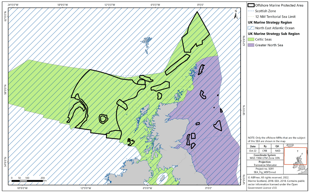
The mechanism in place for monitoring and managing the quality of Scottish offshore waters is the UK Marine Strategy Regulations. The offshore MPAs overlap with the North-East Atlantic Ocean marine region (Celtic Seas and Greater North Sea sub regions) (Figure 8).
Achieving GES under the UK Marine Strategy involves satisfying several elements (known as descriptors (D)), namely D1 biological biodiversity (cetaceans, seals, birds, fish, pelagic habitats and benthic habitats); D2 non-indigenous species; D3 commercially-exploited fish and shellfish; D4 food webs (cetaceans, seals, birds, fish and pelagic habitats); eutrophication; sea-floor integrity (pelagic habitats and benthic habitats); hydrographical conditions; contaminants; contaminants in fish and other seafood for human consumption; litter and introduction of energy, including underwater noise[124].
Trends and pressures
The updated UK Marine Strategy Part 1 published in 2019 presents the progress that has been made towards achieving GES in the North-East Atlantic Ocean marine region since the first assessment was undertaken in 2012[125]. In summary, GES has been achieved for eutrophication, changes in hydrographical conditions, contaminants, and contaminants in seafood[126]. GES has been partially achieved for cetaceans, seals, pelagic habitats, food webs and input of anthropogenic sound. GES has not been achieved for birds, fish, benthic habitats, non-indigenous species, commercial fish and shellfish, and litter.
Since 2012 environmental status has declined for birds, and has remained stable for cetaceans, pelagic habitats, benthic habitats, non-indigenous species, eutrophication, changes in hydrological conditions, litter and input of anthropogenic sound[127]. Environmental status has improved since 2012 for seals, fish, commercial fish and shellfish, food webs, contaminants, and contaminants in seafood.
There is limited data on the condition of offshore and deep-sea habitats in Scottish seas, and as such it is not possible to assess trends against relevant habitat and species group indicators.
Potential pressures against the UK Marine Strategy applicable to the offshore MPAs include increases in fishing activity, increases in oil and gas activity (and associated chemical discharges), increases in seabed extractive activities (i.e. seabed mining).
Climatic factors (specifically carbon cycling, storage and sequestration)
The term ‘carbon cycle’ refers to the circulation of carbon in the environment. In the context of this report, it focusses on the exchange of carbon between the ocean and the atmosphere. The proportion of carbon incorporated into biomass is said to be ‘stored’; thus, marine ecosystems such as kelp forests, maerl beds and marine sediments are able to store carbon. The addition of solid carbon to these long-term stocks is referred to as sequestration, and the conversion of atmospheric carbon dioxide to solid carbon in living material is referred to as fixation. The stored carbon can be released, however, through physical disturbance, bacterial decomposition of organic matter or respiratory processes within the food chain.
A significant proportion of carbon sequestration occurs through fixation during oceanic photosynthesis and the subsequent long-term storage of the produced organic material. In addition to carbon being sequestered within the oceanic sediments, a significant portion is stored within living marine organisms. These organisms include taxa that possess calcium carbonate skeletons and shells such as coral and molluscs, with other carbon captured and stored in plant dominated habitats such as seagrass beds, kelp forests and maerl.
Within the marine environment, habitats and processes capable of carbon fixation and sequestration are defined as ‘blue carbon sinks’. Multiple habitats across Scottish seas and coastal areas can be termed blue carbon sinks due to their fixation and sequestration ability. Their effectiveness as carbon sinks is highly dependent upon their long-term capacity to store carbon. Habitats present in Scottish waters and classed as blue carbon sinks are[128]:
- Kelp forests;
- Intertidal and sub-canopy macroalgae;
- Saltmarshes;
- Seagrass beds;
- Maerl beds;
- Horse mussel beds (Modiolus modiolus);
- Flame shell beds (Limaria hians);
- Lophelia pertusa reef;
- Tubeworm (Serpula vermicularis) reef;
- Blue mussel beds (Mytilus edulis);
- Brittlestar beds;
- Sediment; and
- Phytoplankton.
The largest contribution to carbon fixation and sequestration in Scottish waters comes from phytoplankton, via photosynthesis and subsequent deposition of the produced organic matter in seabed sediments. This may occur either directly through the export of phytoplankton or indirectly through the consumption of phytoplankton by other organisms and subsequent export of this organic matter through the food chain[129].
Carbon stored in shallow shelf sediment tends to be ephemeral and constantly exchanged due to the dynamic nature of such habitats. Therefore, the potential for shallow shelf sediments to provide long term carbon storage is a function of sedimentation rates and the degree of recycling of organic carbon. The rate of recycling of organic carbon is driven by the level of oxygen available for bacterial and chemical breakdown of organic matter[130], which is primarily influenced by disturbance of seabed sediments and the oxygen content of the seawater above the seabed.
Research to date on the function of the marine environment in carbon cycling, storage and sequestration has primarily focussed on inshore habitats. Deeper offshore sediments which are the subject of this SEA are less mobile and dynamic and, therefore, are expected to be able to store carbon to a greater extent, but the rate of uptake into the sediment is likely to slower as sedimentation rates in deeper waters are reduced.
Trends and pressures
Shelf seas around the UK are predicted to be 1°C to 4°C warmer by the end of the 21st century[131]. Warmer sea temperatures could result in a shift in distribution of certain habitats and species and both biodiversity and benthic biomass in the deep oceans are predicted to decrease as a result of climate change[132]. This additional warmth will, eventually, also be circulated and lead to warmer conditions in the deep oceans, having potentially similar impacts on biodiversity features to those seen in shallower waters.
An increase in atmospheric carbon dioxide will lead to a subsequent increase in dissolved CO2 concentrations within the ocean, increasing ocean acidity. This has the potential to hinder calcium carbonate producing organisms and, therefore, their ability to sequester carbon in the long term.
Calcifying organisms such as pelagic gastropods, bivalves and corals may be particularly affected[133]. For example cold-water corals found in deep waters, such as the Darwin Mounds to the north-east of Rockall, may also be particularly sensitive to decreases in pH and concentration of carbonate ions. These coral colonies serve as shelter, feeding and breeding habitats for a wide range of species including commercial fish[134].
In addition, following mortality of such organisms, there is increased potential for carbonate shells or skeletons to dissolve faster, in both shallow shelf seas and deeper ecosystems, and, therefore, recycle greater amounts of carbon before they can be sequestered in seabed sediments. This pathway is particularly significant where the carbonate pump forms a considerable portion of the carbon export to deep-sea sediments.
Climate change has also resulted in changes in the mean state of the North Atlantic Oscillation (NAO) which has led to alterations in water current strength and circulation in the North Atlantic. This has resulted in negative impacts on the dispersal and settlement of the cold-water coral larvae. Furthermore, models working under high emissions scenarios predict a decrease in seafloor habitat suitability for cold-water corals in the North Atlantic, with a large percentage of features predicted to be exposed to increasingly acidic waters[135].
The increased frequency of severe storm events that will result from climate change has the potential to affect the carbon storage and sequestration capacity of inshore marine habitats as a result of the wave scour damage and subsequent resuspension. Conversely, storm events in offshore waters are unlikely to influence deep sea habitats due to the greater water depths.
Several methods of fishing, deep-sea mining and oil and gas activities physically disturb the seafloor. As previously stated, any physical damage caused to a habitat has the potential to disturb, remove or release any carbon held within that store. However, it may also increase other nutrient levels, which could in turn increase the levels of primary production. The level of impact will depend on the specific area affected. For example, the trawling of ephemeral, gravelly areas will release negligible amounts of carbon, but a trawl across deep-sea carbon rich sediments may have greater impacts. In general, direct pressure from fishing activity has the potential to affect how Scotland’s marine environments regulate atmospheric carbon levels.
Contact
Email: marine_biodiversity@gov.scot
There is a problem
Thanks for your feedback