Flood Resilience Strategy: case studies
Examples of diverse initiatives around Scotland that are in some way contributing to our flood resilience.
Theme One - People
Case Study 1: Alva Community Resilience Team - Improving flood resilience within communities
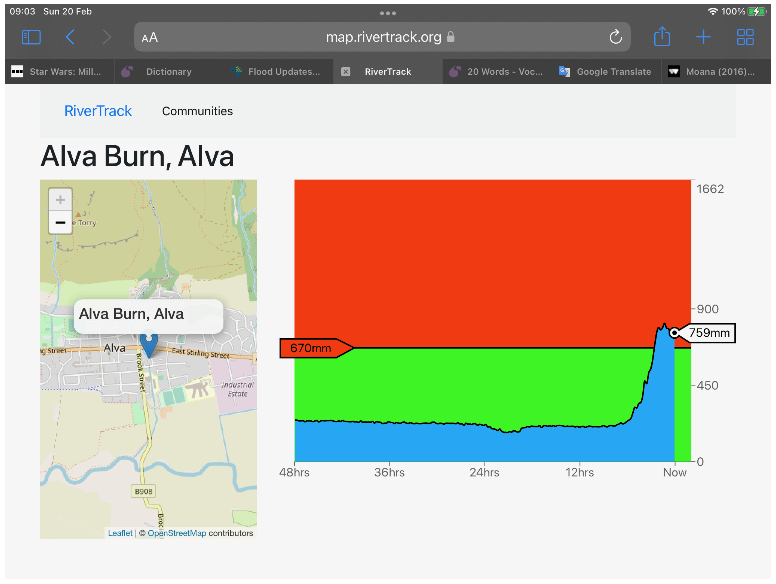
Image provided by Alva Community Resilience Team
The communities along the Hillfoots in Clackmannanshire sit at the foot of the Ochil Hills. Several tributaries of the River Devon flow through these villages and towns, with each community facing their own unique challenges, therefore local knowledge was key to response planning. The Alva Community Resilience team was set up in early 2020, replicating other established groups in the area, such groups in Menstrie and Tillicoultry Coalsnaughton and Devonside (TIDECO) communities, to prepare for and adapt to the threat of flooding.
To allow the group to respond quickly to any incidents, the Council has placed a number of flood pods at strategic points around the town. These are small cabinets, similar to telecoms street cabinets, secured with a combination padlock. The contents of each pod vary due to the location but typically might include water activated flood snakes or sandbags and tool, which are replenished by Clackmannanshire Council.
As the Alva Burn can be a particular area of concern, a monitoring system called RiverTrack was installed. This consists of a monitoring sensor that records the level of the Alva Burn and updates every 15 minutes on the level of the burn. If the burn level reaches, or exceeds a set level, it will trigger an alarm. Along with the RiverTrack system, the Council purchased two flexible flood barriers. These can be rolled up and stored in a nearby flood pod, and when required rolled out to form barriers. As these barriers would need to be placed across a road, permission was negotiated by the Council with Police Scotland that, in the event that these barriers need deployed, the road can be closed, and the police are informed by a phone call.
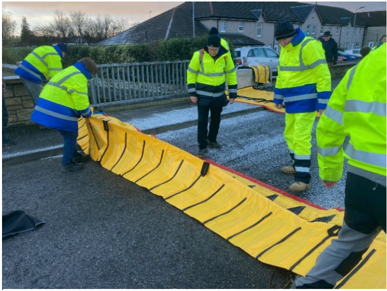
Image provided by Alva Community Resilience Team
Weather forecasting from various sources are also monitored by the group to identify any potential issues, including Flood Alerts and the Scottish Flood Forecast issued by SEPA. The group also assists by removing debris which can caused blockages in watercourses and reporting any blocked road gullies.
Whilst public liability insurance is not a legal requirement for community activities, it can provide a safety net and reassurance for community groups to move forward with their activities. Information about insurance is accessible and may already be provided by Community Councils or under each individuals’ household or motor cover.
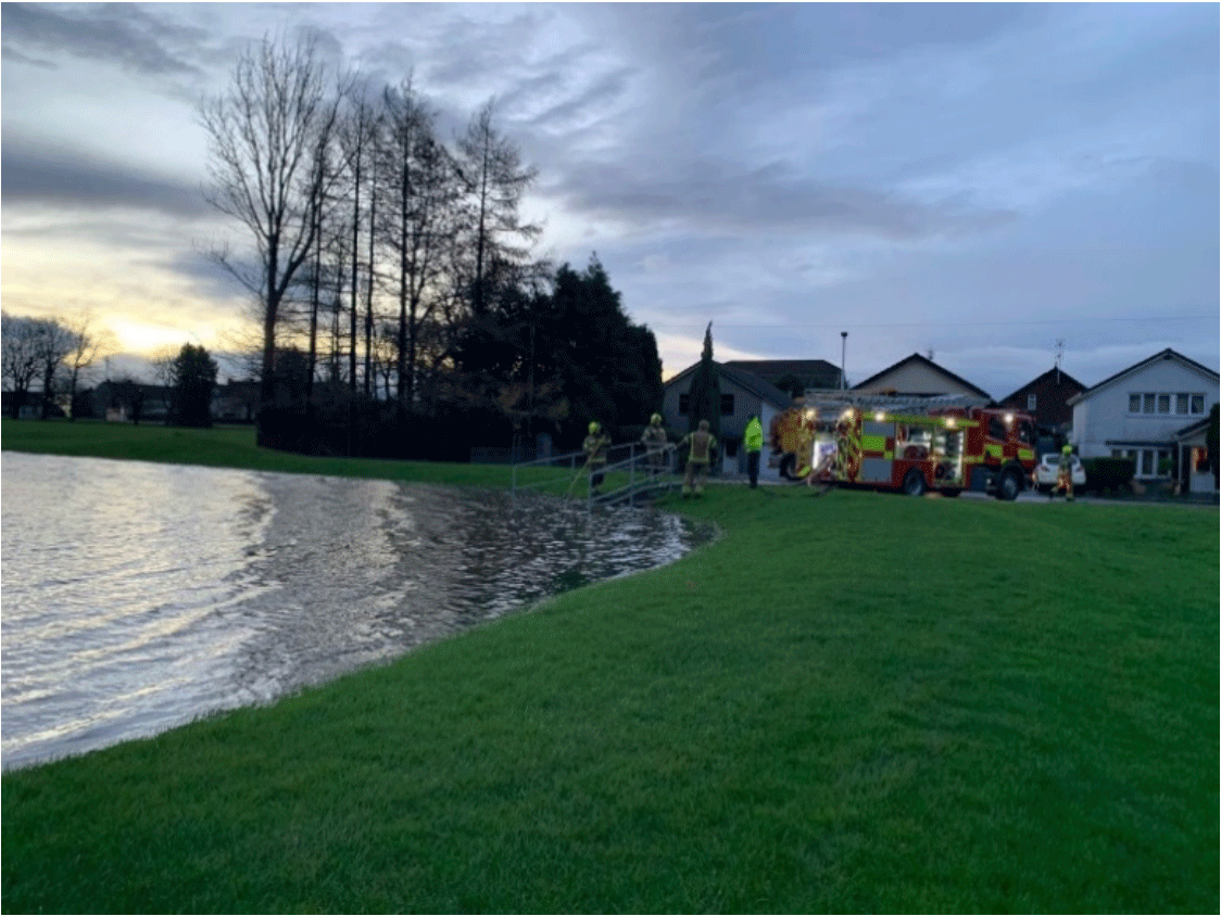
Image provided by Alva Community Resilience Team
Case Study 2: Tillicoultry Flood Group – Empowering communities to make changes locally
In January 2008, following days of heavy rain, the River Devon burst its banks and quickly flooded 17 homes and a commercial property in Tillicoultry, Clackmannanshire. The impact on residents was devastating, losing their homes and community in a matter of minutes and being relocated to temporary accommodation for up to 9 months until their homes were dried out and reinstated.
In response, Tillicoultry residents formed a Flood Group and worked closely with Clackmannanshire Council and the Scottish Flood Forum to identify flood risks and to identify actions to improve their flood resilience.
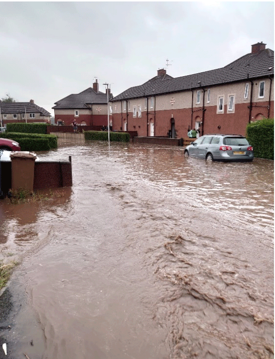
Image provided by Tillicoultry Flood Group
The developed partnership, working with key frontline agencies, secured public funding for demountable flood protection measures. A significant amount of work has taken place on agreeing how, when and where partners work together and focus efforts where they were most needed. Response planning was based on experience and trial and error, where the approach was refined after actual storm events.
Within a year, a walkway that separates homes from the river was raised by almost two metres and three years later, a pumping station was installed to help manage surface water.
In 2017 the Tillicoultry Flood Group became part of a network of flood groups along the Hillfoots area of Clackmannanshire, supported by the Council. The group worked in partnership with Scottish Fire and Rescue, Police Scotland, the Scottish Flood Forum, and others to produce a Flood Plan for the area that sets out how volunteers would work alongside other agencies to respond to flooding events. This plan was shared with the other Hillfoots groups to provide the basis of their response planning and adapted to suit local conditions.

Image provided by Tillicoultry Flood Group
The group meets with frontline partners after each flood event to debrief and identify potential improvements which could be employed during any future events. Furthermore, flood groups across the Hillfoots area (Menstrie, Alva, Tillicoultry, Dollar and Muckhart) meet monthly to discuss good practice, share experiences, and support one another.
Case Study 3: Kirkmahoe Community Council Resilience Plan - Working with communities to respond to flooding
Kirkmahoe Community Council set up a system to deal with emergencies, including flooding. The area of Kirkmahoe has been divided into 8 neighbourhoods with co-ordinators contacting volunteers when required to assist during emergencies. River levels are monitored by the group and warnings are posted via social media. Dumfries and Galloway Council are also informed of flooding by the Community Council and as a precaution activate remote flood warning signs at Carnsalloch and at Lakeview to warn drivers of road closures due to floods.
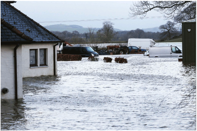
Image provided by Dumfries and Galloway Council
On 30th December 2022, towns and villages along the River Nith Cathment, including Kirkmahoe, experienced the worst flooding to date recorded. Flooding at Kirkton cut the area off from the rest of Dumfries and Galloway. From the time the Nith broke its banks upstream at Dalswinton and started flooding Kirkton, residents at Barrasgate had approximately 15 minutes warning to reach safety. 19 houses in Kirkton were badly damaged by the floods and many other premises had gardens and outbuildings destroyed by the flood.
The residents of Kirkton worked tirelessly to ensure the safety of their neighbours. Local tractor drivers assisted in transporting people from their flooded homes to the village hall. Following the event the Community Council, with support from the local authority, arranged for skips and liaised with the Roads Department to assist in getting roads reopened.
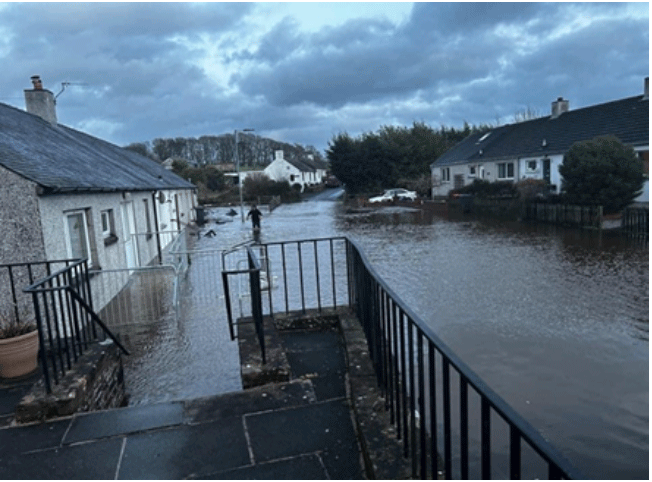
Image provided by Dumfries and Galloway Council
The Council provided industrial dehumidifiers to assist with drying homes. Funding was sourced for the worse affected residents, with a small cash donation for immediate needs. Due to delays in insurance payments, it took several months to get houses in a habitable state. In the meantime, residents were offered support by the Scottish Flood Forum. Some social housing in Barrasgate is still uninhabitable and there is ongoing discussion on future plans for these houses.
The Council, along with partners ran an event to discuss future flood resilience. This led to the formation of a community resilience group, which was tasked with identifying actions to make their community more resilient to flooding. A WhatsApp group was set up to improve the response time and communication. Funding was awarded to provide equipment to support the community during an event. Practical items such as heaters and cookers are also made available to all residents.
Case Study 4: Monitoring Moray’s Coastline – Collecting evidence through community volunteers
Public participation in scientific research is being promoted through the creation a network of photographic monitoring points along the Moray coastline. These points will allow the community to upload photographs of coastal change from the same viewpoint and upload them to the CoastalSnap App. This information will be used to inform Moray Council's Coastal Adaptation Plans and monitor change.
Communities are being encouraged to engage in the Monitoring Moray’s Coastline project and improve their own knowledge and understanding of how storm events are impacting on the coastline. It is anticipated the project will help raise awareness through public participation in data collection and monitoring.
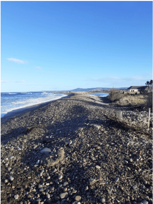
Image provided by Moray Council
The project will allow active monitoring of the indicative rate of change of the coastline, based on recording information from the same point. Using photographs will assist in predicting of the rate of change at a given point along the coastline.
Further details can be found at the Dynamic Coast website.
Case Study 5: Queensland Court and Gardens - Delivering multiple benefits for communities
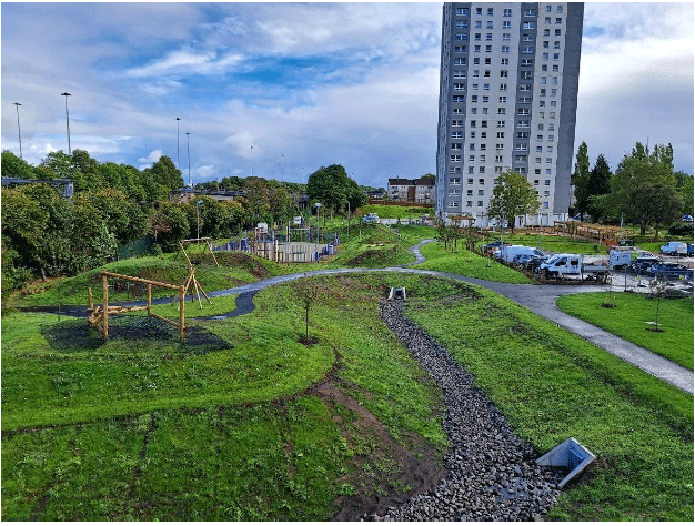
Image provided by Glasgow City Council
An area of underused greenspace in Cardonald, Glasgow has been transformed into a vibrant community park. The project has delivered an accessible, open space for residents - enhanced through an award-winning landscape design complemented by sustainable drainage measures that reduce flood risk. The project was a partnership between Southside Housing Association and Glasgow City Council. Other funders of the £2.6 million project include the Cardonald Area Partnership (through Glasgow City Council), the Scottish Government, the Place Fund (from the Scottish Government’s Regeneration Unit), Green Action Trust, EB Scotland, FCC Environment, Garfield Weston Foundation, The National Lottery Community Fund, Cycling Scotland, and the Clothworkers Foundation.
The attractive new space also boasts dedicated toddler and children's play spaces with climbing frames and slides, as well as a bicycle pump track and cycle storage facilities to encourage active travel. Sustainable drainage measures that mimic nature by slowing down water such as raingardens, basins, and swales, have also been introduced on site to reduce flood risk and increase downstream drainage capacity to support regeneration.
Extensive community engagement has meant that an enhanced open space has been created, which is suited to the community’s needs. Access to good quality green space was identified as being of vital importance for those living in the high-rise accommodation. A survey of residents, carried out by Research Resource on behalf of Southside Housing Association, found that 90% of those surveyed now say their neighbourhood is either a ‘very good’ or ‘good place to live’ - up from 68% before the park was constructed. The project has also delivered health benefits. Compared to a baseline survey from 2020, respondents use of greenspace at Queensland Court and Gardens has increased from 35% to 64% - with 30% now saying they go outdoors in their local area for fresh air 4-7 times a week, compared with only 10% previously.
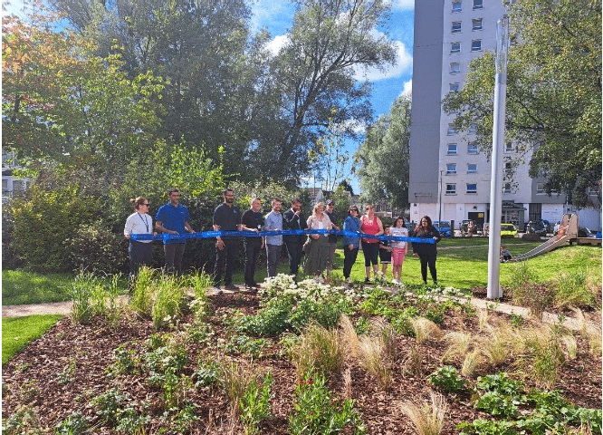
Image provided by Glasgow City Council
Further details can be found at the Glasgow City Council website.
Contact
Email: Flooding_Mailbox@gov.scot
There is a problem
Thanks for your feedback