Building standard 3.3 - flooding and groundwater guidance review: research
Research to inform the review of guidance which supports Standard 3.3, including identifying current good practice on flooding and groundwater and suggesting improvements and adoption of a good practice guide for local authorities.
3. Literature review
Introduction
3.1 The purpose of the literature review was to:
3.1.1 Identify the most relevant industry guidance and advice relating to building and development level flood risk assessment and the mitigation of the identified risk, including property flood resilience and groundwater protection of dwellings.
3.1.2 Analyse the literature around themes aligned with the main project objectives, specifically grouped around: frameworks for successfully ‘managing’ the risk assessment and mitigation of flood risk; examples of common practice and where local authorities differ in approach, noting any differences specific to either groundwater or flooding and analysing them separately.
3.1.3 A critique of the literature: commentary on the efficiency and differences in approach and offer practical recommendations for a standard, good practice approach to be applied by local authorities in requiring assessment and mitigation of flood risk where new development work is proposed.
Summary of literature review findings (main literature review follows this summary)
3.2 The Scottish building standards exist to ensure that design and construction details comply with the requirements of The Building (Scotland) Regulations (2004). Since building standards deal with design and construction details, i.e. property level measures, their focus will be on matters flowing from or supplementing flood avoidance strategies. Once decisions around flood avoidance have been agreed, building standards officers then move the focus to property level measures at individual sites. A thematic analysis of the literature shows that these measures consist of the options shown in Table 3-1, the selection of which will depend on the local conditions and flood risk strategy.
| Property Level Measures (strategy) | Comments on strategy |
|---|---|
| Avoid: Elevate the building on land | Achieves preferred option of raised floor levels; but may cause flooding elsewhere. |
| Avoid: Elevate the building (up to 2m) | Achieves preferred option of raised floor levels; but only if sub-floor can be accessed for maintenance. |
| Avoid: Elevate the building (over 2m) | Achieves preferred option of raised floor levels (if planning constraints allow it); consider access/egress to habitable areas. |
| Exclude water entry: Use of perimeter protection | Relevant for critical infrastructure but may cause flooding elsewhere. |
| Exclude water entry: Make it flood resistant | Suitable up to 600mm flooding but may cause flooding elsewhere. |
| Allow water entry: Make it flood recoverable | Suitable for flooding over 600mm, long-duration flooding, and groundwater flooding. |
| Reduce exposure: Make the building movable/temporary | Suits temporary build, deconstruction/ de-anchoring for relocation, but may be susceptible to displacement in sudden high velocity flood. |
| Reduce exposure: Design building to be transitional | Allows temporary changes via planning policy: - e.g. limited time of occupation; planned change from habitable to non-habitable. |
| Reduce exposure: Amphibious building | Flexible design: buoyant building rises on guideposts, best located in dry dock; for flooding 1m - 1.5m. |
| Reduce exposure: Design building to float | Flexible design: like a houseboat, located in water; but not suitable for rapidly changing or fast-flowing water. |
| Reduce exposure: Self- elevating (jack-up) building/barge | Flexible design; hybrid of amphibious/floating building; suitable in water up to 6m deep. |
3.3 The measures shown in Table 3-1 are defined as property flood resilience (PFR), as described in CIRIA publication ‘Code of practice for property flood resilience’ C790 (2nd Edition) (CIRIA, 2019). This CIRIA definition includes the measures that prevent water entry as 'resistance'; and those that limit the damage of water entering property as 'recoverability' measures. This guidance has recently become a key reference suite (of four guides) for PFR, and should be used to help apply an integrated approach to flood risk management as shown in Table 3-2.
CIRIA C790 Standard |
Building Standards process |
|---|---|
Stage 1 Hazard Assessment |
Building Warrant: Flooding type(s), depth, speed, duration and frequency. Property survey (existing) and design review (new build); specified materials/building elements, and any proposed PFR solution. |
Stage 2 Property Survey (existing buildings) |
|
Stage 3 Options development and design |
|
Stage 4 Construction |
Completion Certificate: On-site checks/inspections to verify specified PFR solutions have been achieved (CCNP*). Evidence of in-situ and wet testing. Optional confirmation of: Post installation audit (PiA); Homeowner Flood Plan (or O&M manuals). |
Stage 5 Commissioning and handover |
|
Stage 6 Operation and maintenance |
*This could be added to the Construction, Compliance and Notification Plan
3.4 The literature review, including analysis of guidance provided by three Local Authorities, has identified potential links between activities during Planning Application and the work of building standards officers. These are summarised in Table 3-3 and should form the basis for driving a more integrated approach to flood risk management within Local Authorities. Note that this is not an exhaustive list.
Issues identified at Planning Application |
Relevance to Building Standard 3.3 |
|---|---|
Flooding, general |
Recommendations of FRA for property level measures. |
Drainage, general |
Recommendations of DIA for property level measures. |
FRA Results/Conclusions/Checklist |
Appropriate design to suit flood risk; sensitivity analysis; quantity of flood compensation required; expected flood levels; appropriate freeboard; access/egress; residual risk measures (e.g. PFR); maintenance requirements. |
DIA pre-application meeting (H: only larger/sensitive developments) |
Possible trigger point to advise building standards officer of surface water risk. |
Drainage statement (under 5 dwellings/ under 100 m²) |
Site topography; drainage arrangements; permeable/ impermeable surfaces. |
DIA requirements |
Historic drainage patterns; topography; soil characteristics; permeable/ impermeable surfaces; SUDS; sewar connections/ arrangements; impacts on/off-site; measures during construction stage. |
Drainage Master Plan |
Link between property-level measures and wider strategies. |
Design exceedance |
Surface water risks. |
Opportunity to inspect drainage features |
Copy evidence to building standards officer. |
Riparian Buffer Strips |
Applies to properties close to water. |
Detailed SUDS guidance |
Risks to public; nature-based solutions; root protection barriers; liners, raingardens; living roof; swales; and permeable surfacing. |
High velocity flooding |
Appropriate erosion protection, especially around raised land, perimeter walls, building external walls. |
High water table |
Infiltration measures via SUDS may not be possible. |
Development of floodplain corridor |
No ground raising in floodplain corridor, avoid building obstructions (e.g. fences, hedges, outbuildings etc.) |
Allowance for freeboard |
Threshold levels for building design. |
3.5 New-build property-specific strategies will depend on building types, which will have their own unique strengths and weakness. These fall into the broad categories of: Detached; Semi-detached; Terraced; Flat; and Bungalow. Bungalows are not recommended in areas at risk of flooding. PFR strategies will mainly depend on the recommendations of an FRA. In general terms, good practice should dictate the following strategies:
- Mainly water exclusion strategy (dry-proof)
- Flooding up to 0.3m
- Flooding from seawater
- Flooding from overloaded sewer systems
- Short duration flooding
- Both exclusion/entry (subject to structural assessment)
- Flooding 0.3m-0.6m
- Groundwater flooding up to 0.6m
- Long duration flooding up to 0.6m
- Mainly water entry strategy (wet-proof)
- Flooding over 0.6m
- Groundwater flooding over 0.6m
- Long duration flooding over 0.6m
3.6 New-build water exclusion good practice should focus on the following building elements, which can be used to create checklists for risk evaluation:
- Ground-supported floors
- Suspended floors
- Exposed metalwork
- Hardcore and blinding
- Damp-proof membranes
- Insulation materials
- Masonry walls
- Framed walls
- Reinforced concrete walls
- External renders
- Internal linings
3.7 Reports by suitably qualified professionals should address technical solutions for each of these building elements, in line with specific reference to BS 8533:2017; BS85500:2015 (Draft BS85500:2024 contains a more comprehensive list of design details); and BS EN ISO 16535:2019. New-build resilience good practice should be considered for the following, in line with the guidance of Barsley (2019):
- electrical systems
- plumbing
- fixtures and fittings
- kitchen
- garage
- office
- Good practice for existing buildings should be considered for the following, in line with the guidance of BS 8533:2017; Barsley (2019); and BRE GG84 (BRE, 2014):
- Solid floors
- Block/Beam floors
- Suspended floors
- Flood doors
- Roller-door/Ground-up/Top-down/Hinged barriers
- Flood window
- Flood skirt
- Utility box covers
- External tanking
- Air brick covers
- Non-return valves
- Service entry points
- Weep holes
- Bungs
- Sump and pump systems
3.8 Groundwater good practice should follow guidance for the control of hydrostatic impact of rising groundwater on ground floors and basements (BS 8533:2017). The Sustainable Urban Drainage Scottish Working Party (SUDSWP) publication: Water Assessment and Drainage Assessment Guide: A guidance document for developers, planners and others involved in water and drainage (2016) provides good practice guidance in addition to those measures already discussed as part of DIA requirements (CIRIA C753). The SUDSWP guide for water assessment and drainage assessment provides a useful checklist for Building Warrant that is recommended for building standards officers:
- Site location plan
- Drainage layout proposal
- Construction detail drawings
- Longitudinal section drawings
- Calculations
- Manhole schedules
- Soil investigations (if applicable)
- Mechanical and electrical (if applicable)
- SuDS risk assessment
- Risk assessment and method statement
3.9 Relevant literature from other sources includes alternative analytical process for choosing construction methods and evidence for preferential use of PFR. However, these need further research and evidence before recommending adoption. Guidance and good practice from mainland Europe and USA merit further investigation to enhance Scottish building standards processes.
Background
3.10 Flooding and groundwater issues pose significant challenges in Scotland, necessitating effective flood risk assessment, with strategies to avoid flooding, and mitigation measures, including property level protection such as PFR. This literature review aims to explore guidance and standards, relevant studies, research papers, and reports that discuss the topics of flood risk assessment, property level protection for flooding and groundwater in Scotland, to inform good practice that can be used by verifiers when assessing building warrant applications against building standard 3.3 - Flooding and groundwater.
3.11 Flooding can occur due to various factors, including heavy rainfall, river overflow, or coastal surges. Groundwater, on the other hand, refers to the water present beneath the ground surface, which can rise to cause flooding in certain circumstances. The Scottish Environment Protection Agency (SEPA) has emphasized the need for appropriate flood risk management strategies, including property level protection, to safeguard vulnerable areas (SEPA, 2020). The impact of flood water on a building depends on the nature of the flooding and the design and construction of the property. Examples of impacts are described in BS 85500:2015; Table 1 (BSI, 2017).
Regulatory Framework
3.12 The Town and Country Planning (Scotland) Act 1997 is the principal piece of legislation governing the use and development of land within Scotland. This Act requires that functions relating to the preparation of the National Planning Framework by Scottish Ministers and development plans by planning authorities must be exercised with the objective of contributing to sustainable development. The Flood Risk Management (Scotland) Act 2009 implements for Scotland provisions of Directive 2007/60/EC of the European Parliament and of the Council on the assessment and management of flood risks. The purpose of the Directive is to establish a framework for the assessment and management of flood risks, aiming at the reduction of the adverse consequences for human health, the environment, cultural heritage and economic activity associated with floods. The Act makes provision in relation to: (a) coordination and cooperation within the domain of flood risk management; (c) assessment of flood risk and preparation of flood risk maps and flood risk management plans, including implementing the Directive; (c) functions of local authority and Scottish Environment Protection Agency for flood risk management; (d) a revised statutory process for flood protection schemes; and (e) the enforcement regime for the safe operation of reservoirs.
3.13 In Scotland, NPF4 sets out the spatial principles, regional priorities, national developments and national planning policy. Policy 22 of the framework covers ‘Flood risk and water management’ (Scottish Government, 2023). The Policy’s intent is to strengthen resilience to flood risk by promoting avoidance as a first principle and reducing the vulnerability of existing and future development to flooding. This can include a wider use of natural flood risk management to benefit people and nature.
3.14 The Building (Scotland) Regulations 2004 set out mandatory functional standards applicable to the design and construction of buildings to ensure they are safe, energy efficient and sustainable. the Scottish Government publishes guidance in support of the standards within domestic and non-domestic Technical Handbooks which, if followed in full, is accepted as demonstrating compliance with the standards. The regulations, standards and supporting guidance in the Technical Handbooks apply based upon the date on which a building warrant application is submitted or when work not requiring a building warrant is commenced.
3.15 Guidance to Standard 3.3 - Flooding and groundwater states that where there is a risk that flooding can affect a building, it is important that any proposed construction is designed to be more resistant and resilient. Where development is to take place on land assessed by the planning authority as having a flood risk, advice should be sought from sources such as the local planning authority, SEPA and others.
3.16 To reduce the risk to buildings from groundwater, subsoil drainage of a site may be necessary to protect against penetration of groundwater through a building and damage to the building fabric. Conversions shall meet the requirements of the standard in so far as is reasonably practicable, and in no case be worse than before the conversion. Ground below and immediately adjoining a building that is liable to accumulate groundwater, at a level that could affect the structure or penetrate the building, requires subsoil drainage or other dewatering treatment to be provided to mitigate against the harmful effects of such water. Field drains, where provided, should be laid in accordance with the recommendations in clause 10 of BS 8301: 1985. In managing surface water run-off to adjacent sites, the formation of channels or small dams to divert the run-off or, where conditions are particularly serious, the installation of field drains or rubble drains may overcome the problem.
3.17 Guidance to standard 3.3 states that development flood risk assessments should be an integral part of the design and construction process with the appraisal also considering the effects that the development may have on adjoining ground. Guidance to standard 3.3. cites Planning and Building Standards Advice on Flooding (PAN 69), and for site specific flood risk assessments the CIRIA document ‘Development and Flood Risk – guidance for the construction industry’ (C624) 2004 is signposted for detailed guidance on carrying out flood risk assessment and suggests design considerations for developers.
Technical Guidance and Standards
3.18 The Planning and Building Standards Advice on Flooding (PAN 69) (Scottish Government, 2004) is now withdrawn and superseded by the Scottish Government publication ‘Flood Risk’ (Scottish Government, 2015), although PAN 69 is still cited in the technical handbooks, including the drafts that are proposed for 1st April 2024 and has informed this literature review.
3.19 Construction Industry Research and Information Association (CIRIA) ‘Development and Flood Risk – guidance for the construction industry’ (C624) (CIRIA, 2004) provides detailed guidance on carrying out flood risk assessment and suggests design considerations for developers. These include potential property-level measures, including: raising floor levels; land raising; flood proofing; and dealing with run-off. CIRIA publication ‘Code of practice for property flood resilience’ C790 (2nd Edition) (CIRIA, 2019) has more recently become a key reference suite of four guides for property flood resilience (PFR), defining six Standards to follow:
- PFR Standard 1: hazard assessment
- PFR Standard 2: property survey
- PFR Standard 3: options development and design
- PFR Standard 4: construction
- PFR Standard 5: commissioning and handover
- PFR Standard 6: operation and maintenance
3.20 Since building standards in Scotland are focused on the design and specification of buildings, once flood avoidance strategies are applied via the planning process, at the Building Warrant application stage, PFR measures represent the key remaining strategy for achieving effective property level flood damage mitigation. PFR guidance can be applicable to both Domestic (residential) and Non-Domestic (Commercial) properties at risk of flooding. PFR can be applied to extensions, change of use and retrofitting. It can also be applied to new build with some caveats e.g. temporary demountable measures are not recommended for new build. The CIRIA CoP 790 Standards are summarised in Table 3-4 through to Table 3-9.
Table 3-4 PFR Standard 1: hazard assessment
Aim
Deliver a property level flood risk assessment, which clearly summarises the available hazard information to determine the likelihood and severity of flooding from different sources. This information will be used to inform the selection and design of PFR measures.
Requirements
1. A survey of the flood risk to the property shall be carried out. The scale and detail of the survey shall be proportionate to the perceived level of risk and the potential size of the project. Surveys shall be extended should a greater complexity of flood risk become apparent during the survey.
2. The site of the property shall be assessed for the likelihood of flooding based on a ‘source–pathway–receptor’ approach for all potential sources and range of probabilities of flooding.
3. The potential source(s) of flooding shall be determined using appropriate methods of hazard identification. This shall be accompanied by an assessment of flood frequency, as well as depth and duration for all sources at a range of return periods.
4. The property flood risk assessment shall take account of relevant flood risk information from local authorities, utilities and other environment agencies. It shall take account of additional flood risk information from other relevant sources (including property owners).
5. The potential routes of floodwater (pathways) to the buildings/structures within the property from the sources shall be identified.
6. The pathways for flooding from each source to the property and likely speed of onset shall be identified, including measures that currently exist, or are planned, for controlling that pathway at the property, community or catchment scale (including flood defence works). This analysis shall include all relevant structures near to the property.
Table 3-5 PFR Standard 2: property survey
Requirements
1. The scale and detail of the survey shall be proportionate to the level of risk and the size of the project. The survey shall also identify appropriate approaches to increase resilience and minimise damage, with reference to the end user needs.
2. The survey shall establish the building type, age, construction, condition, operation and contents.
3. The current level of PFR shall be established, including estimating the water leakage resistance capacity of the walls and floors, the recoverability of the materials and components, and end user capacity to implement measures.
4. The method of drying and decontamination of the building after a flood shall be assessed, including the impact of wetting of building materials and that of voids and cavities in walls and floors.
5. The ground conditions on the site shall be established, and in particular, the potential for water to transfer through the ground or from an adjacent building into the building shall be assessed.
Table 3-6 PFR Standard 3: options development and design
Aim
Allows options for PFR to be identified and considered. These options shall reflect the outcomes from Standards 1 and 2, and PFR measures suitable for the property and specify the most suitable PFR measures for the property. The options for PFR will consider the use of:
a) measures that restrict water entry to the building under defined conditions
b) materials that are recoverable after water contact
c) services, fixtures and fittings that are recoverable by their location and/or ability to resist water damage.
The design and specification will be based on the information provided by Standard 1 and 2, and the measures specified shall be selected impartially.
Requirements
1. An options appraisal of flood resilience measures shall be undertaken based on the information generated within Standards 1 and 2. These appraisals shall also evaluate costs and benefits of suitable approaches, end user needs, operation and performance.
2. The appraisal shall evaluate the lifetime maintenance and operation requirements of the measures considered.
3. Where possible, and where relevant, specified PFR measures shall make use of products and processes that are compliant with a recognised industry standard and/or are subject to a warranty.
4. The preferred options shall be agreed and documented.
5. This specification shall be set out in drawings and/or written text and shall adequately describe the measures to be taken and their method of installation.
6. The output is the identification and specification of the most suitable PFR measures for the property. This information shall then be developed into a construction/installation plan, undertaken by the appropriate person before any works or installation begins.

Table 3-7 PFR Standard 4: construction
Aim
Ensures that the construction works deliver the specified PFR measures to the required standard and with the desired outcomes.
Requirements
1. The appropriate person shall deliver all the necessary works associated with the construction and installation of PFR measures.
2. Where subcontractors are used, the appropriate person shall retain overall responsibility for the works.
3. All necessary preliminary work, including drying out and decontamination where appropriate, shall be carried out prior to implementation of PFR measures. These works shall be carried out in accordance with the design and specification described in PFR Standard 3, and shall take due note of the flood risk assessment (PFR Standard 1) and the survey (PFR Standard 2).
4. The construction work shall be undertaken in accordance with good practice, including relevant standards, guidance and legislation, and shall comply with CDM 2015.
5. All PFR measures shall be inspected during construction by an appropriate person.
Table 3-8 PFR Standard 5: commissioning and handover
Aim
Ensures that the completed PFR construction work will operate effectively as designed, and that the end user has all relevant information and has been instructed in any deployment, operation and maintenance requirements.
Requirements
1. PFR measures shall be inspected during construction (PFR Standard 4) and on completion by an appropriate person to ensure that the work meets the design and specification requirements of PFR Standard 3. The inspection shall be conducted in an objective and impartial manner.
2. Any products used which have an agreed in situ flood resistant test procedure shall be tested after their installation within the building(s) at the request of the end user. These tests shall be supervised by an appropriate person.
3. The appropriate person shall provide all relevant information on the PFR works, design, specification, and operation and maintenance requirements in a project file (ie a handover pack) to the end user.
4. Where PFR measures need to be deployed for flood events, a person shall be nominated and agreed to take responsibility for deploying the measures in the event of a flood warning. This person shall be referred to as the ‘nominated person’.
5. The appropriate person shall demonstrate the method of deployment of measures (where appropriate) to the nominated person and shall ensure that this person understands how to prepare for a flood.
Table 3-9 PFR Standard 6: operation and maintenance
Aim
Ensures that the completed PFR construction works are properly operated and maintained, and that any demountable equipment is stored correctly. Note that the responsibilities and duties for operation and maintenance are defined as part of meeting the requirements of Standard 5.
Requirements
1. The appropriate person, in accordance with CDM 2015, shall provide an operation and maintenance plan to the end user at the point of handover.
2. The nominated person shall ensure that the PFR measures remain operative by following the guidance provided in the handover pack.
3. In the event of a flood warning, the nominated person shall deploy any measures following guidance provided in the handover pack.
4. Any operation of the PFR measures shall be recorded and the information retained and kept securely as an appendage to the handover pack.
5. All maintenance work shall be recorded and kept securely as an appendage to the handover pack.
6. The PFR measures shall be reviewed periodically to ensure that they continue to meet the needs of the end user and that the nominated person can continue with their obligations.
7. After a flood event, the PFR measures shall be fully checked and inspected by an appropriate person taking account of the information in the handover pack. Any necessary maintenance shall be commissioned and delivered by an appropriate person.
Integrated approach to building standards: planning application
3.21 A critical aspect of the planning application process, in relation to flood risk, is the completion of a flood risk assessment, which should be carried out in accordance with NPF4, Online Planning Advice on Flood Risk, SEPA’s Technical Flood Risk Guidance for Stakeholders and any local planning policy requirements. It is necessary to show that, if it is not possible to avoid the flood risk, then adequate protection against flooding exists or can be provided for the proposed development and that the new development does not increase any existing flood risk to persons or property upstream or downstream. Planning regulations throughout the UK require that PFR should be included where permission is given to build in a flood risk area (CIRIA, 2020).
3.22 NPF4 stipulates that Local Development Plans (LDP) should strengthen community resilience to the current and future impacts of climate change, by avoiding development in areas at flood risk as a first principle. Resilience should also be supported by managing the need to bring previously used sites in built up areas into positive use; planning for adaptation measures; and identifying opportunities to implement improvements to the water environment through natural flood risk management and blue-green infrastructure. For areas where climate change is likely to result in increased flood exposure that becomes unmanageable, consideration should be given to alternative sustainable land use.
3.23 The protection offered by an existing formal flood protection scheme or one under construction can be taken into account when determining flood risk. In such cases, it will be demonstrated by planning applicants that:
- all risks of flooding are understood and addressed;
- there is no reduction in floodplain capacity, increased risk for others, or a need for future flood protection schemes;
- the development remains safe and operational during floods;
- flood resistant and resilient materials and construction methods are used; and
- future adaptations can be made to accommodate the effects of climate change.
- Additionally, for development proposals meeting criteria (part iv), where flood risk is managed at the site rather than avoided these will also require:
- the first occupied/utilised floor, and the underside of the development if relevant, to be above the flood risk level and have an additional allowance for freeboard (specialist task calculated as part of FRA (Scottish Government, 2004)); and
- that the proposal does not create an island of development and that safe access/ egress can be achieved.
3.24 Small scale extensions and alterations to existing buildings (including material change of use) will only be supported where they will not significantly increase flood risk[3]. In addition, development proposals will:
- not increase the risk of surface water flooding to others, or itself be at risk;
- manage all rain and surface water through sustainable urban drainage systems (SUDS), which should form part of and integrate with proposed and existing blue-green infrastructure. All proposals should presume no surface water connection to the combined sewer; and
- seek to minimise the area of impermeable surface.
3.25 The production of flood risk assessments will make use of public data sources, such as flood risk maps, produced in Scotland by the Scottish Environment Protection Agency (SEPA) and historical flooding records, as well as possibly reports from Scottish Water and other sources, often involving flood modelling of the site.
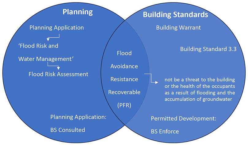
3.26 When the FRA recommends managing flood risk at the site, Building Standard 3.3 should become relevant, with PFR measures being a likely recommendation. However, CIRIA guidance (C790D) 'Code of practice for property flood resilience: guidance for local authority planners' states that PFR should be driven through the planning application process and not by building control inspectors (in England). The same guidance also acknowledges that there are a few opportunities through the building regulations to influence the use of PFR, which in the Scottish context, BS 3.3. could be considered one such example of this. Therefore, it seems appropriate for Scottish planning authorities to retain control over PFR flowing from FRA recommendations as part of planning approval, in liaison with building standards personnel who should respond to confirm BS 3.3 is being met.
3.27 Key parameters of flood risk assessment are the expected flood depth, duration and frequency. For developments where flood risk needs to be managed at the site, this will determine the likelihood of being able to keep water out of the building (resistance), or whether it is more cost-effective to plan for water ingress (resilience).
3.28 Predicted flood water levels will dictate designed thresholds for buildings. It is also recommended that the most vulnerable properties in a development be sited in areas with the lowest flood risk; they be designed to be put back into use quickly after a flood; incorporates sustainable drainage systems; any residual risk can be safely managed; and safe access and emergency escape routes are included.
3.29 Other planning implications for PFR include issues such as whether the existing or proposed property is in a conservation zone, or a listed building. There may be restrictions on e.g. ridge-heights, materials, or certain visible PFR items (e.g. door brackets). Further information is provided on flooding and historic buildings in Chapter 26 of C790B and also from Historic Environment Scotland.
3.30 Whilst not yet approved at the time of writing, the Draft BS 85500:2024 (BSI, 2024) makes extensive reference to the CIRIA Code of Practice 790 as a recommended standard to follow for improving flood performance of buildings. While the CIRIA CoP 790 is primarily for retrofitting PFR, like all flood resilience measures it is much easier for PFR to be incorporated into a development if it is considered early in the design and specification process and in an integrated way with other design considerations. Incorporating PFR at the design stage of an appropriate new building or development is far simpler than retrofitting an existing building or adding it to the design of a new building late in the process. The alignment of the CIRIA CoP 790 Standards with the planning application process is described in CIRIA Report C790D (CIRIA, 2020).
Integrated approach to building standards: building standards
3.31 For most construction work, as part of permission to construct, and aside from road construction, a building warrant is required which is separate from planning permission and is related to technical detail of construction or installation. An application for building warrant requires to be made and the building warrant granted before work commences on site. The building standards surveyors within the local authority review proposals to ensure that design and construction details comply with the required standards.
3.32 As building standards deal with design and construction details, i.e. property level measures, their focus will be on matters flowing from or supplementing flood avoidance strategies. CIRIA guidance (C790D) 'Code of practice for property flood resilience: guidance for local authority planners' states that there are no requirements under building regulations to install PFR measures. However, as stated earlier in Scotland (under BS 3.3) there is an explicit requirement for building work to be designed and constructed so that there is no threat to the building itself or to the occupants as a result of flooding. Local authorities can also provide clarity and certainty for developers by making additional recommendations for appropriate developments as part of local planning policies, supplementary planning documents, masterplans, local design codes or guidance and evidence (e.g. in a Strategic Flood Risk Assessment). This could include setting out the local authority’s preferred strategy for flood risk mitigation and PFR in relation to urban design, building design, risk management, and how flood mitigation measures can be integrated into the development design. When considering property level PFR measures, these should not increase the flood risk elsewhere and should ideally reduce the overall flood risk.
3.33 Whilst CIRIA Report C790D provides guidance on alignment of the C790 Standards with planning applications (CIRIA, 2020), it can also be aligned with building standards processes if Scottish Local Authorities find this beneficial in aligning planning conditions relating to flood prevention and management with BS 3.3. Table 3-10 illustrates how CIRIA C790 can be aligned with the Building Warrant and Completion Certificate requirements. It is also important to highlight that Standard 3 of the CIRIA C790 Code of Practice is split into two parts: outline design/optioneering, and then detailed design and specification. Each of these parts may require different types of expertise.
CIRIA C790 Standard |
Building Standards process |
Relevant Reference |
|---|---|---|
Stage 1 Hazard Assessment |
Building Warrant: Flooding type(s), depth, speed, duration and frequency. Property survey (existing) and design review (new build); specified materials/building elements, and proposed PFR solution. |
C790B: Chapter 12 |
Stage 2 Property Survey (existing buildings) |
C790B: Chapter 13 Draft BS85500 Clause 4.4 |
|
Stage 3 Options development and design |
C790B: Chapters 14, 23, 25 |
|
Stage 4 Construction |
Completion Certificate: On-site checks/inspections to verify specified PFR solutions have been achieved (CCNP*). Evidence of in-situ and wet testing. Optional confirmation of: Post installation audit (PiA); Homeowner Flood Plan (or O&M manuals). |
C790B: Chapter 15 |
Stage 5 Commissioning and handover |
C790B: Chapter 16 |
|
Stage 6 Operation and maintenance |
C790B: Chapters 17 & 24 |
*May be included in Construction Compliance and Notification Plan (CCNP)
3.34 Surveys of existing buildings and design reviews for new builds should assess their current level of flood resilience, in the context of the flood hazard assessment, and in accordance with CIRIA CoP C790 (CIRIA, 2019). These should be completed by suitably trained and qualified individuals. Consultation with specialists may be required to assist with assessing appropriate PFR solutions. The surveys and reviews should be detailed in proportion to the level and scale of flood risk predicted. This should document the materials and building elements susceptible to flood risk. The building survey (or design review) should identify the anticipated end users of the building, and determine their user-needs, including required resources to support the proposed PFR solution. The most important aspects of the survey/review are:
- Whether any installed PFR measures have been correctly designed, installed and appropriately maintained;
- That the installed PFR measures will be available for a flood event if they require someone to actively fit them. Such measures must take into account the availability, capacity and resources of those required to install them, and if there will be sufficient notification of the flood event. Where adequate warning cannot be given then passive measures must be utilised;
- The presence of flood recoverability (for existing buildings) and its suitability/effectiveness.
3.35 Checks should be made on site to verify that the approved design has been achieved in the construction work. This can include evidence of testing of equipment (e.g. sump/pump, property alarms, automated equipment) and in-situ wet testing of installed PFR building elements (e.g. tanking, covers, seals etc.) or structural members critical to the PFR solution. Building standards officers may decide to specify an inspection programme as part of the Construction Compliance and Notification Plan (CCNP) or allow alternative options. This may include photographs, inspection, test reports or certificates of construction issued by an Approved Certifier of Construction (Local Authority Building Standards Scotland, 2013).
Integrated approach to building standards: Local Authority Guidance
3.36 Each of Scotland’s 32 Local Authorities have to incorporate flood risk and water management into their Local Development Plans, and also have Local Flood Risk Management Plans (Scottish Government, 2015). In so doing, some Local Authorities have created guidance to assist with compliance with these requirements. Table 3-11 shows three Local Authorities’ guidance, which was available for analysis as part of the literature review.
Local Authority |
Title/Focus |
Year |
|---|---|---|
Glasgow City Council (G) |
Flood Risk Assessment and Drainage Impact Assessment: Planning Guidance for Developers |
2011 |
The Highland Council (H) |
Flood Risk & Drainage Impact |
2013 |
City of Edinburgh Council (E) |
Sustainable Rainwater Management Guidance (part of a suite) |
2021 |
3.37 The Local Authority guidance available for review was published over a 10 year timeframe, which is reflected in the documents cited within them. However, there are general similarities and some differences worth noting.
3.38 The guidance from Glasgow City Council is the oldest publication from the sample (GCC, 2011). Its focus is on risk assessment for flooding and drainage impact assessment and is mainly aimed at developers. According to the guidance, they operate a mandatory self-certification scheme for any residential development comprising more than 5 dwellings and for industrial or commercial developments of more than 250 m2 (for both FRA and DIA). Minimum requirements for the FRA Report are: Base Data Requirements; Methodology used in carrying out the assessment; Hydrological methods used in the assessment; Conclusions. Detailed tables of these requirements are in the Appendix of this report.
3.39 Glasgow requires a Drainage Impact Assessment (DIA) to be submitted with the first planning application requiring waste or surface water to be drained. They recommend a pre-application meeting takes place for larger schemes and when the development is in sensitive areas. There is also a recommendation that the developer should consult with Scottish Water on appropriate SUDS. Requirements of the DIA are in the Appendix of this report. Reference documents for surface water drainage include the Design Manuals for Scotland and Northern Ireland and the specification set out within Sewers for Scotland 2nd Edition. This must also conform to the basic level of treatment control outlined within the General Binding Rules of the Controlled Activities Regulations 2005 and be approved by SEPA and or Scottish Water.
3.40 Glasgow require that a drainage master plan covering the whole area of development be submitted. The only mention of building standards is a generic paragraph stating that designs must comply with the Building Standards (Scotland) Regulations of the time the guidance was published. Compliance Certificate requirements include £5m Professional Indemnity Insurance, and to be independently checked by a competent professional. A list of all requirements and checklists is provided in the Appendix to this report.
3.41 The guidance form The Highland Council (THC) covers their planning policy on flooding and development, focused on flood risk and DIA and how it should be put into detailed planning, construction, and maintenance (THC, 2013). Authorship was led by the THC Flood Team, in consultation with SEPA in 2013. The guide is laid out with sections covering roles and responsibilities; FRA; DIA; certification and checklists; Building Standards; SUDS; and riparian buffer strips. The roles and responsibilities are summarised under the headings of Developers; Scottish Government; SEPA; THC; Scottish Water; Northern Constabulary; Highlands & Islands Fire & Resue Service; Met Office; Transport Scotland; Scottish Flood Forum; Landowners; and Householders. A checklist of matters to consider is in the Appendix of this report.
3.42 THC will request an FRA if the Planning Authority considers there might be a risk of flooding to a proposed development. THC require all new development to be free from unacceptable flood risk for all flood events up to the 1 in 200 year return period (including an allowance for climate change), and 1 in 1000 year return period for potentially vulnerable developments such as care homes, schools, critical infrastructure etc. FRA reference guidance is mainly CIRIA C624, with direct reference to the Levels of flood risk assessment: (1) Screening study; (2) Scoping study; (3) Detailed study. The content of the FRA is listed as: Background information; Methodologies; Results; and Conclusions. A full list of items is in the Appendix to this report.
3.43 DIA is acknowledged to be proportionate, with a ‘Drainage Statement’ for small developments and full DIA for lager developments. Drainage statements are only required for: householder applications; four or less dwellings (and not in a sensitive area); extensions under 100 m²; changes of use not involving new buildings or additional hardstanding; or for part addition to a previously submitted DIA. A pre-application meeting needs to take place for larger schemes and those located in sensitive areas. This may involve THC Planning & Development, THCs Technical, Environmental and Community Services, SEPA and Scottish Water. Requirements for Drainage Statement and DIA are in the Appendix of this report. Surface water references include CIRIA Publication C697 - The SUDS Manual, and General Binding Rules of CAR 2011. Design exceedance is covered, including the requirement for a sensitivity test for 1 in 200 year event, and there is mention of road drainage and foul water. Approvals are required for DIA from Scottish Water (connection) THC (adoption of road) and SEPA (CAR 2011 authorisation). Certification of Level 1 FRA and Drainage Statements can be completed by the applicant. Level 2 and 3 FRA/DIA must be completed by a competent professional. Professional Indemnity /insurance is set at £1m.
3.44 A generic paragraph mentions Building Standards, stating that designs must comply with the Building Standards (Scotland) Regulations of the time the guidance was published. In addition, THC should be given the opportunity to inspect drainage features, with as-built drawings submitted to the THC Flood Team. THC seeks a minimum buffer strip of 6 metres between the top of the bank of any body of water within an application site and any proposed new development. buffer strips may be secured by a planning condition.
3.45 The City of Edinburgh Council provided the most up to date guidance (2021) on sustainable rainwater management (City of Edinburgh Council, 2021). This is in fact a suite of seven documents, consisting of a main guide (70 pages), and six further supplements: Surface Water Management Checklist; Trees Factsheet; Swales Factsheet; Rain garden Factsheet; Water Management Plan; and Flood Risk And Surface Water Management Plan Requirements. The guidance was developed by Atkins, with support from University of Abertay and SUSTRANS. The guide includes a great deal of context and links to other matters with a main section on design principles, which is aimed at planners, designers and developers.
3.46 Included in the background and context information is data on the geology and topography of Edinburgh, as well as main soil types for the area. A flow-chart illustrates the process of applying the design principles for master-planning a new development. SUDS components of the design principles are listed in relation to street types. The list is reproduced in the Appendix to this report. Three scales of development are covered by the design principles: Basic; Standard; and Innovative. These dictate the range of SUDS to be used. Special design considerations apply to World Heritage Sites, conservation areas and listed structures or buildings in Edinburgh, in which case the visible components of SUDs need to be carefully considered. The guide references CIRIA’s SUDS Manual C753 (2015).
3.47 Risk to the public is coved in the Edinburgh guidance: fences round SUDS features should be proportionate, but are required if a person can fall more than 2m. ‘Earth benches’ (narrow level terraces) of 1m minimum width should be provided at water features, both wet (within the water feature) and dry (above). A full list of Do’s and Don’ts is shown in the Appendix to this report. Designing with nature guidance lists more Do’s and Don’ts is also shown in the Appendix. Rainwater harvesting is described as good practice, with reference to BS EN 16941-1:2018, which includes separation form mains supply. Other good practice examples include root protection barriers (to separate roots from services), liners, raingardens, living roof, swales, and permeable surfacing. Underground tanks are seen by Edinburgh as a last resort, due to backing up, lack of natural water treatment and difficult maintenance.
3.48 The Edinburgh guide lists the steps for design considerations for SUDS as:
- Assemble the team; Contact Scottish Water;
- Look at flow patterns and hydrology;
- Look at ecology and natural assets;
- Look at heritage and landscape character;
- Prepare an Environmental Constraints Plan;
- Contact City of Edinburgh Planning Department;
- Look at Edinburgh Planning Guidance;
- Prepare the Surface Water Management Plan (SWMP).
- This should:
- Include source control;
- Design for exceedance;
- Consider beauty and amenity;
- Consider maintenance, health and safety;
- Consider Standards and adoptability;
- Use Edinburgh Design Guidance Factsheets;
- Use Appropriate Planting and Maximise Biodiversity;
- Provide interpretation.
3.49 A summary of the benefits of SUDS options are shown in the Appendix to this report.
3.50 These three pieces of guidance, received from Local Authorities, appear to have significant alignment with the requirements of Scottish Government surface water management planning (SWMP) guidance (Scottish Government, 2018), which in turn references Scottish Building Standard 3.6: Surface water drainage. Whilst this is separate from standard 3.3, there is obvious overlap regarding the standard 3.6 requirement to “ensure the disposal of surface water without threatening the building and the health and safety of the people in or around the building” (Scottish Government, 2023).
3.51 Table 3-12 summarises the convergence and divergence of the Local Authority guidance reviewed, with comments on relevance for building standards. This shows the areas of convergence and divergence among these Authorities.
3.52 The overlap between what is needed to satisfy planning authorities for flooding and rainwater, and measures to comply with building standard 3.3 is illustrated in Figure 3-1. This demonstrates the need for both planning authorities and building standards personnel to work together when planning applications involve addressing flood prevention and mitigation of developments that invariably apply to building standard 3.3. This also highlights that building standards need to take the lead in the absence of a planning application, e.g. permitted development.
Local Authority |
Guidance |
Building Standards Relevance |
|---|---|---|
G/H |
Flooding |
Recommendations of FRA for property level measures. |
E/G/H |
Drainage |
Recommendations of DIA for property level measures. |
G/H |
Certification for more than 5 dwellings |
Smaller works omitted. |
G |
Certification for commercial over 250 m² |
Smaller works omitted. |
G/H |
FRA Results/Conclusions/Checklist |
Appropriate design to suit flood risk; sensitivity analysis; quantity of flood compensation required; expected flood levels; appropriate freeboard; access/egress; residual risk measures (e.g. PFR); maintenance requirements. |
G/H |
DIA pre-application meeting (H: only larger/sensitive developments) |
Possible trigger point to advise building standards officer of surface water risk. |
H |
Drainage statement; under 5 dwellings/ under 100 m² |
Site topography; drainage arrangements; permeable/ impermeable surfaces. |
E/G/H |
DIA requirements |
Historic drainage patterns; topography; soil characteristics; permeable/ impermeable surfaces; SUDS; sewar connections/ arrangements; impacts on/off-site; measures during construction stage. |
G |
Drainage Master Plan |
Link between property-level measures and wider strategies. |
E/H |
Design exceedance |
Surface water risks. |
E/H |
Opportunity to inspect drainage features |
Copy evidence to building standards officer. |
H |
Riparian Buffer Strips |
Applies to properties close to water. |
E |
Detailed SUDS guidance |
Risks to public; nature-based solutions; root protection barriers; liners, raingardens; living roof; swales; and permeable surfacing. |
E/G/H |
Compliance with building standards |
Generic statement, no detailed guidance. |
E: Edinburgh; G: Glasgow; H: Highland.
Property Flood Resilience and Mitigation Good Practice Measures
3.53 Property level measures of flood resilience and mitigation are by their nature property specific. Therefore, these measures present practical options for the control and mitigation of water entering buildings, as required by Building Standard 3.3. Property Flood Resilience (PFR) is an integral part of flood risk management, particularly in areas where protection or alleviation may not be viable. The intention behind PFR is to limit the damage to a property by restricting water entry and reduce the impact of any water that does enter a building. PFR strategies can be grouped into three categories:
- Avoid/reduce exposure to flood and ground water;
- Impeding water entry (usually up to a depth of 300–600 mm);
- Allowing water entry (useful up to 1500 mm).
- PFR strategies, in relation to the physical building, focus on points of flood and ground water entry. These points of entry are illustrated in BS 85500:2015 (BSI, 2017), and summarised in the literature as follows:
- Walls, including party walls;
- Ground Floor toilet/sink;
- Cracks in brickwork/mortar;
- Air bricks;
- Doors and windows;
- Up through floors;
- Service entry points; and
- Drainage.
- Flooding from the foul sewer.
3.54 In addition to water ingress, hydrostatic loading can cause structural damage and lead to water ingress, particularly when flood depths exceed 600 mm. Therefore, 600 mm is a well-cited threshold in the literature as established from common industry practice. General good practice measures, in relation to the main entry points, are summarised in Table 3-13.
Building element |
Good practice |
|---|---|
Walls |
Repoint or repair with lime-based mortar · Use external or internal render and tanking · Fit resistance measures (e.g. a flood skirt - usually 1.2 m) · Add structural reinforcement · Change the wall make-up/material (e.g. low-water-absorbing bricks). Hydrostatic loading can cause structural damage and lead to water ingress (particularly when flood depths exceed 600 mm). |
Service entry points and vents |
Use watertight seals · Use waterproof sealant · Position entry points for services and vents higher (above 600 mm) · Use vent covers. Severe weather conditions (e.g. frost) can damage sealants. |
Air bricks |
Air bricks positioned lower than 600 mm: Automatic air bricks · Manually fitted air brick covers · Snorkel air brick covers. BS 851188. |
Basements |
BS 8102: 2022. Performance Grade 3 for no water penetration or dampness if habitable space. Fit a sump and pump system (BS EN 12056: 2000) and continuous water barrier. |
Beneath the property |
Fit a sump and pump system · Convert to a solid floor · Fit automatic air bricks/covers · Review and seal floor and wall joints · Fit perimeter drains · Make the property ‘recoverable’ (wet-proof). Before specifying resistance-based measures (e.g. floor doors), check that they are compatible with the particular floor type. Specify closed-cell insulation. |
Drainage and sewer backflow |
Fit non-return valves to all pipes/items with connection to drainage networks · Use sealed and inflatable bungs · Fit manhole covers that use pressure-release locking systems. |
Doors and windows |
Flood-resistance measures (e.g. flood doors, temporary flood barriers) · Use in-situ wet-testing to check seals and correct installation. Decaying seals in door and window frames can be weak points through which water can enter. |
Sources: (BSI, 2017) (Barsley, 2019) (BRE, 2014)
New build
3.55 The exposure and vulnerability of new build development to flood risk is typically controlled through NPF 4 and the Scottish Building Standards. NPF 4 policies aim to inhibit inappropriate development in areas of high flood risk and direct it towards areas of lower flood risk. Where development is feasible, regulations can influence factors such as building use, finished floor levels, construction materials and routes of egress to ensure any vulnerability to flooding is minimised.
3.56 New buildings should be located, designed and constructed such as to prevent them from being flooded, taking account of the type, depth, duration and frequency of flooding (BSI, 2017). When considering building design and construction details, PFR measures should be embedded within a scheme to reduce the vulnerability of the building stock. The position and configuration of habitable areas in a building may also be designed to ensure living areas remain safe and dry for the long term. A challenge facing both developers and the government is that the amount of land banked for development is increasingly at risk of flooding. In some areas the thresholds (e.g. finished floor levels) for new developments are overtopping within a matter of years or even before construction has been completed (Barsley, 2019).
3.57 According to Barsley all properties should be designed with a degree of PFR in mind (Barsley, 2019), if the property is in an area of low flood risk the most beneficial approach for reducing flood risk to the area could be to incorporate SUDS features into the design of the property (if not already included e.g. as a Local Authority requirement for large developments). These measures can help to slow, store, convey and treat both rainfall and surface water flows while reducing overheating and increasing biodiversity. It is important to consider how the SUDS design could work in conjunction with any street-and community-scale interventions. SUDS strategies are not effective in all contexts (e.g. low-lying areas with high groundwater levels). The choice of PFR design strategies will depend on several factors. Table 3-14 describes the main factors that can influence these strategies.
Mainly water exclusion strategy (resistance) |
Both exclusion/entry* |
Mainly water entry strategy (recoverability) |
|---|---|---|
Flooding up to 0.3 m |
Flooding 0.3 m - 0.6 m |
Flooding over 0.6 m |
Flooding from seawater |
Groundwater flooding up to 0.6 m |
Groundwater flooding over 0.6 m |
Flooding from overloaded sewer systems |
Long duration flooding up to 0.6 m |
Long duration flooding over 0.6 m |
Short duration flooding |
*Subject to structural assessment. Sources: (BSI, 2017) (BRE, 2012)
3.58 Many of the measures for existing buildings can be incorporated into designs of new build properties. However, temporary or demountable defences (such as temporary door guards) are not considered appropriate for new development (BSI, 2017) (Barsley, 2019). The range of different property-level spatial strategies that could be used in the design of a new build flood-resilient development are shown in Table 3- 15.
Strategy |
Good practice |
|---|---|
Elevate the building on land |
Elevating the building on a bund through the process of cut and fill to balance out ground take, but the bund/landform can also be designed to include geocellular storage crates. This can displace water to other areas. Safe access/egress needs to be considered. |
Elevate the building (up to 2m) |
In areas where flood risk is more severe, a building’s form can be raised on low-level stilts. The void/undercroft beneath the building allows for infiltration and storage of flood water/ rainfall. It also limits the extent of hardstandings on the site and can be combined with permeable paving. Consider how the undercroft will be inspected/maintained, and structural integrity. |
Elevate the building (over 2m) |
Design to futureproof a property by significantly raising thresholds and elevating habitable areas (on stilts). Habitable zones are positioned on the first-floor level, with dual-purpose balcony/causeway for access/egress. |
Use of perimeter protection |
This involves using barriers (permanent preferred) to prevent flood water from crossing the boundary of the property (e.g. flood walls and gates). This approach can push the problem elsewhere and is not appropriate for groundwater flooding. |
Make it flood resistant (dry-proof) |
In a new build ‘dry-proof’ building a range of PFR measures can be used to restrict flood water entry. However, finished floor levels/habitable areas should be set at a level that minimises the exposure of a development to flood risk. When holding out water depths above 600 mm, structural reinforcement is required (depending on construction type). |
Make it flood recoverable |
Making a property flood recoverable (wet-proof) means it is designed to allow water entry and there will be minimal consequences. Making a property flood recoverable (wet- proof) means it is designed to allow water entry and there will be minimal consequences. |
Make the building movable/temporary |
The building could be designed with the capacity to be moved horizontally to lower-risk areas prior to a flood. Alternatively, the building could be designed for a fixed period of inhabitation, so that as levels of risk increase it can be relocated. If the building is not moved (or anchored in place) it could be vulnerable to displacement by flood water. |
Amphibious building |
Amphibious buildings provide a flexible approach to PFR by enabling temporary vertical adaptation. In regular conditions the building rests on its foundation at ground level, but in the event of a flood, the buoyancy of the building causes it to lift and float as water levels rise. Guideposts and flexible services are needed. Waterproof foundations are needed. Building should be lightweight as possible and include mechanism for manual lifting for maintenance and removal of debris. |
Design building to float |
Like a houseboat. Sits on floating foundation/ pontoon. Flexible services are needed. Building should be lightweight as possible. Not suited for fast-flowing water. Needs anchor/tether. |
Self-elevating (jack- up) building/barge |
A hybrid of amphibious and floating house. Able to self-propel using an electric motor. Can be used in harbours, estuaries and rivers as well as inland water bodies. Not suitable for water depths more than 6 m. |
Design building to be transitional |
In areas where levels of flood risk will increase significantly over a short to medium period of time, a transitional approach to inhabitation may be required. The building is set for a timed duration, during which the purpose and function of the building can change, from habitable to other purposes. A flexible frame and layout design is needed. |
Source: (Barsley, 2019)
3.59 CIRIA C624 provides additional guidance on some of the measures described in the table above. This includes raising floor levels. Car parking and utility areas may be located at lower levels. The use of upper levels of converted structures, such as warehouses, for housing – with appropriate uses at a lower level – may be acceptable. Such a design may also be appropriate for new build developments. Ground floors should be designed as open plan public spaces, such as car parks or utility areas. Provision of private garages or other enclosed private spaces should be avoided, both due to the risk of vehicular damage and because this may encourage the future storage of potential pollutants (e.g. pots of paint, oil etc) and white goods (e.g. washing machines, freezers etc) within flood risk zones.
3.60 CIRIA C624 also covers Land raising. Land raising schemes should not produce an area of land that would become an island during a flood event, and safe access to and from the development during the design flood event must be provided. Land raising is preferable to construction of flood defences for several reasons:
- Following land raising, the development will be located outside the flood risk zone. This should facilitate the provision of insurance/mortgages, which would be less certain for developments located within the flood plain.
- Flood depths in the development during a flood event which exceeds the flood defence level will be lower on raised ground than in a development located behind a flood defence.
- The likelihood and consequences of erosion of raised ground are lower than for breaching of flood defences.
- The flood defence maintenance requirements associated with developments on raised ground are lower than those associated with flood defences.
- Provision of drainage for developments on raised ground is simpler than for developments behind flood defences, as the drainage system is less likely to become tide-locked.
3.61 New build water exclusion (resistance) strategies may need structural assessment of the design, if flood levels are predicted to be greater than 0.3 m. Table 3-16 summarises recommended strategies.
Building element |
Good practice |
Ground- supported floors |
Ground-supported floors of concrete slabs at least 150 mm are preferred option. Detail shown in BS 85500:2015 (Draft BS 85500:2024 contains a more comprehensive list of design details). |
Suspended floors |
Only if ground-supported floors are not possible (e.g. shrinkable clay). Both concrete and timber suspended floors are generally not recommended in flood-prone areas. |
Exposed metalwork |
Either corrosion-resistant or suitable coating e.g. galvanizing or epoxy. |
Hardcore and blinding |
Good compaction required to reduce settlement and cracking. |
Damp-proof membranes |
Bonded to slab and loaded. Welted joints ae recommended. Recommend placing below slab, rather than below insulation. |
Insulation materials |
Recommend closed-cell type. Recommend placing between floor- slab and floor finish, if this can be achieved without debonding during a flood. Placing under floor-slab improves stability but will reduce energy performance. See BS EN ISO 16535:2019. |
Masonry walls |
Applicable up to 0.3 m then 0.6 m if structural design allows it. External insulation preferred, closed-cell insulation if used in cavity. Fully-filled mortar joints or ‘thin joint’. Frogs facing up, avoid bricks with perforations or high porosity. Low water absorption bricks/mortar up to 0.6 m. Aircrete blocks have less leakage than typical concrete blocks. |
Framed walls |
Poor performance in floods. Timber frame not recommended. Metal frame may be permissible, depending on flood type/depth. |
Reinforced concrete walls |
Suitable for high frequency flooding. Can provide strong resistance to flood water forces. |
External renders |
Recommended for use with bricks or blocks. Up to flood level plus one course, structural check above 0.3 m. Cement recommended, adding lime will reduce surface drying times. |
Internal linings |
Recommend bonded internal cement render. Standard gypsum plasterboard not recommended, unless being used as sacrificial. Allowable from 50 mm above flood level, suggested covering with dado rail. |
Sources: BS 8533:2017; BS 85500:2015; BS EN ISO 16535:2019
3.62 The increased popularity of Modern Methods of Construction (MMC), such as volumetric, panelised or pod structures, lends itself to improving flood-resistant development. Whilst the choice of materials will be subject to the same attributes, strengths and limitations as those used in traditional construction, the perceived benefit is in the added assurance of build quality, level of bonding between components, air-tightness etc. and therefore increased ability to resist flood water. The flood resistance and/or resilience of MMC products should be determined via engagement with the MMC supplier at the design stage, manufacture and site assembly.
3.63 To ensure a PFR strategy is holistic, it is important to understand material types to be specified within the fabric of a building and their qualities in relation to flood resistance and recoverability. Characteristics such as drying time, durability, porosity, and the amount of water absorbed will vary depending on a given a material and its configuration. Many construction products now contain a ‘Declaration of Performance’ (DOP), as required under the Construction Products Regulations 2019, which includes characteristics such as level of water absorption conveyed by a system of symbols, examples as follows:
- Water resistant insulation DOP: WLT
- Water vapour resistance DOP: MU (MU1 = least resistance)
3.64 The performance of materials is also connected to the length of time they have been in contact with (or exposed to) flood water, as well as its depth and velocity. For example, insulation may need to be absorption resistant, if located in ground floor slab, and comply with BS EN 16535; Method 2 (total immersion), or merely comply with BS EN ISO 29767 for short-term water absorption. Table 3 17 and Table 3 18 are adapted from tables 6.1 and 6.2 respectively, in the Communities and Local Government publication Improving the flood performance of new buildings (Defra, 2007). These show a range of building materials and their performance regarding water penetration, drying ability and the retention of pre-flood dimensions. Research in this field has for many years been limited, but there are now several research studies investigating the interaction of materials and flood water.
Material |
Water penetration resistance |
Drying ability |
Retention of pre-flood dimensions, integrity |
|---|---|---|---|
Bricks |
|||
Engineering (class A & B) |
Good |
Good |
Good |
Facing (pressed) |
Medium |
Medium |
Good |
Facing (handmade) |
Poor |
Poor |
Poor |
Blocks |
|||
Concrete (3.5 N, 5 N) |
Poor |
Medium |
Good |
Aerated concrete (‘aircrete’) |
Medium |
Poor |
Good |
Timber board |
|||
OSB2 (11 mm thick) |
Medium |
Poor |
Poor |
OSB3 (18 mm thick) |
Medium |
Poor |
Poor |
Gypsum plasterboard |
|||
Gypsum plasterboard (9 mm thick) |
Poor |
Not assessed |
Poor |
Mortars |
|||
Below DPC (1:3 cement: sand) |
Good |
Good |
Good |
Above DPC (1:6 cement: sand) |
Good |
Good |
Good |
Source: (defra, 2007)
Material |
Water Penetration resistance |
Drying Ability |
Retention of pre-flood dimensions, integrity |
|---|---|---|---|
External face |
|||
Engineering bricks (class A & B) |
Good |
Good |
Good |
Facing bricks (pressed) |
Medium |
Medium |
Good |
Internal face |
|||
Concrete blocks |
Poor |
Medium |
Good |
Aerated concrete (‘aircrete’) |
Medium |
Poor |
Good |
Cavity insulation |
|||
Mineral fibre |
Poor |
Poor |
Poor |
Blown-in expanded mica |
Poor |
Poor |
Poor |
Rigid PU foam |
Medium |
Medium |
Good |
Renders/ plaster |
|||
Cement render (external) |
Good |
Good |
Good |
Cement/lime render (external) |
Good |
Good |
Good |
Gypsum plasterboard |
Poor |
Not assessed |
Poor |
Lime plaster (young) |
Poor |
Not assessed |
Poor |
Source: (defra, 2007)
3.65 Where predicted flood depths could exceed 0.6 m above the ground floor level, a ‘water entry’ (wet-proofing/resilience) strategy needs to be adopted, whereby water is allowed uninhibited access into (and out of) the building. This strategy could conflict with other building standards (e.g. insulation in cavities is difficult to dry out) when considering which building materials to use. Specification of building services and fixtures and fittings will also need to be given special consideration. The strategies outlined in the following tables can be used to improve the flood resilience of these building items.
Aspect |
Good practice |
|---|---|
Position |
Wiring/electric cable can be fed from the top down · Use split ring mains (i.e. between ground and first floor) so that power can be maintained in the upper levels of a property, while the ground floor is switched off or isolated; Position sockets above flood levels (minimum of 450 mm, preferably higher); Surface mount services in conduits, which will require less disruption to plaster and walls if they need to be removed; Wall mount TVs to a height above 1200 mm · Position fuse boxes at high level (and move heating controls to first floor); Service entry points (telephone lines) to the building should be at high level; Mount boilers at high level or on the first floor; Wind-up rigs can enable typically low-level services to be elevated out of harm’s way before/during a flood event. |
Materials |
Socket casings can be made of waterproof materials; Specify outdoor waterproof switches and sockets. |
Devices |
To maintain continuity of power supply, back-up generators can be used (recommend a least 4 days of fuel); these should be positioned in areas with low residual risk, have regular maintenance checks and enough fuel to see out the flood; Have back-up power and text alerts set up for the sump and pump · Use a portable solar/wind-up charger to power mobile phones. |
Source: (Barsley, 2019)
Aspect |
Good practice |
|---|---|
Position |
Boiler placed at higher level or on a different floor of the building; Incorporate drainage channels around the perimeter of the rooms; Have drains on the floor for any water that comes in through the flood door or guard; Radiators can also be waterproof, demountable or positioned higher up the wall; Toilets on ground floors can have pumped systems instead of being gravity drained. |
Materials |
Waterproof seals and sealant on all service entry points; The bath can be steel, enamel or sacrificial and easy to place Side panels of the bath can be recycled plastic/acrylic/tiled; The bathroom could be designed as a wet room Use an anti-siphon toilet |
Devices |
Fit non-return valves on water and drainage channels through which water could backflow (e.g. washing machines); Use bungs (for toilets and sinks); Use sump and pump with perimeter sub-floor drainage to remove any excess water that has entered the building; Use manhole covers that can be fixed down. |
Source: (Barsley, 2019)
Aspect |
Good practice |
|---|---|
Position |
Make the doors easy to remove by fitting rising butt or quick release hinges; Design internal doors to open in one or both directions to avoid letting pressure build; Locate windows at higher level or make them resistant at lower level; Design skirting as removable; Elevate larger items of furniture on bricks or metal trestles to avoid flood water; Limit the amount of fitted furniture; use freestanding; Position valuables at higher levels or in sealed containers; Make stairs wide and gradual in incline. |
Materials |
Replace doors that have hollow cores with solid core timber doors; Use ceramic tiles for upstands/skirting or hardwood (e.g. oak) that can be easily removed; For a sacrificial approach use affordable doors and skirting that can be replaced cheaply; Change the stairs to open treads/make lower treads of concrete or steel; Use brass or stainless steel hardware/fittings; Treat joinery and skirting with waterproof paints, stains or varnish (like those used on yachts). |
Devices |
Add air vents in the ceiling to remove pressure from trapped air as water levels rise. |
Source: (Barsley, 2019)
Aspect |
Good practice |
|---|---|
Position |
Design worktops to be easily detachable so they can be moved prior to a flood; Use a freestanding kitchen table or high-level breakfast bar rather a fitted island; Elevate cabinets on legs concealed with removable kickboards Locate more cabinets on wall surfaces (at higher level); Leave an air gap between the cabinet and wall to aid the drying process; Cabinet doors can be fitted with quick-release hinges Locate appliances in an ancillary, lower-risk space Drawers can be designed as easy to remove Appliances can be positioned higher on a plinth. |
Materials |
For worktops, use materials with low rates of water absorption; Use cabinet carcasses/doors made of low-porosity or non-porous materials; Change cabinet legs to water-compatible material e.g. metal or plastic. |
Devices |
Cookers can be electric and removed prior to a flood; Accept that some goods will require replacement and may be sacrificial. |
Source: (Barsley, 2019)
Aspect |
Good practice |
|---|---|
Position |
White goods can be raised · Place items on shelves or winch them up higher in the event of a flood; Move car to higher ground/safe location; Locate sockets and electrics at higher level (over 450 mm); Hang high- value items within the garage from the wall; Disconnect downpipes so they feed in to waterbutts or raingardens |
Materials |
Design tanked walls to limit the transfer of water to adjacent buildings/spaces; Design the floor with a gradual slope to direct flood water to the drainage inlet; Replace felt roofing with a green roof to help slow the flow of rainfall to surrounding areas |
Devices |
Fit flood barriers, manually or automatically deployed; Have a back-up generator with at least 4 days of fuel (at high level); Install a drain to remove silt and flood water during/after the event; Fit a pump and sump system with secondary power source. |
Source: (Barsley, 2019)
Aspect |
Good practice |
|---|---|
Position |
Storing servers at high level; Positioning sockets at high level; Placing artwork at high level; Storage at high level; Computers raised with adjustable position; Desks lightweight and moveable. |
Materials |
Floors made of non-porous or low-porosity materials; Internal concrete dado; Resilient plasterboard (e.g. magnesium oxide board); Resilient glazing; Use modular (or easy to stack) sofas; Use flood compatible materials for shelving and desks; Doors on rising butt hinges or made recoverable; Chairs made of non-porous materials (e.g. metal). |
Devices |
Using flood-resistance measures (e.g. rising flood barrier); Pump and sump system; Drainage points and channels. Cafe: Around the premises a range of SUDS features such as permeable paving and rain gardens can be incorporated. |
Source: (Barsley, 2019)
3.66 Whilst a combination of resistance and recoverability measures provide useful solutions for the physical building, it is also recommended that a Homeowner Flood Plan is developed as part of the overall PFR. A Property-Level Flood Alarm is also considered good practice for individual property owners, which utilises sensors on the building at strategically placed locations.
Extensions, change of use and retrofitting existing buildings
3.67 According to BS 85500 an extension should provide at least the same level of flood resistance and resilience as the rest of the building, taking account of the flood risk assessment (BSI, 2017). PFR good practice usually involves a combination of measures to achieve this. When dealing with existing buildings, a survey of the property and its immediate surroundings will be needed, if following CIRIA Code of Practice 790 (as recommended in the Draft BS 85500 2024 (BSI, 2024)). Following the CIRIA Code of Practice will result in a list of recommended measures to adopt as part of the works, with each one targeted at specific vulnerabilities identified in the survey report.
3.68 Starting with the property perimeter, the use of ‘Sustainable Urban Drainage Systems (SUDS) can be incorporated into the design of the property curtilage. Perimeter protection or dry-proofing of the external envelope can help make the building flood resistant. Wet-proofing for a recoverable floor or a resilient ground floor can reduce the impact of water ingress. More extreme measures involve: raising floor levels (although changing finished floor levels may affect level access into the building); move habitable space upwards; raising the whole building; buoyant/amphibious conversions; adding a story; and relocation. Resisting water beyond 600 mm will require a structurally engineered strategy (i.e. reinforcement and additional modelling/calculations). Allowing water entry will require e.g. pump/sump; sacrificial elements; and allow for pressure balance in walls.
3.69 In areas that have experienced large floods it may be appropriate to adopt a recoverable rather than a resistance-based approach. In contexts where a property or site is protected by a larger-scale off-site resistance measure (e.g. a flood levee), do not assume that PFR is unnecessary. It is important to show foresight, and to be prepared for redundancy and the potential cascade effects that could occur if a barrier were to fail. Buildings may have adjoining spaces such as extensions, garages or basements, all of which should be considered as a potential point of water ingress.
3.70 Existing buildings may present unique issues to consider, depending on the type of building. Table 3 25 highlights these building-specific issues.
Building type |
Issues to consider |
|---|---|
Detached |
Individual properties can become isolated, so consider how safe access and egress will be provided in the event of a flood. |
Semi- detached |
Consider developing a□combined/joined-up strategy for the two premises to avoid water moving between adjacent spaces. |
Terraced |
These can be vulnerable to flooding through party walls; where possible, terrace owners/occupiers should implement an integrated and holistic approach to managing flood risk. |
Flat |
Identify safe routes of access and egress that can be used in the event of a flood, and check residents have a flood plan. |
Bungalow |
In areas vulnerable to sudden inundation, roof lights may be required in loft spaces to provide a point for escape/rescue from rising flood water. CIRIA C624 does not recommend bungalows in areas at risk of flooding. |
Sources: (Barsley, 2019); CIRIA C624
3.71 A combination of the measures shown in Table 3-25 would be expected to be included in the recommendations within a property level survey.
Building aspect/technology |
Good practice* |
|---|---|
Solid floors |
Concrete ground-supported floors (at least 150 mm thick – but subject to structural assessment) are preferred option. But may not be impervious to flooding, pressure due to rising groundwater, specify flood-resilient screed, DPM can prevent water ingress, no insultation provides better resilience. Slabs should be designed by structural engineer to resist uplift forces. See BS 85500:2015 for preferred design option (Draft BS 85500:2024 contains a more comprehensive list of design details). |
Block/Beam floors |
Water can be retained in voids below, sump/pump may be required. Use structural bracing to reduce the impacts of uplift. |
Suspended floors |
Generally not recommended for flood-prone areas. Water ingress can cause swelling/ bowing, mould/rot. Water- resistant foundations, with increased depth for high-velocity flooding. Fit resistance/recoverable measures (e.g. automatic air bricks) and a sump/pump system. |
Flood doors |
Many doors are designed with letterboxes or openings at 600 mm to allow water to enter a property once it reaches this depth, thereby reducing the hydrostatic loading on the building. |
Roller-door/Ground- up/Top-down/Hinged barriers |
Choice of solution based on available clearance, obstacles, building design compatibility. Careful detailing required to ensure watertight seal when deployed. Back-up power may be required. In-situ wet testing recommended. |
Flood window |
Recommended for use in 600 mm zone, lower pane fixed, which restricts emergency escape. |
Flood skirt |
BS 851188, designed to cope with water up to 1.2 m deep. Needs reinforced walls. Whole building perimeter needs protected to avoid the strategy being undermined; this can restrict its applicability to some property types, e.g. terraced housing. |
Utility box covers |
Typically mounted on to brackets or slotted. Can be overtopped (e.g. by higher water levels/wave action) or undermined by flooding from behind. Needs in-situ wet testing. |
External tanking |
See BS 851188. Nees to be compatible with wall materials. May prolong dry-out periods. |
Air brick covers |
Clip-on covers need manually attached/removed (subject to human error). Automatic/passive flood air bricks are better. In-situ wet test required. BS 851188. |
Non-return valves |
Typically fitted in the junction between building and sewer, can also be added to the pipework of toilets, washing machines, dishwashers, showers and sinks. Access needed for inspection and maintenance. |
Service entry points |
Position above 600 mm if possible. Seal with rubber (demountable aids drying out) or waterproof sealant. Test in- situ |
Weep holes |
Removable plugs: inserted to prevent flood water ingress, removed for air circulation. |
Bungs |
Restrict backflow in pipes/toilets. Storage space/location needs to be identified. |
Sump and pump systems |
Under-floor/voids, pipes/flows towards sump, outlet above 600 mm. Consider: size, number, position/access, maintenance, back-up power source, alarm, manual alternative/back-up. |
* Passive measures with electrical power need water-proof/back-up, and tested in-situ. Sources: BS 8533:2017; BS 851188; (Barsley, 2019) (BRE, 2014)
Groundwater and drainage
3.72 In general, problems with high groundwater levels mainly occur in floodplains or low-lying areas. Usually, building construction is adapted to the average groundwater level, i.e., in low-lying areas buildings are often constructed without basements. Damage due to high groundwater levels occurs if there is a considerable (sudden or long-term) change in the groundwater levels. Such changes can be a result of high infiltration rates into the aquifer or a reduced withdrawal of groundwater (Kreibich, 2008). Ground below and immediately adjoining a building that is liable to accumulate groundwater, at a level that could affect the structure or penetrate the building, requires subsoil drainage or other dewatering treatment to be provided to mitigate against the harmful effects of such water (Scottish Government, 2023). The Scottish Technical handbooks recommend where field drains are specified, that they should be laid in accordance with the recommendations in clause 10 of BS 8301: 1985. (which is superseded by BS EN 752 2018).
3.73 Guidance around groundwater is lacking in the literature, with either references to the impact of development on groundwater (SEPA, 2020) or limited to the hydrostatic impact of rising groundwater on ground floors and basements (BS 8533:2017). Good practice has already been discussed with respect to the latter in previous sections of the literature review.
3.74 The Sustainable Urban Drainage Scottish Working Party (SUDSWP) publication: Water Assessment and Drainage Assessment Guide: A guidance document for developers, planners and others involved in water and drainage (2016) provides good practice guidance in addition to those measures already discussed as part of DIA requirements. This guidance identifies building standards approval when SUDS are within property curtilages and for areas shared between residents. Good practice, in terms of water and drainage assessments from this guidance is shown below.
Building aspect/technology |
Good practice* |
|---|---|
Sewer Connection Application |
Site location plan |
Drainage layout proposal |
|
Risk assessment and method statement |
|
Flow control device calculations (if applicable) |
|
Deed of servitude (if applicable) |
|
Application for new sewers to serve housing development |
Site location plan |
Drainage layout proposal |
|
Construction detail drawings |
|
Longitudinal section drawings |
|
Calculations |
|
Manhole schedules |
|
Soil investigations (if applicable) |
|
Mechanical and electrical (if applicable) |
|
SUDS risk assessment |
|
Risk assessment and method statement |
Source: (SUDSWP, 2016)
3.75 The SUDSWP have also produced a Building Warrant Checklist within their guide (SUDSWP, 2016). Whilst this is in relation to Sustainable Urban Drainage Systems (SUDS), it may be of use to building standards officers in relation to reviewing property level measures for flood prevention, and may be adapted to aid discharging of their duties, as shown in Table 3-28.
Building Warrant Checklist |
|---|
Site location plan |
Drainage layout proposal |
Construction detail drawings |
Longitudinal section drawings |
Calculations |
Manhole schedules |
Soil investigations (if applicable) |
Mechanical and electrical (if applicable) |
SuDS risk assessment |
Risk assessment and method statement |
Source: (SUDSWP, 2016)
Non-UK literature
3.76 Supplementary literature, including relevant academic literature, from a wider pool was searched to identify any new or novel insights. This involved searching flooding and groundwater terms in relation to building and property level measures.
Analytic Hierarchy Process (AHP)
3.77 Golz (2016) discusses the application of an analytic hierarchy process (AHP) to quantify and to compare the physical flood vulnerability of various building construction methods and to evaluate and to rank the impact of alternative ‘flood resilient building materials and constructions’ (FReMaCo) options. The paper explores a set of eleven evaluation criteria ranging from statics criteria about buildings physics criteria up to durability criteria. The AHP generates a weight for each defined criterion and assigns a score for each FReMaCo option (Golz, 2016).
PFR
3.78 Webber et al (2021) found that individually targeting PFR is more effective than focusing resources on specific high-risk areas. Targeting pluvial flood measures at individual properties across a case study provided an average annual benefit per property of approximately £750 more than applying zonal targeting, supporting use of high-resolution modelling in surface water management, and highlighting the applicability of PFR to manage damages at specific high-risk properties which may not fall under the protection of community level defences (Webber, 2021).
Groundwater
3.79 In the Netherlands, Local and regional Water Boards act in compliance with the Groundwater Act (1984) that covers all groundwater infiltrations and extractions. There is a system tolerating groundwater extractions, granting licences and paying/compensation for damage caused. The technical guidance on groundwater planning/extraction/infiltration is now given by Provincial Authorities (LAs) who have built up the necessary know-how (Pellenbarg, 1997). The provincial authorities have established land use regulations in water extraction areas, groundwater protection areas, and drilling exclusion zones. These environmental regulations are laid down in Provincial Environmental Acts. Applying for dispensation to carry out activities in a water extraction area or a groundwater protection area can be done online. Local authorities often lack the manpower to check all building plans and to conduct site inspections in a satisfactory manner. The smaller authorities in particular are unable to cope with fluctuations in the number of applications received. The quality of the building inspection departments, particularly among smaller authorities, leaves something to be desired. The small departments have difficulty in achieving the required level of specialization and to provide the necessary ongoing training. The local authorities do not apply uniform assessment protocols. Accordingly, not all building applications are subject to the same evaluation methods. Local authorities have limited liability for injury, loss or damage due to negligence in the control and inspection procedures (Visscher, 2007).
3.80 In Germany input to options appraisal and preliminary design allows major groundwater risks to be identified early and potentially designed out. Groundwater should be considered in the drainage design, whether this is because of opportunities presented by groundwater SuDS or whether the drainage needs to accommodate groundwater seepage, for example into a road cutting. Groundwater receptors such as rivers, wetlands, springs and abstractions can be identified and mitigation of potential effects on these considered. Regulators (LAs, Environment Agency, appreciate early engagement and the opportunity to work with the project team to remove or mitigate risks. Federal states are responsible for building regulations (Bauordnungsrecht) that determine how buildings can be designed and built in order to meet planning law requirements. According to the Federal Water Act of 2009, property owners are responsible for protecting their properties from flooding by implementing Property Level Protection Measures. This was bolstered by the new National Flood Protection Act that came into force in 2018. Approaches to land zoning and planning changed in 2005 with the introduction of the Flood Control Act, which defined statutory inundation areas, included areas affected by 100-year flooding events and identified areas that are important for flood retention. It is now prohibited to erect new buildings or to hinder water flow by fences, bushes etc. in these areas. These designations can be locally unpopular and legal loopholes do exist (Otto, 2018).
3.81 Literature from the USA includes ASCE 7 (Chapter 5) and ASCE 24 that are the standards for design and construction in flood areas. Base flood elevation is established in accordance with these codes and FEMA flood maps. In Special Flood Hazard Areas, the lowest floor (including basement) and all flood-susceptible materials must be elevated at least 2 feet above the base flood elevation as established by a professional surveyor. Floor elevation will be verified during the home's floor framing or manufactured home's blocking inspection. The FEMA Flood Map Service Center (MSC) is the official online location to find all flood hazard mapping products created under the National Flood Insurance Program (ASCE, 2002) (Ingargiola, 2013).
Contact
Email: buildingstandards@gov.scot
There is a problem
Thanks for your feedback