High level Site Summary Details and Potential Impacts of Proposed Fisheries Management Measures within Scottish Offshore Marine Protected Areas
Overview of site details and potential impacts of the proposed fisheries management measures within Scottish Offshore Marine Protected Areas (MPAs)
High level Site Summary Details and Potential Impacts of Proposed Fisheries Management Measures
Introduction
This document provides supporting information for the consultation on fisheries management measures within Scottish offshore marine protected areas. This includes sites designated as Nature Conservation Marine Protected Areas (NCMPAs) and Special Areas of Conservation (SACs).
Site specific details are provided for each site where fisheries management measures are proposed. This information includes the designated protected features, a map with text detailing the proposed fisheries management measures and the estimated socio-economic and environmental impacts associated with the measures. Proposed fisheries management measures have been developed through extensive consultation with stakeholders including the fishing industry and environmental non-governmental organisations.
For 15 of the 20 sites with proposed measures two options are presented within the consultation. These two options present different levels of management but both meet the policy and legislative requirements. Option 1 proposes zoned measures for specified fishing gears which have been identified as requiring management. Option 2 restricts specified fishing gears as requiring management from the full designated site.
There are five sites with one management option proposed; a full site exclusion of specified gear types. This is the case where a full site level of protection has been identified as the only suitable management option to support the achievement of conservation objectives.
Consulting on both these options (where relevant) provides the public the opportunity to comment on a full range of estimated environmental and socio-economic impacts.
Estimated Impacts
The socio-economic and environmental impacts have been assessed for each management option for each site. Throughout this document a high level summary table of these is presented in this document for each site.
Socio-economic Impacts
A Socio-Economic Impact Assessment (SEIA) was undertaken to identify and estimate the potential costs to commercial fisheries, and the potential costs as benefits to society as a whole arising from proposed management options for each MPA. For each individual site the potential economic and social costs and benefits of the proposed measures have been assessed.
Due to the nature of the proposed measures, the socio-economic impacts assessment focuses on impacts to commercial fisheries and the categories presented in this document to represent those impacts are Gross Value Added (GVA), employment and loss in commercial fisheries landings.
To capture and assess impacts as fully as possible, the direct, indirect and induced effects have been assessed. In relation to fisheries this captures the direct impacts of the sector as well as its supply chain (such as processing factories, hotel/restaurant, retail and wholesale trades).
GVA is the value of goods and services produced by an industry, sector, manufacturer, area or region in an economy. It is the total value of output produced, without including the intermediary costs that went into producing them. For GVA impact over 20 years (2023 – 2042), Present Value figures at 2022 prices are used. Further information on this is available in the SEIA (3.1.9).
The impact on employment has been estimated as the average (mean) number of jobs affected each year, over a 20 year period. This is because it is likely that it would be the same jobs that are affected year-on-year, therefore summing the jobs would provide a misleading total.
Further information on the assessed categories and how the results were calculated is available within the SEIA.
The range presented for the socio-economic estimated impacts reflects the possibility of vessels who currently use the areas, moving their fishing activity elsewhere. This captures the additional costs such as fuel consumption and catch variability. The lowest value is where the fishing that is restricted by the measures is able to continue nearby (either elsewhere within the site, or within the same ICES rectangle (30 nautical miles by 30 nautical miles)). The highest value is the impact if the fishing activity restricted by measures cannot take place elsewhere and thus cannot continue in any capacity, resulting in loss of catch. In reality, the level of impact is likely to fall somewhere within the range. Where no range is reported, this is because the affected fishing activity cannot be displaced to surrounding areas and thus the highest level of impact is estimated.
Further impacts were explored and are available in the SEIA. These include impacts at the local and regional level, the distribution of impacts across social and income groups, and the in combination effects of the measures with other marine developments.
Ecosystem Services
The term 'ecosystem services' relates to the direct and indirect contributions that ecosystems provide to society. Due to data constraints and scientific uncertainty, it is challenging to monetise the expected change in ecosystem services. Instead, a qualitative assessment has been undertaken.
The analysis of changes to ecosystem services has considered both on-site and off-site impacts of management options. Off-site impacts could be positive (e.g. by supporting healthier fish stocks in the area) or negative (e.g. due to the impacts of displaced fishing vessels). On-site costs could arise as a result of alternative fishing gears (e.g. creels, nets and lines) being deployed in MPAs where management measures have excluded mobile demersal gears.
The ecosystem services included in the analysis are:
a) Fish & shellfish stock recovery;
b) Genetic resources;
c) Carbon storage & climate regulation;
d) Waste breakdown & detoxification of water & sediment;
e) Non-use cultural value of the natural environment;
f) Knowledge and education;
g) Tourism and recreation.
Further information on how these services have been assessed is available in the SEIA (Section 7 and Appendix F).
Environmental Impacts
The potential environmental impacts arising from the proposed measures have also been assessed for each site. The categories assessed were
a) Direct benefits within the site
b) Spill over benefits outwith the site
c) Displacement effects (impacts of fishing activity relocating elsewhere),
d) Effects from other gear types (where those not subject to measures subsequently occur within the site).
For each category above an outcome, and the scale of that outcome is provided. Outcomes are categorised as neutral, beneficial, or adverse. The scale of each outcome is then categorised as major, moderate, minor, negligible, or none.
The full environmental assessment is available with the Strategic Environmental Assessment document.
Site Specific Information
The section below provides a high level summary for each site. This includes the features the site is designated to protect (protected feature), the condition of those features and the conservation objectives of the site.
A summary of the proposed management measures is then provided (Option 1 and Option 2, or single management option where relevant) and a map showing those measures. For sites with two options, Option 2 extends the measures of Option 1 to the full site boundary and is therefore not presented in a map.
Table summaries are given for the estimated socio-economic and environmental impacts arising for the measures proposed for each site.
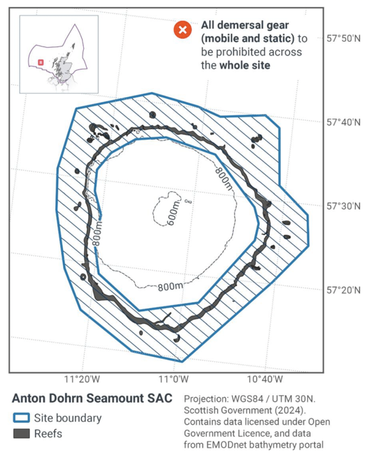
Anton Dohrn Seamount SAC
Protected feature: Stony, bedrock and biogenic reefs.
Feature condition: Unfavourable
Conservation objective: Recover to favourable condition.
Single proposed management option: Full site closure to demersal mobile gears and demersal static gears from the SAC.
Estimated Socio-economic impacts of proposed measures for Anton Dohrn Seamount SAC
Socio-economic impact |
Full site |
|---|---|
Average annual loss in value of landings (£000s, 2022 prices) |
0 – N.D* |
Direct + indirect reduction in GVA (PV) impact (£000s) 20 years |
0 – N.D* |
Average (mean) number of direct + indirect jobs (year on year, over 20 years), Full Time Equivalents |
0 – N.D* |
Overall ecosystem service benefits |
Low, for fish stock recovery and non-use cultural value |
Overall ecosystem service cost |
None |
*N.D = Value cannot be disclosed for confidentiality reasons, as it relates to the operations of fewer than five vessels.
Estimated Environmental impacts of proposed measures for Anton Dohrn Seamount SAC
Environmental impact |
Full site |
|---|---|
Benefits within site |
Negligible beneficial |
Spill over benefits |
Negligible beneficial |
Displacement effects |
Negligible adverse |
Effects from other gear types |
Negligible adverse |
Estimated overall environmental impact |
Negligible neutral |
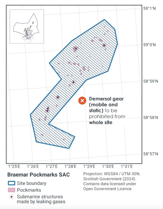
Braemar Pockmarks SAC
Protected feature: Submarine structures made by leaking gases.
Feature condition: Unfavourable – noting it is not considered feasible to restore some of the feature's attributes through management measures
Conservation objective: Restore to favourable condition.
Single proposed management option: Full site closure to demersal mobile gears and all demersal static gears from the SAC.
Estimated Socio-economic impacts of proposed measures for Braemar Pockmarks SAC
Socio-economic impact |
Full site |
|---|---|
Average annual loss in value of landings (£000s, 2022 prices) |
0 – 4.0 |
Direct + indirect reduction in GVA (PV) impact (£000s) 20 years |
0 – 34.2 |
Average (mean) number of direct + indirect jobs (year on year, over 20 years), Full Time Equivalents |
0 – 0.1 |
Overall ecosystem service benefits |
Low, for fish stock recovery and non-use cultural values |
Overall ecosystem service cost |
None |
Estimated Environmental impacts of proposed measures for Braemar Pockmarks SAC
Environmental impact |
Full site |
|---|---|
Benefits within site |
Minor beneficial |
Spill over benefits |
Negligible beneficial |
Displacement effects |
Negligible adverse |
Effects from other gear types |
Negligible adverse |
Estimated overall environmental impact |
Minor beneficial |
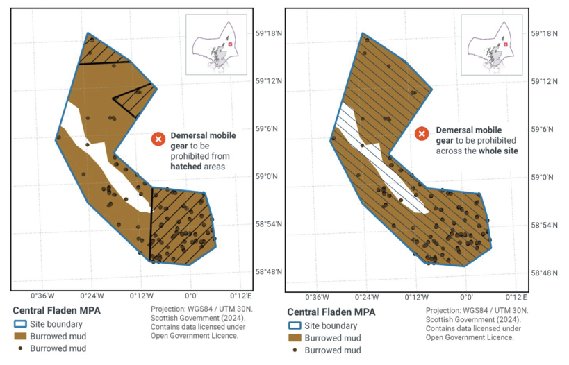
Central Fladen MPA
Protected feature: Burrowed mud.
Feature condition: Unfavourable
Conservation objective: Recover to favourable condition.
Proposed Management options:
Option 1: Zoned closure of demersal mobile gears. No demersal static gear measures applied.
Option 2: Full site closure to demersal mobile gears No demersal static gear measures applied.
Estimated socio-economic impacts of proposed measures for Central Fladen MPA
Socio-economic impact |
Zoned |
Full |
|---|---|---|
Average annual loss in value of landings (£000s, 2022 prices) |
104.0 – 493.0 |
2,620.0 |
Direct + indirect reduction in GVA (PV) impact (£000s) 20 years |
1007.8 – 4118.1 |
21,153.4 |
Average (mean) number of direct + indirect jobs (year on year, over 20 years), Full Time Equivalents |
1.4 – 6.2 |
33 |
Overall ecosystem service benefits |
Low – Moderate, for fish stock recovery, climate regulation and non-use cultural value. |
|
Overall ecosystem service cost |
Low, for impacts on fish stock recovery , climate regulation and non-use cultural value. |
Estimated Environmental impacts of proposed measures for Central Fladen MPA
Environmental impact |
Zoned |
Full |
|---|---|---|
Benefits within site |
Major beneficial |
Major beneficial |
Spill over benefits |
Minor beneficial |
Minor beneficial |
Displacement effects |
Moderate adverse |
Moderate adverse |
Effects from other gear types |
Negligible adverse |
Minor adverse |
Estimated overall environmental impact |
Moderate beneficial |
Minor beneficial |
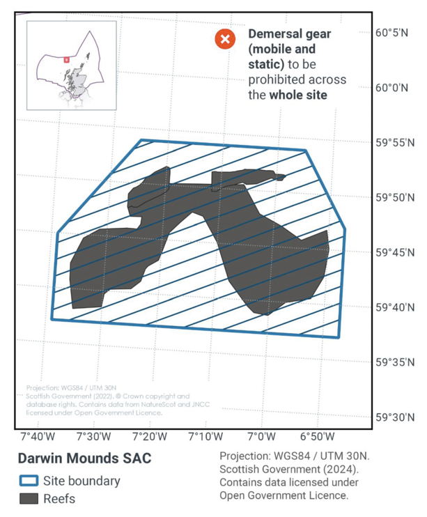
Darwin mounds SAC
Protected feature: Stony, bedrock and biogenic reefs.
Feature condition: Unfavourable
Conservation objective: Recover to favourable condition
Single proposed management option: Full site closure to demersal mobile gears and all demersal static gears from the SAC.
To note: equivalent measures are already in place prohibiting demersal mobile and demersal static gears through technical measures.
Estimated Socio-economic impacts of proposed measures for Darwin Mounds SAC
Socio-economic impact |
Zoned |
|---|---|
Average annual loss in value of landings (£000s, 2022 prices) |
0 |
Direct + indirect reduction in GVA (PV) impact (£000s) 20 years |
0 |
Average (mean) number of direct + indirect jobs (year on year, over 20 years), Full Time Equivalents |
0 |
Overall ecosystem service benefits |
0 |
Overall ecosystem service cost |
0 |
Estimated Environmental impacts of proposed measures for Darwin Mounds SAC
Environmental impact |
Zoned |
|---|---|
Benefits within site |
None |
Spill over benefits |
None |
Displacement effects |
None |
Effects from other gear types |
None |
Estimated overall environmental impact |
None |
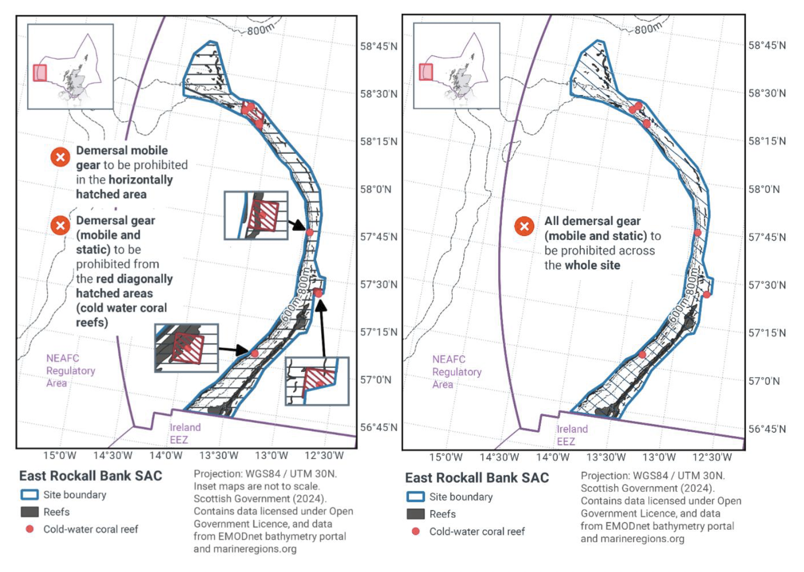
East Rockall Bank SAC
Protected features: Stony, bedrock and biogenic reef.
Feature condition: Unfavourable
Conservation objective: Restore to favourable condition.
Proposed management options:
Option 1: Zoned closure to demersal mobile gear and zoned closure to demersal static gear
Option 2: Full site closure to demersal mobile gear and demersal static gear
Estimated Socio-economic impacts of proposed measures for East Rockall Bank SAC
Socio-economic impact |
Zoned |
Full |
|---|---|---|
Average annual loss in value of landings (£000s, 2022 prices) |
0 - 49 |
209.0 – 372.0 |
Direct + indirect reduction in GVA (PV) impact (£000s) 20 years |
0 - 415 |
1943.4 – 3301.9 |
Average (mean) number of direct + indirect jobs (year on year, over 20 years), Full Time Equivalents |
0 – 0.6 |
2.6 – 4.7 |
Overall ecosystem service benefits |
Low – Moderate, for non-use cultural value |
|
Overall ecosystem service cost |
Minimal - Low, for impacts on fish stock recovery, climate regulation and Non-use cultural value |
Estimated Environmental impacts of proposed measures for East Rockall Bank SAC
Environmental impact |
Zoned |
Full |
|---|---|---|
Benefits within site |
Moderate beneficial |
Moderate beneficial |
Spill over benefits |
Minor beneficial |
Minor beneficial |
Displacement effects |
Minor adverse |
Moderate adverse |
Effects from other gear types |
None |
None |
Estimated overall environmental impact |
Moderate beneficial |
Minor beneficial |
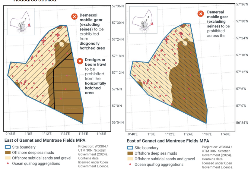
East of Gannet and Montrose Field MPA
Protected features: Offshore deep-sea muds and Ocean Quahog aggregations (including sands and gravels and their supporting habitat)
Feature condition: Unfavourable
Conservation objectives: Recover to favourable condition.
Proposed management options:
Option 1: Full site closure to mechanised dredge and beam trawling. Zoned closure to bottom trawling. No demersal static gear measures applied.
Option 2: Full site closure to demersal mobile gear. No demersal static gear measures applied.
Estimated Socio-economic impacts of proposed measures for East of Gannet and Montrose Field MPA
Socio-economic impact |
Zoned |
Full |
|---|---|---|
Average annual loss in value of landings (£000s, 2022 prices) |
0 – 11.0 |
0 – 308.0 |
Direct + indirect reduction in GVA (PV) impact (£000s) 20 years |
0 – 90.1 |
0 – 2460.4 |
Average (mean) number of direct + indirect jobs (year on year, over 20 years), Full Time Equivalents |
0 – 0.1 |
0 – 3.9 |
Overall ecosystem service benefits |
Low – Moderate for non-use cultural value |
|
Overall ecosystem service cost |
Minimal - Low for impacts on fish stock recovery, climate regulation and non-use cultural value |
Estimated Environmental impacts of proposed measures for East of Gannet and Montrose Field MPA
Environmental impact |
Zoned |
Full |
|---|---|---|
Benefits within site |
Moderate beneficial |
Major beneficial |
Spill over benefits |
Minor beneficial |
Moderate beneficial |
Displacement effects |
Minor adverse |
Minor adverse |
Effects from other gear types |
Minor adverse |
Minor adverse |
Estimated overall environmental impact |
Minor beneficial |
Major beneficial |
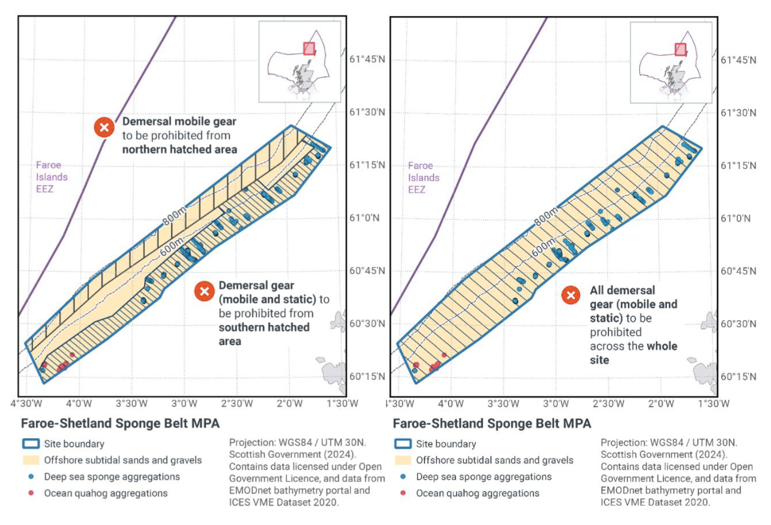
Faroe-Shetland Sponge Belt MPA
Protected features: Deep sea sponge aggregations, Offshore subtidal sands and gravels, Ocean Quahog aggregations.
Feature condition: Unfavourable
Conservation objectives: Recover to favourable condition.
Proposed management options:
Option 1: Zoned closure to demersal mobile gear and zoned closure to demersal static gear
Option 2: Full site closure to demersal mobile gear and demersal static gear
Estimated Socio-economic impacts of proposed measures for Faroe-Shetland Sponge Belt MPA
Socio-economic impact |
Zoned |
Full |
|---|---|---|
Average annual loss in value of landings (£000s, 2022 prices) |
0 - 120.0 |
0 – 566.0 |
Direct + indirect reduction in GVA (PV) impact (£000s) 20 years |
0 – 969.6 |
0 – 4536.9 |
Average (mean) number of direct + indirect jobs (year on year, over 20 years), Full Time Equivalents |
0 - 1.5 |
0 - 7.1 |
Overall ecosystem service benefits |
Low – Moderate, for fish stock recovery, research, and non-use cultural value. |
|
Overall ecosystem service cost |
Minimal - Low, for impacts on fish stock recovery, climate regulation and non-use cultural value. |
Estimated Environmental impacts of proposed measures for Faroe-Shetland Sponge Belt MPA
Environmental impact |
Zoned |
Full |
|---|---|---|
Benefits within site |
Moderate beneficial |
Moderate beneficial |
Spill over benefits |
Minor beneficial |
Minor beneficial |
Displacement effects |
Minor adverse |
Minor adverse |
Effects from other gear types |
Negligible adverse |
Negligible adverse |
Estimated overall environmental impact |
Moderate beneficial |
Moderate beneficial |
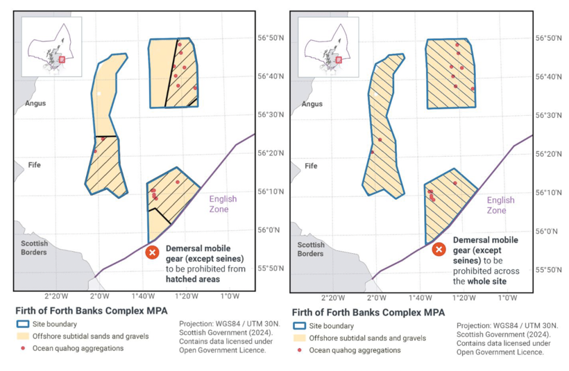
Firth of Forth Banks Complex MPA
Protected features: Ocean Quahog aggregations and Offshore subtidal sands and gravels.
Feature condition: Unfavourable
Conservation objectives: Recover to favourable condition.
Proposed management options:
Option 1: Zoned closure to demersal mobile gear (except seines). No demersal static gear measures applied
Option 2: Full site closure to demersal mobile gear (except seines). No demersal static gear measures applied
Estimated Socio-economic impacts of proposed measures for Firth of Forth Banks Complex MPA
Socio-economic impact |
Zoned |
Full |
|---|---|---|
Average annual loss in value of landings (£000s, 2022 prices) |
0 - 194.0 |
932.0 - 1,080.0 |
Direct + indirect reduction in GVA (PV) impact (£000s) 20 years |
0 – 1644.4 |
7902-9093.8 |
Average (mean) number of direct + indirect jobs (year on year, over 20 years), Full Time Equivalents |
0 - 2.4 |
11.7 – 13.6 |
Overall ecosystem service benefits |
Low – Moderate, for fish stock recovery, research and non-use cultural value. |
|
Overall ecosystem service cost |
Low, for impacts on fish stock recovery, climate regulation and non-use cultural value. |
Estimated Environmental impacts of proposed measures for Firth of Forth Banks Complex MPA
Environmental impact |
Zoned |
Full |
|---|---|---|
Benefits within site |
Major beneficial |
Major beneficial |
Spill over benefits |
Minor beneficial |
Moderate beneficial |
Displacement effects |
Minor adverse |
Moderate adverse |
Effects from other gear types |
Negligible adverse |
Minor adverse |
Estimated overall environmental impact |
Major beneficial |
Moderate beneficial |
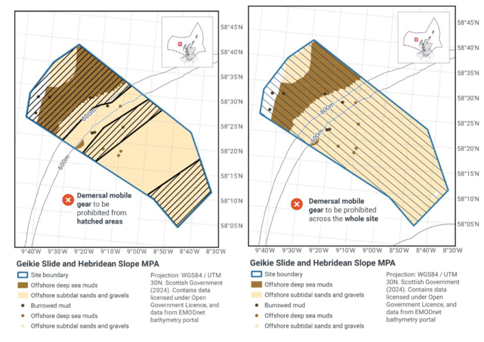
Geikie Slide and Hebridean Slope MPA
Protected features: Burrowed mud (seapens and burrowing megafauna), Offshore subtidal sands and gravels and Offshore deep-sea muds.
Feature Condition: Unfavourable
Conservation objectives: Recover to favourable condition.
Proposed management options:
Option 1: Zoned closure of demersal mobile gears. No demersal static gear measures applied.
Option 2: Full site closure to demersal mobile gears. No demersal static gear measures applied
Estimated Socio-economic impacts of proposed measures for Geikie Slide and Hebridean Slope MPA
Socio-economic impact |
Zoned |
Full |
|---|---|---|
Average annual loss in value of landings (£000s, 2022 prices) |
0 - 77 |
341 |
Direct + indirect reduction in GVA (PV) impact (£000s) 20 years |
0 – 640.5 |
2842.8 |
Average (mean) number of direct + indirect jobs (year on year, over 20 years), Full Time Equivalents |
0 – 1.0 |
4.3 |
Overall ecosystem service benefits |
Low for research and non-use cultural value. |
Low – Moderate, for research and non-use cultural value. |
Overall ecosystem service cost |
Minimal - Low, for impacts on fish stock recovery, climate regulation and non-use cultural value. |
Estimated Environmental impacts of proposed measures for Geikie Slide and Hebridean Slope MPA
Environmental impact |
Zoned |
Full |
|---|---|---|
Benefits within site |
Moderate beneficial |
Major beneficial |
Spill over benefits |
Minor beneficial |
Moderate beneficial |
Displacement effects |
Minor adverse |
Moderate adverse |
Effects from other gear types |
Minor adverse |
Moderate adverse |
Estimated overall environmental impact |
Minor beneficial |
Minor beneficial |
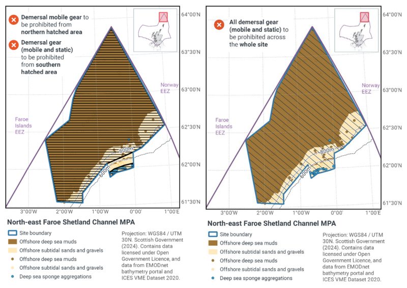
North-East Faroe-Shetland Channel MPA
Protected features: Deep sea sponge aggregations, Offshore sands and gravels and deep sea muds.
Feature condition: Deep sea sponge aggregations and Offshore sands and gravels favourable. Deep-sea muds unfavourable.
Conservation objectives: Recover Deep-sea muds to favourable condition. Conserve Deep sea sponge aggregations and Offshore sands and gravels in favourable condition.
Proposed management options:
Option 1: Zoned closure to demersal mobile gear and zoned closure to demersal static gear
Option 2: Full site closure to demersal mobile gear and demersal static gear
Estimated Socio-economic impacts of proposed measures for North-East Faroe-Shetland Channel MPA
Socio-economic impact |
Zoned |
Full |
|---|---|---|
Average annual loss in value of landings (£000s, 2022 prices) |
0 – 13.0 |
0 – 35.0 |
Direct + indirect reduction in GVA (PV) impact (£000s) 20 years |
0 – 104.9 |
0 – 282.1 |
Average (mean) number of direct + indirect jobs (year on year, over 20 years), Full Time Equivalents |
0 – 0.2 |
0 – 0.4 |
Overall ecosystem service benefits |
Low, for non-use cultural value. |
|
Overall ecosystem service cost |
None |
Estimated Socio-economic impacts of proposed measures for North-East Faroe-Shetland Channel MPA
Environmental impact |
Zoned |
Full |
|---|---|---|
Benefits within site |
Minor beneficial |
Minor beneficial |
Spill over benefits |
Negligible beneficial |
Negligible beneficial |
Displacement effects |
Negligible adverse |
Negligible adverse |
Effects from other gear types |
Negligible adverse |
Negligible adverse |
Estimated overall environmental impact |
Minor beneficial |
Minor beneficial |
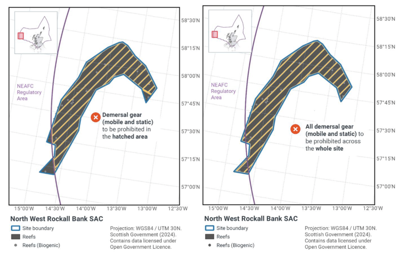
North West Rockall Bank SAC
Protected features: Stony and biogenic reef.
Feature condition: Unfavourable
Conservation objectives: Recover to favourable condition.
Proposed Management options:
Option 1: Zoned closure to demersal mobile gear and zoned closure to demersal static gear
Option 2: Full site closure to demersal mobile gear and demersal static gear
Estimated Socio-economic impacts of proposed measures for North West Rockall Bank SAC
Socio-economic impact |
Zoned |
Full |
|---|---|---|
Average annual loss in value of landings (£000s, 2022 prices) |
0 – 308.0 |
0 – 308.0 |
Direct + indirect reduction in GVA (PV) impact (£000s) 20 years |
0 – 2606 |
0 – 2606 |
Average (mean) number of direct + indirect jobs (year on year, over 20 years), Full Time Equivalents |
0 – 3.9 |
0 – 3.9 |
Overall ecosystem service benefits |
Low - moderate, for fish stock recovery and non-use cultural value |
|
Overall ecosystem service cost |
Low, for impacts on fish stock recovery, climate regulation and non-use cultural value |
Estimated Environmental impacts of proposed measures for North West Rockall Bank SAC
Environmental impact |
Zoned |
Full |
|---|---|---|
Benefits within site |
Moderate beneficial |
Moderate beneficial |
Spill over benefits |
Minor beneficial |
Minor beneficial |
Displacement effects |
Minor adverse |
Minor adverse |
Effects from other gear types |
None |
None |
Estimated overall environmental impact |
Moderate beneficial |
Moderate beneficial |
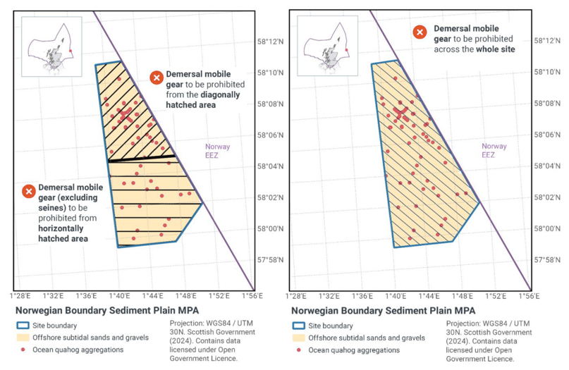
Norwegian Boundary Sediment Plain MPA
Protected features: Ocean Quahog aggregations (including sands and gravels as their supporting habitat).
Feature status: Unfavourable
Conservation objectives: Restore to favourable condition.
Proposed management options:
Option 1: Zoned closure of demersal seines. Full site closure to dredges, beam trawls, other demersal trawls, and pair seines. No demersal static gear measures applied
Option 2: Full site closure to demersal mobile gears. No demersal static gear measures applied
Estimated Socio-economic impacts of proposed measures for Norwegian Boundary Sediment Plain MPA
Socio-economic impact |
Zoned |
Full |
|---|---|---|
Average annual loss in value of landings (£000s, 2022 prices) |
0 – 38.0 |
0 – 46.0 |
Direct + indirect reduction in GVA (PV) impact (£000s) 20 years |
0 – 307.9 |
0 – 379.5 |
Average (mean) number of direct + indirect jobs (year on year, over 20 years), Full Time Equivalents |
0 – 0.5 |
0 – 0.6 |
Overall ecosystem service benefits |
Low, for non-use cultural value. |
|
Overall ecosystem service cost |
None |
Estimated Environmental impacts of proposed measures for Norwegian Boundary Sediment Plain MPA
Environmental impact |
Zoned |
Full |
|---|---|---|
Benefits within site |
Moderate beneficial |
Moderate beneficial |
Spill over benefits |
Negligible beneficial |
Negligible beneficial |
Displacement effects |
Minor adverse |
Minor adverse |
Effects from other gear types |
Negligible adverse |
Negligible adverse |
Estimated overall environmental impact |
Minor beneficial |
Minor beneficial |
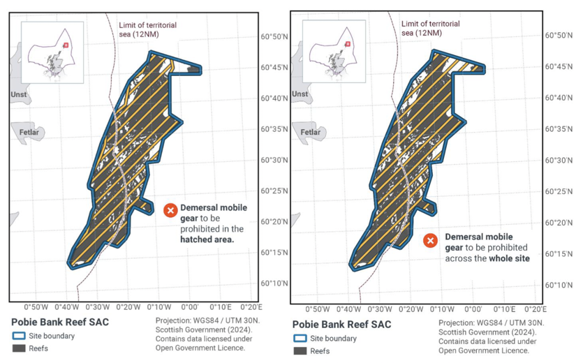
Pobie Bank SAC
Protected features: Bedrock and stony reef.
Feature status: Uncertain
Conservation objective: Conserve or restore in/to favourable condition.
Proposed Management options:
Option 1: Zoned closure of demersal mobile gears. No demersal static gear measures applied
Option 2: Full site closure to demersal mobile gears. No demersal static gear measures applied
Estimated Socio-economic impacts of proposed measures for Pobie Bank SAC
Socio-economic impact |
Zoned |
Full |
|---|---|---|
Average annual loss in value of landings (£000s, 2022 prices) |
0 - 426 |
0 – 606.0 |
Direct + indirect reduction in GVA (PV) impact (£000s) 20 years |
0 – 3441.7 |
0 – 4891.3 |
Average (mean) number of direct + indirect jobs (year on year, over 20 years), Full Time Equivalents |
0 – 5.4 |
0 – 7.6 |
Overall ecosystem service benefits |
Low - moderate, for fish stock recovery and non-use cultural value. |
|
Overall ecosystem service cost |
Low, for impacts on fish stock recovery, climate regulation and non-use cultural value. |
Estimated Environmental impacts of proposed measures for Pobie Bank SAC
Environmental impact |
Zoned |
Full |
|---|---|---|
Benefits within site |
Major beneficial |
Major beneficial |
Spill over benefits |
Minor beneficial |
Minor beneficial |
Displacement effects |
Minor adverse |
Minor adverse |
Effects from other gear types |
Minor adverse |
Minor adverse |
Estimated overall environmental impact |
Moderate beneficial |
Moderate beneficial |
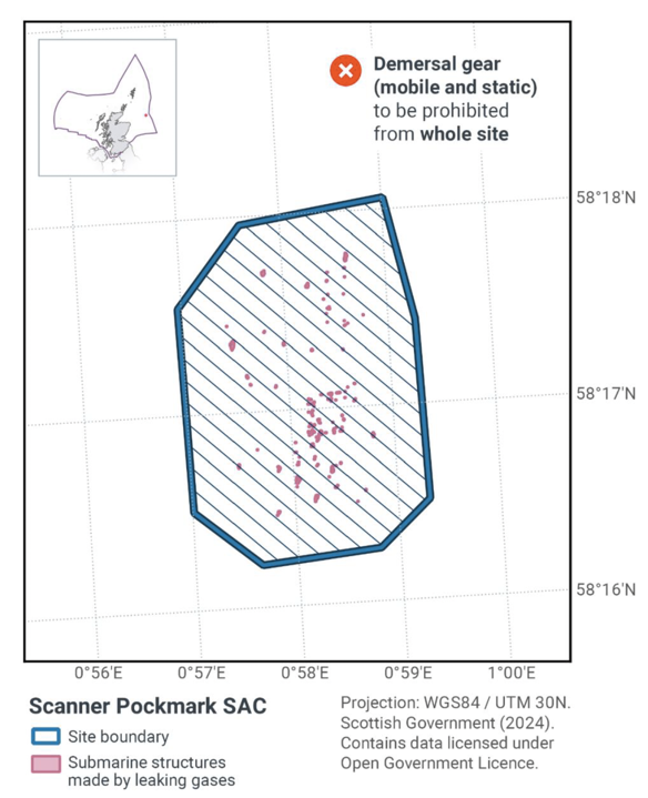
Scanner Pockmark SAC
Protected feature: Submarine structures made by leaking gases.
Feature status: Unfavourable – noting it is not considered feasible to restore some of the feature's attributes using management intervention
Conservation objective: Maintain or restore in/to favourable condition.
Single proposed management option: Full site closure to demersal mobile gears and demersal static gears from the SAC.
Estimated Socio-economic impacts of proposed measures for Scanner Pockmark SAC
Socio-economic impact |
Full |
|---|---|
Average annual loss in value of landings (£000s, 2022 prices) |
0 - 4.0 |
Direct + indirect reduction in GVA (PV) impact (£000s) 20 years |
0 – 31.7 |
Average (mean) number of direct + indirect jobs (year on year, over 20 years), Full Time Equivalents |
0 – 0 |
Overall ecosystem service benefits |
Low – moderate for non-use cultural value |
Overall ecosystem service cost |
None |
Estimated Environmental impacts of proposed measures for Scanner Pockmark SAC
Environmental impact |
Full |
|---|---|
Benefits within site |
Moderate beneficial |
Spill over benefits |
Negligible beneficial |
Displacement effects |
Minor adverse |
Effects from other gear types |
Negligible adverse |
Estimated overall environmental impact |
Minor beneficial |
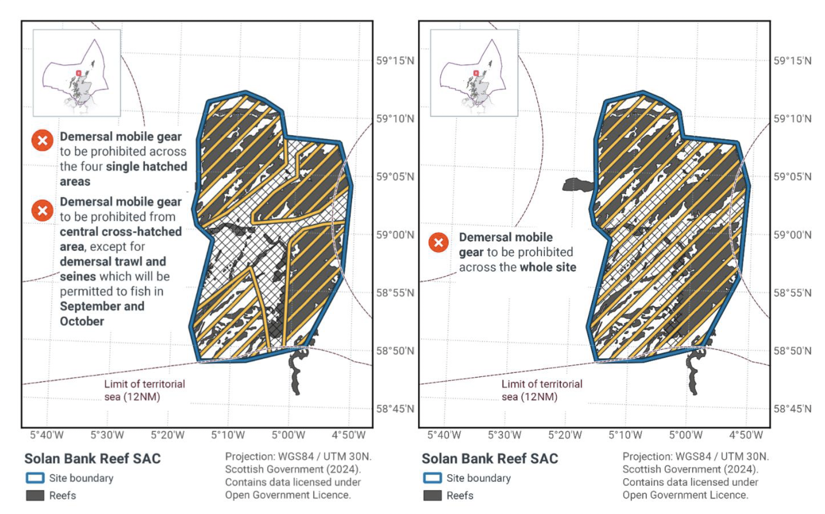
Solan Bank Reef SAC
Protected features: Bedrock and stony reef.
Feature status: Uncertain (lack of evidence)
Conservation Objective: Conserve or restore at/to favourable condition.
Proposed Management options:
Option 1: Zoned and temporal closure of demersal mobile gear. 10 months per year a full site closure to all demersal mobile gear, 2 months per year the centre of the site is open to demersal trawl and seine. No demersal static gear measures applied
Option 2: Full site closure to demersal mobile gears. No demersal static gear measures applied
Estimated Socio-economic impacts of proposed measures for Solan Bank Reef SAC
Socio-economic impact |
Zoned |
Full |
|---|---|---|
Average annual loss in value of landings (£000s, 2022 prices) |
555.0 – 577.0 |
639.0 – 660.0 |
Direct + indirect reduction in GVA (PV) impact (£000s) 20 years |
4636.7 – 4830.5 |
5331.1 – 5525.7 |
Average (mean) number of direct + indirect jobs (year on year, over 20 years), Full Time Equivalents |
7 – 7.3 |
8 – 8.3 |
Overall ecosystem service benefits |
Low - Moderate, for fish stock recovery and non-use cultural value. |
|
Overall ecosystem service cost |
Low, for impacts on fish stock recovery, climate regulation and non-use cultural value. |
Estimated Environmental impacts of proposed measures for Solan Bank Reef SAC
Environmental impact |
Zoned |
Full |
|---|---|---|
Benefits within site |
Major beneficial |
Major beneficial |
Spill over benefits |
Minor beneficial |
Minor beneficial |
Displacement effects |
Moderate adverse |
Moderate adverse |
Effects from other gear types |
Moderate adverse |
Negligible adverse |
Estimated overall environmental impact |
Negligible neutral |
Negligible neutral |
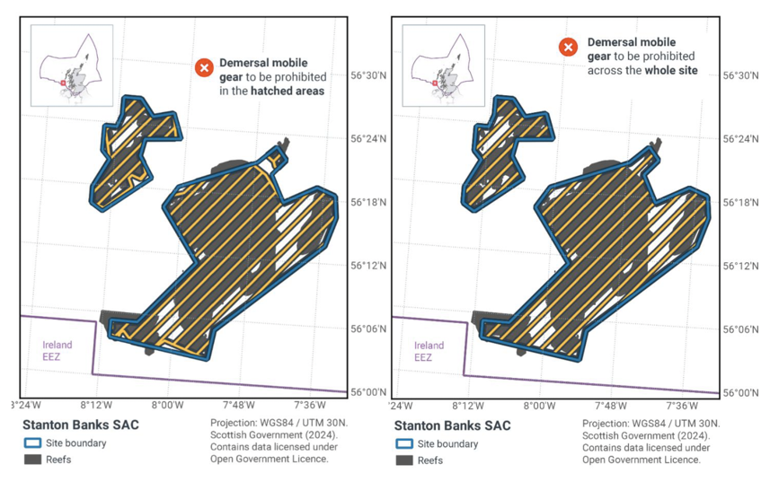
Stanton Banks SAC
Protected features: Bedrock and stony reef.
Feature status: Unfavourable
Conservation Objective: Recover to favourable condition.
Proposed Management options:
Option 1: Zoned closure of demersal mobile gears. No demersal static gear measures applied
Option 2: Full site closure to demersal mobile gears. No demersal static gear measures applied
Estimated Socio-economic impacts of proposed measures for Stanton Banks SAC
Socio-economic impact |
Zoned |
Full |
|---|---|---|
Average annual loss in value of landings (£000s, 2022 prices) |
0 – 1.0 |
0 – 5.0 |
Direct + indirect reduction in GVA (PV) impact (£000s) 20 years |
0 – 12.3 |
0 – 45.3 |
Average (mean) number of direct + indirect jobs (year on year, over 20 years), Full Time Equivalents |
0 - 0 |
0 – 0.1 |
Overall ecosystem service benefits |
Low, for fish stock recovery and non-use cultural values |
|
Overall ecosystem service cost |
None |
Estimated Environmental impacts of proposed measures for Stanton Banks SAC
Environmental impact |
Zoned |
Full |
|---|---|---|
Benefits within site |
Minor beneficial |
Minor beneficial |
Spill over benefits |
Negligible beneficial |
Negligible beneficial |
Displacement effects |
Negligible adverse |
Negligible adverse |
Effects from other gear types |
Negligible adverse |
Negligible adverse |
Estimated overall environmental impact |
Minor beneficial |
Minor beneficial |
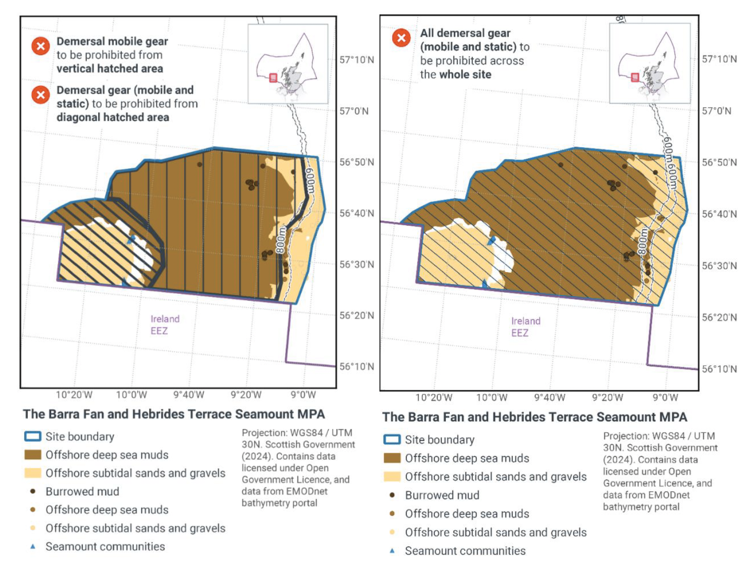
The Barra Fan and Hebrides Seamount MPA
Protected features: Burrowed Mud, Seamount communities, Offshore deep-sea muds and Offshore subtidal sands and gravels.
Feature status: Unfavourable
Conservation Objective: Restore to favourable condition.
Proposed management options:
Option 1: Zoned closure to demersal mobile gear and zoned closure to demersal static gear
Option 2: Full site closure to demersal mobile gear and demersal static gear
Estimated Socio-economic impacts of proposed measures for The Barra Fan and Hebrides Seamount MPA
Socio-economic impact |
Zoned |
Full |
|---|---|---|
Average annual loss in value of landings (£000s, 2022 prices) |
0 – 17.0 |
0 - 40.0 |
Direct + indirect reduction in GVA (PV) impact (£000s) 20 years |
0 – 143.0 |
0 – 330.4 |
Average (mean) number of direct + indirect jobs (year on year, over 20 years), Full Time Equivalents |
0 – 0.2 |
0 – 0.5 |
Overall ecosystem service benefits |
Low – Moderate, for fish stock recovery and non-use cultural value |
|
Overall ecosystem service cost |
Low, for impacts on fish stock recovery, climate regulation and non-use cultural value |
Estimated Environmental impacts of proposed measures for The Barra Fan and Hebrides Seamount MPA
Environmental impact |
Zoned |
Full |
|---|---|---|
Benefits within site |
Moderate beneficial |
Moderate beneficial |
Spill over benefits |
Minor beneficial |
Minor beneficial |
Displacement effects |
Negligible adverse |
Minor adverse |
Effects from other gear types |
Negligible adverse |
Minor adverse |
Estimated overall environmental impact |
Major beneficial |
Minor beneficial |
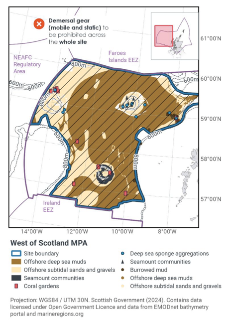
West of Scotland MPA
Protected features: Habitat features: Burrowed Mud (including sea pens), Coral gardens, Cold-water coral reefs, Deep-Sea Sponge aggregations, Offshore deep sea muds, Offshore subtidal sands and gravels, Seamount communities, Seamounts.
Mobile Species: Blue Ling, Leafscale gulper shark, Orange Roughy, Portuguese dogfish, Roundnose grenadier.
Feature status: Uncertain for habitat features due to lack of evidence, unfavourable for mobile, except Blue Ling at favourable.
Conservation Objective: All features recover to favourable condition. Except Blue Ling to conserve at favourable condition
Single proposed management option: Full site closure to demersal mobile gears and demersal static gears from the SAC.
Estimated Socio-economic impacts of proposed measures for West of Scotland MPA
Socio-economic impact |
Full |
|---|---|
Average annual loss in value of landings (£000s, 2022 prices) |
85.0 – 233.0 |
Direct + indirect reduction in GVA (PV) impact (£000s) 20 years |
789.3 – 2021.7 |
Average (mean) number of direct + indirect jobs (year on year, over 20 years), Full Time Equivalents |
1.1 – 2.9 |
Overall ecosystem service benefits |
Low – Moderate, for fish stock recovery, climate regulation and non-use cultural value. |
Overall ecosystem service cost |
Low, for impacts on fish stock recovery, climate regulation and non-use cultural value. |
Estimated Environmental impacts of proposed measures for West of Scotland MPA
Environmental impact |
Full |
|---|---|
Benefits within site |
Moderate beneficial |
Spill over benefits |
Minor beneficial |
Displacement effects |
Minor adverse |
Effects from other gear types |
Minor adverse |
Estimated overall environmental impact |
Minor beneficial |
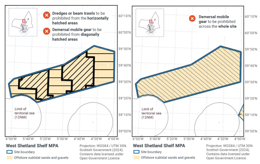
West Shetland Shelf MPA
Protected features: Offshore subtidal sands and gravels.
Feature status: Favourable
Conservation Objectives: Conserve in favourable condition
Proposed Management Options:
Option 1: Zoned closure of demersal mobile gears. No demersal static gear measures applied
Option 2: Full site closure to demersal mobile gears from the MPA. No demersal static gear measures applied
Estimated Socio-economic impacts of proposed measures for West Shetland Shelf MPA
Socio-economic impact |
Zoned |
Full |
|---|---|---|
Average annual loss in value of landings (£000s, 2022 prices) |
0 -121.0 |
0 -617.0 |
Direct + indirect reduction in GVA (PV) impact (£000s) 20 years |
0 – 1012.6 |
0 – 5155.5 |
Average (mean) number of direct + indirect jobs (year on year, over 20 years), Full Time Equivalents |
0 – 1.5 |
0 – 7.8 |
Overall ecosystem service benefits |
Low – Moderate, for fish stock recovery and non-use cultural value. |
|
Overall ecosystem service cost |
Low, for impacts on fish stock recovery, climate regulation and non-use cultural value. |
Estimated Environmental impacts of proposed measures for West Shetland Shelf MPA
Environmental impact |
Zoned |
Full |
|---|---|---|
Benefits within site |
Moderate beneficial |
Major beneficial |
Spill over benefits |
Minor beneficial |
Moderate beneficial |
Displacement effects |
Minor adverse |
Minor adverse |
Effects from other gear types |
Minor adverse |
Minor adverse |
Estimated overall environmental impact |
Minor beneficial |
Moderate beneficial |
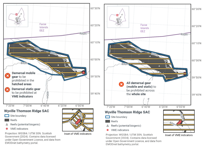
Wyville-Thompson Ridge SAC
Protected features: Stony and bedrock reef.
Feature Status: Unfavourable
Conservation Objectives: Restore to favourable condition
Proposed Management Options:
Option 1: Zoned closure to demersal mobile gear and zoned closure to demersal static gear
Option 2: Full site closure to demersal mobile gear and demersal static gear
Estimated Socio-economic impacts of proposed measures for Wyville-Thompson Ridge SAC
Socio-economic impact |
Zoned |
Full |
|---|---|---|
Average annual loss in value of landings (£000s, 2022 prices) |
0 – 3.0 |
0 – 178.0 |
Direct + indirect reduction in GVA (PV) impact (£000s) 20 years |
0 – 25.3 |
0 – 1278.0 |
Average (mean) number of direct + indirect jobs (year on year, over 20 years), Full Time Equivalents |
0 - 0 |
0 – 2.2 |
Overall ecosystem service benefits |
Low – Moderate, for fish stock recovery and non-use cultural value. |
|
Overall ecosystem service cost |
Minimal - Low, for impacts on fish stock recovery, climate regulation and non-use cultural value. |
Estimated Environmental impacts of proposed measures for Wyville-Thompson Ridge SAC
Environmental impact |
Zoned |
Full |
|---|---|---|
Benefits within site |
Moderate beneficial |
Moderate beneficial |
Spill over benefits |
Negligible beneficial |
Minor beneficial |
Displacement effects |
Minor adverse |
Minor adverse |
Effects from other gear types |
Negligible adverse |
Negligible adverse |
Estimated overall environmental impact |
Minor beneficial |
Moderate beneficial |
Contact
Email: marine_biodiversity@gov.scot
There is a problem
Thanks for your feedback