Partial Business and Regulatory Impact Assessment - Amendment of the West of Scotland Nature Conservation Marine Protected Area (NCMPA) site boundary
This assessment is undertaken to estimate the costs, benefits and risks of the proposed boundary amendment for the West of Scotland MPA that may impact the public, private or third sector.
Options
Option 1 - Do nothing
Option 1 is the ‘Do nothing’ option; this is the baseline scenario. Under this option, there is no change to the current designation of the West of Scotland MPA. The overlap of the UK Economic Exclusion Zone (EEZ) extending beyond the UK continental shelf limits and onto the Special Area and Faroese continental shelf remains. There are no changes to existing management remains unchanged such as the prohibition of deep-sea trawling (deeper than 800m) and use of set nets (deeper than 600m).
Option 2: Amendment to site boundary under the Marine and Coastal Access Act 2009
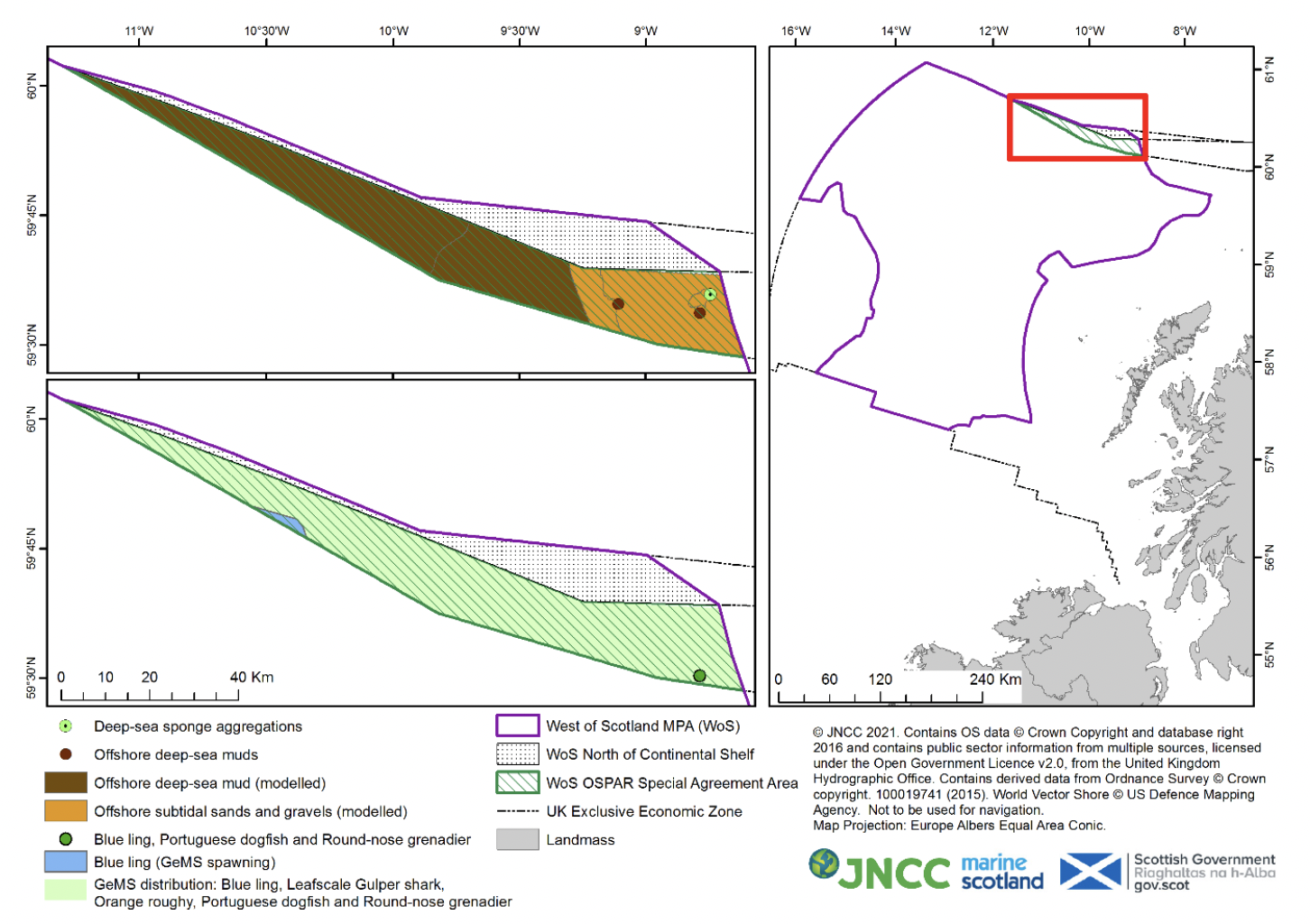
Option 2 involves amendment of the West of Scotland MPA site boundary which seeks to resolve an error in the original designation and remove the overlap of the UK Economic Exclusion Zone (EEZ) extending beyond the UK continental shelf limits and onto the Special Area and Faroese continental shelf is removed. This amendment seeks to remove the “Special Area” from the current MPA designation. This option would exclude this overlap and align the UK Continental Shelf limit, this would reduce the site size by a total of 2,307km2 (2.1% reduction), as known in Figure 1.
There would be no changes to the management measures already in place such as the prohibition of deep-sea trawling (deeper than 800m) and use of set nets (deeper than 600m).
JNCC has provided scientific advice of the biodiversity with the overlap of the Special Area, which shows that the area largely comprises of deep-sea sedimentary habitats, with sparse records present for two seabed features and three mobile species along with modelled distribution data for the seabed. These records are shown in Figure 2, with further information on the feature data available in Table 1. The Special Area that intersects with the site does not overlap with Key Geodiversity Areas but overlaps portions of the Geological/Geomorphological features of ‘Marine constructional deep-ocean’ and ‘Mass movement feature’.
Should Option 2 be selected and the West of Scotland site boundary be re-drawn to exclude the overlap with the Special Area, it is JNCC’s scientific opinion that this will not adversely affect the ecological integrity of the West of Scotland MPA, due primarily to the relatively small scale in site size reduction and the relative sparseness of feature records in the area.
| Feature | Modelled data | No. of records |
|---|---|---|
| Offshore deep-sea muds | UK SeaMap 2018 habitat map | 2 PSA records (GeMS) |
| Offshore subtidal sands & gravels | UK SeaMap 2018 habitat map | - |
| Deep-sea sponge aggregations | - | 1 bycatch record from MSS trawl survey |
| Blue Ling | GeMs distribution GeMS spawning | 1 bycatch record from MSS trawl survey |
| Round-nose grenadier | GeMs distribution | 1 bycatch record |
| Portuguese dogfish | GeMs distribution | 1 bycatch record |
| Orange roughy | GeMs distribution | - |
| Leaf-scale gulper shark | GeMs distribution | - |

Contact
Email: marine_biodiversity@gov.scot
There is a problem
Thanks for your feedback