Fisheries management measures within Scottish Offshore Marine Protected Areas (MPAs): consultation
Explains what the consultation aims to achieve, how it was developed, and what it will cover. It also outlines the consultation process and how to respond to it.
6. Part 2 Amendment of the West of Scotland MPA site boundary
We are seeking views and comments on the amendment of the site boundary for the West of Scotland NCMPA. This is proposed to resolve an issue with the existing site boundary.
The West of Scotland NCMPA was formally designated on the 25 September 2020 under the Marine and Coastal Access Act 2009. The site became the biggest MPA located in national waters in the North-East Atlantic.
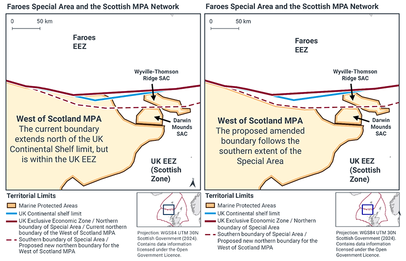
There is an area between Scotland and the Faroe Islands is sometimes referred to as the “Faroese Special Area” where the UK shares certain rights and jurisdiction with the Kingdom of Denmark and the Faroe Islands. Within this area the UK Economic Exclusion Zone (EEZ) extends beyond the UK continental shelf limits over the Faroese continental shelf.
The West of Scotland NCMPA is designated up to the UK EEZ boundary, so a small part of the site overlaps this Special Area, and also the Faroese continental shelf. As Scottish Ministers do not have jurisdiction in respect of the seabed and subsoil within the Faroese continental shelf an amendment to the existing NCMPA boundary is proposed to remove the area of the NCMPA which overlaps the Special Area, and the Faroese continental shelf.
Removing this area would mean Scottish Ministers would have full jurisdiction within the NCMPA. The removal of the Special Area from the site would reduce the NCMPA by 2,307km2, which is 2.14% of the full site, as shown in Figure 3.
The implementation of fisheries management measures proposed in Part 1 of this consultation (a full site restriction to demersal mobile and demersal static gear) are not dependent on this proposed amendment. Measures proposed would apply to the full site, defined by the site boundary in place.
6.1 Nature conservation
JNCC have advised that removing the Special Area from the NCMPA boundary would not adversely affect the ecological integrity of the site. This is due to the relatively small area of the site affected and the relative sparseness of feature records within the area. JNCC’s advice on the proposed boundary amendment is available online.
6.2 Amendments to legislation
The West of Scotland NCMPA was designated under the Marine and Coastal Access Act 2009. Under Section 122, the order may be amended by a further order. Section 119 requires the appropriate authority (in this case the Scottish Government) to consult any persons who they consider are likely to be interested in, or affected by, the making of the order.
The current Scottish Ministerial Order designating the site is available online and outlines the full site boundary coordinates. The Draft Order provided in this consultation provides the proposed new coordinates.
Contact
Email: marine_biodiversity@gov.scot
There is a problem
Thanks for your feedback